Track your progress, take practice exams, and study the flashcards in the app.
6.4 Chart Reading Final Drill
- Apply a repeatable six-step method to any sectional chart question
- Decode airspace class, floors and ceilings, airport data, obstructions, and coordinates from a sectional excerpt
- Recognize the three ways students most often misread a chart under time pressure
Roughly a third of the questions people miss on this exam come off a sectional chart. That is not because charts are hard. It is because chart reading is a skill, and skills need repetition rather than understanding. You already know what a magenta vignette means. What you need now is to decode one in ninety seconds while a timer runs.
This lesson is the method. The drill itself - twenty questions against the training sectional - follows in the quiz engine. Work the method here, then run the drill until you can do it without hesitating.
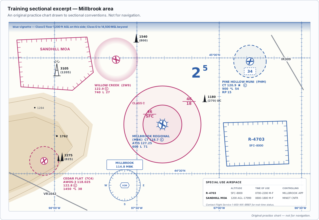
The six-step method
- Read the question first, and identify the single fact you need. A frequency. A floor. An airport name. A hazard. A distance. Say it to yourself before your eyes go anywhere near the chart.
- Find the figure, then find the numbered area box. These boxes are small and easy to lose. Put a finger on the box and leave it there for the whole question.
- Establish where you are. Before decoding anything, answer two questions: what airspace am I in, and what is the nearest airport? Almost every chart question resolves against one of those two anchors.
- Decode only the element the question asked about. A sectional excerpt contains hundreds of facts. You need exactly one, and reading the others costs you time and invites confusion.
- Match your reading to the options. If your answer is not among the three, you decoded the wrong element or the wrong area. Return to step 2. Do not force your reading into the nearest-looking option.
- Check the units and the reference. MSL or AGL. Statute or nautical miles. Feet or hundreds of feet. True or magnetic. Most wrong chart answers are the right number in the wrong unit.
Step 3 is the one people skip and it is the one that saves the most time. If you know you are inside a magenta dashed circle centerd on a non-towered airport, you already know the airspace is Class E to the surface, you already know you need ATC authorization, and half the plausible answers evaporate before you decode anything.
Working the four question types
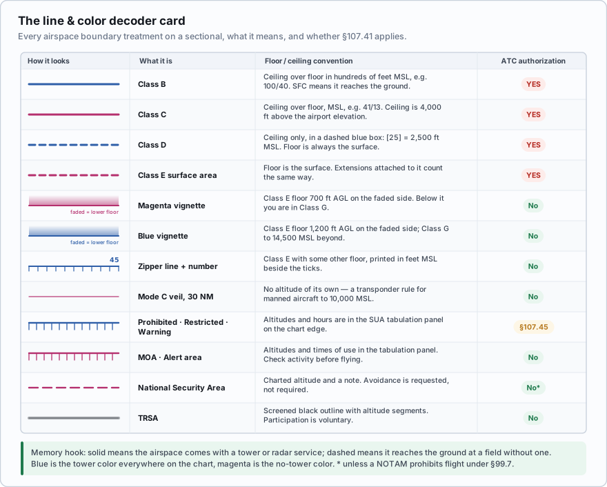
The method. Locate the area box. Work outward from it and identify every boundary you are inside. Step 1 - the solid blue rings. Solid blue means Class B. Segmented (dashed) blue means Class D. Step 2 - the solid magenta rings. Solid magenta means Class C. Dashed magenta means a Class E surface area. Step 3 - the vignettes. A soft, faded magenta band means Class E begins at 700 ft AGL on the side the fade points into. A soft blue band means Class E begins at 1,200 ft AGL. Neither of these requires authorization, because a drone at or below 400 ft AGL underneath them is in Class G. Step 4 - nothing at all. If your point is inside no boundary and under no vignette, it is Class G to 14,500 ft MSL, and no authorization is required. The decision. Authorization is required in Class B, C, D, and the surface area of Class E designated for an airport. Nowhere else. Then check the UAS Facility Map for the grid altitude at that location - remembering that the values come in 50-foot increments and that a 0-foot grid is not a prohibition, only the absence of automatic LAANC approval. The trap in this type. A magenta or blue vignette looks like an airspace boundary and is not one that concerns you. Learn to see the difference between a hard line and a soft fade at a glance.
Your operating site on the training sectional sits inside a soft magenta vignette band but inside no hard-edged circle. You plan to fly at 350 ft AGL. What authorization do you need?
- ATC authorization, because the magenta shading indicates Class E
- None, because at 350 ft AGL you are in Class G beneath a 700 ft Class E floor
- ATC authorization, because vignetted areas are Class C
Answer: B. A magenta vignette marks where Class E begins at 700 feet AGL. Below that floor the airspace is Class G, and Class G requires no authorization. Only Class B, C, D, and Class E surface areas - the dashed magenta circles - require prior ATC authorization under 107.41.
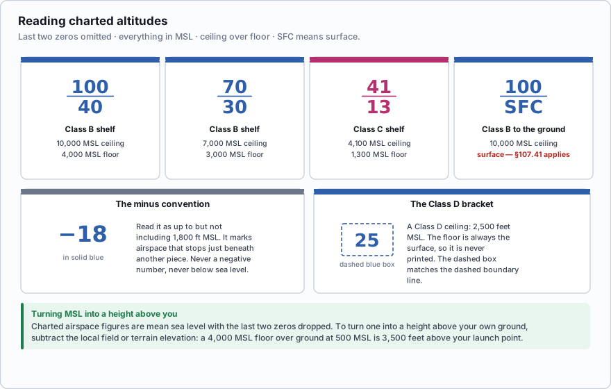
The method. Airspace altitudes are printed in boxes, as a pair of numbers separated by a horizontal line, in hundreds of feet MSL. Step 1 - read the box. The top number is the ceiling, the bottom is the floor. So 100 over 40 means a ceiling of 10,000 ft MSL and a floor of 4,000 ft MSL. Step 2 - handle the special cases. SFC as the bottom number means the airspace goes to the surface. A minus sign in front of a number means *up to but not including* that altitude - so minus 18 means up to but not including 1,800 ft MSL. A number inside a segmented bracket, like a boxed 25, is a Class D ceiling, also in hundreds of feet MSL. Step 3 - multiply by 100. This is the step people forget under pressure. 13 does not mean 13 feet. Step 4 - check MSL against AGL. Charted airspace altitudes are MSL. Your 400 ft limit is AGL. To compare them, add the ground elevation. If the field elevation is 1,200 ft and the Class C shelf floor is 1,700 ft MSL, that shelf floor is 500 ft above the ground - and your 400 ft AGL ceiling keeps you below it. The trap in this type. Answer options are routinely offered as the same number in AGL and in MSL. A shelf floor charted as 1,300 is 1,300 MSL, and an option reading 1,300 AGL is there to catch you.
The method. The block of small type beside an airport symbol packs sixteen elements into four lines. Learn the order and you can pull any one of them in seconds. Line 1 is the airport name, then the identifier in brackets, then whether the field is public or private. Line 2 is the communications line. CT followed by a frequency is the control tower. A star after the frequency means the tower is part time. The frequency immediately in front of an encircled C is the CTAF - the common traffic advisory frequency, which is the one you monitor. ATIS, AWOS and ASOS frequencies also appear here. Line 3 is field data: field elevation in feet MSL, then a bold L for lighting (a star before the L means lighting is pilot-controlled or operates part time), then the length of the longest runway in hundreds of feet, then U if UNICOM is available with its frequency. Line 4 carries remarks such as RP followed by a runway number, meaning right traffic is flown for that runway rather than the standard left. Worked reasoning. A question asks which frequency to use as CTAF at a given airport. Do not take the first frequency you see - the tower frequency and the CTAF may be different numbers, and at a part-time-tower field the CTAF is what applies when the tower is closed. Find the encircled C. The frequency immediately in front of it is the answer. The trap in this type. Runway length is in hundreds of feet. A runway shown as 51 is 5,100 feet long, not 51 feet and not 51 hundred meters.
Obstruction heights. An obstruction is annotated with two numbers: the upper is the height of the top above mean sea level, and the number below it, in brackets, is the height of the structure above the ground. So 2049 over (1149) is a structure whose top is 2,049 ft MSL, standing 1,149 ft tall, on ground that is therefore at 900 ft. Subtract to find the ground elevation. UC beside an obstruction means under construction - it may not yet be at its charted height, and it may not be lit. Latitude and longitude. Latitude lines run east-west and measure degrees north or south of the equator. Longitude lines run north-south and measure degrees east or west of the Prime Meridian. On a sectional the graticule is ticked in minutes, sixty to the degree. To find a feature at a given coordinate, find the degree lines first, then count minute ticks in from the correct side. In the contiguous United States, latitude runs roughly 25 to 49 degrees north and longitude roughly 67 to 125 degrees west, which lets you sanity-check that you are reading the right axis. Distances. Use the latitude scale, not a ruler: one minute of latitude equals one nautical mile. Count minute ticks up the side of the chart, and you have a distance scale that is always correct. The trap in this type. The bracketed obstruction number is height above ground, and the unbracketed one is MSL. Answer options offer both, plus the ground elevation you get by subtracting. Read which one the question asked for.
- Blue boundaries are Class B (solid) and Class D (dashed). Magenta boundaries are Class C (solid) and Class E surface areas (dashed)
- A magenta vignette means Class E starts at 700 ft AGL; a blue vignette means 1,200 ft AGL. Neither needs authorization
- Charted airspace altitudes are hundreds of feet MSL; your 400 ft limit is AGL
- The encircled C is the CTAF. Runway length is in hundreds of feet. RP means right traffic
- Obstruction: top number is MSL, bracketed number is AGL
- One minute of latitude equals one nautical mile - use the side of the chart as your scale
Three errors account for most missed chart questions. One: reading the wrong area box - the boxes are numbered and small, and reading area 2 when the question said area 3 produces a confidently wrong answer. Two: MSL and AGL confusion - the chart speaks MSL and the regulations speak AGL, and the distractor options always include both. Three: forgetting the multiplier - altitudes and runway lengths are in hundreds. Slow down for one extra second on each of these three and your chart score climbs.
An obstruction on the training sectional is annotated 2049 with (1149) beneath it. What is the elevation of the ground at its base?
- 1,149 feet MSL
- 900 feet MSL
- 2,049 feet MSL
Answer: B. The upper number is the top of the obstruction above mean sea level, and the bracketed number is the height of the structure above the ground. Subtract: 2,049 minus 1,149 equals 900 feet MSL at the base. Reading the bracketed figure as an elevation is the most common error on this question type.
Now run the drill. Twenty questions against the training sectional, untimed on your first pass so you can practice the method deliberately, then timed at ninety seconds a question. When you can hold ninety seconds with sixteen or more correct, chart questions have stopped being a risk on this exam.
Beyond the test: the skill you built here transfers directly to your working life. Before any job in unfamiliar territory you will look at the sectional, identify the airspace, check the UAS Facility Map grid, look for obstructions and wires, and confirm the field elevation so your AGL numbers mean something. Digital tools do most of this for you, and every one of them is occasionally wrong. Being able to read the chart yourself is what lets you notice.
- Use the six-step method: read the question first, find the numbered area, establish airspace and nearest airport, decode only what was asked, match to the options, and check units
- Blue is Class B and D, magenta is Class C and Class E surface areas; soft vignettes mark 700 ft and 1,200 ft Class E floors and need no authorization
- Charted altitudes are hundreds of feet MSL; the 400 ft limit is AGL - convert using the field or ground elevation
- In an airport data block, the encircled C is the CTAF, runway length is in hundreds of feet, and RP means right traffic
- Obstruction annotation: the top number is MSL and the bracketed number is height above ground
- One minute of latitude equals one nautical mile, so the side of the chart is a distance scale
- The three habitual errors are wrong area box, MSL versus AGL, and forgetting the hundreds multiplier