Track your progress, take practice exams, and study the flashcards in the app.
5.5 Airport Data Sources & Wildlife Hazards
- Choose the right source — sectional, Chart Supplement or NOTAM — for a given piece of airport information
- List what the Chart Supplement contains and state why it is the most comprehensive source
- Assess bird and wildlife hazards, respond to a raptor attack, and report a wildlife strike correctly
Airport information lives in three layers, and knowing which layer answers which question saves you time on the job and points on the test. The chart is the picture. The Chart Supplement is the book. NOTAMs are the news. One of them is the answer to a published FAA sample question you should expect to see.
Layer one: the sectional chart
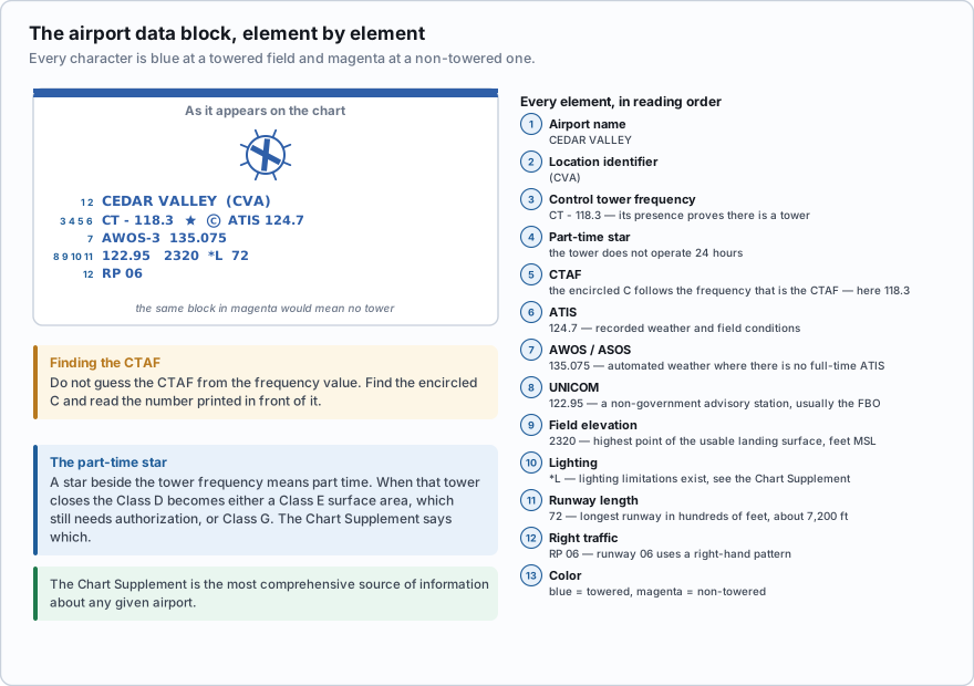
A sectional aeronautical chart is drawn at 1:500,000 and republished every 56 days. It shows the airport in relation to everything around it — airspace, terrain, obstructions, other fields — which is what you need when deciding whether a site is workable at all.
The data block compresses a dozen facts into a few lines: name and identifier, tower frequency with a star if part-time, ATIS or automated weather, the encircled C marking the CTAF, UNICOM, field elevation in feet MSL, a lighting code, the longest runway in hundreds of feet, and RP for right traffic. Blue means towered; magenta means not. Lesson 2.5 works through every element; the point here is what the block cannot tell you.
It cannot give you the tower's hours, the runway surface, whether the lights are pilot-controlled and on what frequency, the 90-foot line of trees on the approach end, or who to call. For that you need the book.
Layer two: the Chart Supplement U.S.
The Chart Supplement U.S. is a seven-volume series covering the conterminous United States, Puerto Rico and the Virgin Islands, published on the same 56-day cycle as the charts and free as a PDF from the FAA. Older pilots and older study guides still call it the Airport/Facility Directory — same book, renamed in 2016.
- Airport location, elevation, hours, and the airport manager's telephone number
- Runway dimensions, surface type and condition, weight bearing capacity, gradient and displaced threshold data
- Lighting codes, including how to activate pilot-controlled lighting and on which frequency
- Every communications frequency with the hours each is available — tower, ground, CTAF, UNICOM, ATIS, approach
- Navigation aids, instrument procedures, airspace notes, and weather sources with their telephone numbers
- Obstructions on the approach and departure paths, described individually
- Fuel, services and noise abatement procedures
- Free-text remarks — deer on the runway, glider operations, parachute jumping
- Airport sketches, plus special notices and Flight Service, ATC, FAA and NWS telephone numbers
That list is why the FAA asks the following question, and why it has exactly one right answer. The most comprehensive information on a given airport is provided by the Chart Supplement U.S. Not the sectional, not a terminal area chart, not NOTAMs. Learn the sentence in that shape, because the exam asks it in that shape.
Which source provides the most comprehensive information on a given airport?
- The Chart Supplement U.S.
- NOTAMs
- The VFR Terminal Area Chart
Answer: A. The Chart Supplement is the FAA's detailed textual directory of every public-use airport — runway data, all frequencies with their hours, lighting activation, obstructions, services, remarks and a sketch. Charts show location and relationships; NOTAMs show recent changes. Only the Chart Supplement is comprehensive.
Layer three: NOTAMs, the currency layer
Both the chart and the Chart Supplement run on a 56-day cycle, so either can be nearly two months old when you read it. A NOTAM — Notice to Air Missions — carries what has changed since: runway closed, beacon out, lighting unserviceable, a crane erected, GPS interference testing, a temporary flight restriction.
Get them from a briefing source such as 1800wxbrief.com, which is the answer the FAA gives to its own sample question on how a remote pilot should check NOTAMs. Lesson 2.9 covers the system in detail. What belongs here is the habit: the chart says what an airport normally is, the Chart Supplement says what it contains, the NOTAM says what is wrong with it today.
You are booked to photograph a grain terminal two miles from a small non-towered field, at 7:00 a.m., in November. The sectional shows the field magenta — no tower — Class G above your site to 700 ft, and a 380-foot tower a mile northeast. Authorization: none needed. The Chart Supplement gives you 3,400 ft of turf oriented 17/35, a CTAF of 122.9 that also keys the runway lights, the AWOS phone number, the manager's mobile, and a remark reading *deer and waterfowl on and in the vicinity of the airport*. The NOTAM says 17/35 is closed for resurfacing all month, so today's traffic is helicopters only — which means relaxing about the extended centerline and not relaxing at all about aircraft that arrive from any direction.
Birds and wildlife
A manned aircraft has a certificated windshield, redundant engines and a great deal of mass. Yours has thin plastic propellers, exposed motors, and weighs less than the average Canada goose. In a collision at 30 miles an hour, the drone loses. Wildlife is one of the more common ways to lose a small aircraft.
- Bird strike risk increases during migration: March through April, and August through November.
- Over 90 percent of reported bird strikes occur at or below 3,000 feet AGL — the band you share with the entire general aviation fleet. Strikes above that are common during migration.
- North America has four major flyways: Atlantic, Mississippi, Central and Pacific, plus many smaller crossing routes.
- The AIM's advice to a manned pilot meeting birds en route is to climb, because birds in a flock distribute themselves downward with the lead bird highest.
That last one needs a caveat. Climb is the manned-aircraft answer, and it is the answer to give on a question about avoiding a flock en route. In a small UAS you are capped at 400 ft AGL by §107.51, so climbing above them is often unavailable, and it burns battery and takes you further from your landing spot. A small multirotor's best escape is lateral and downward, then land.
Outside migration season, bird activity peaks around dawn and dusk — exactly when drone operators fly for the light — and concentrates near water, landfills, fields being worked, freshly mown grass, and airports.
Raptors
Hawks, falcons, eagles, ospreys, ravens and crows attack drones deliberately. To a red-tailed hawk a hovering quadcopter is an intruder inside a defended territory. Attacks cluster in nesting season, near ridgelines and cliffs where raptors ride lift, and over open farmland and water. The warning comes before the strike: a bird circling and gaining height above you, reappearing, tucking its wings.
- Descend immediately and land. Raptors attack from above and will almost never follow an aircraft down to the ground or to a person.
- Do not climb, which takes you toward the bird's preferred attack position.
- Do not try to outrun it. A peregrine dives faster than anything you can buy, and a chase makes the drone look like fleeing prey.
- Stop hovering. A stationary aircraft is an easy target and reads as a challenge.
- Move the operation. A nesting pair will keep coming back.
- Give a visual observer the specific job of watching for birds over open country, water or a ridge.
The reflex answer to a bird encounter is "climb above them," and for a manned aircraft meeting a flock en route that is correct and testable. For your aircraft it is usually wrong: you have a 400-foot ceiling and a raptor owns the altitude above you. Read the question — manned flight and flocks, climb; your small UAS and an attacking raptor, get down and land.
Reporting a wildlife strike
The FAA maintains a National Wildlife Strike Database, and the procedure for feeding it is AC 150/5200-32, *Reporting Wildlife Aircraft Strikes* — currently revision C, dated 31 July 2024. Reporting is voluntary but strongly encouraged, from anyone with knowledge of a strike: pilots, airport staff, maintenance personnel, controllers.
- Report when you witnessed the strike, when there is damage or evidence on the aircraft, when remains are found within 250 feet of a runway centerline or 1,000 feet of a runway end, or when wildlife had a significant effect on the operation — an aborted takeoff, an emergency stop.
- Which species: all birds and bats, terrestrial mammals of one pound or more, reptiles meeting the size criteria, and any federally or state-listed species.
- How: electronic submission is preferred, at faa.gov/go/wildlife; the paper FAA Form 5200-7, Bird/Other Wildlife Strike Report, is the backup.
- Remains can go with the form to the Smithsonian Feather Identification Lab for free species identification. Do not send remains to the FAA.
Keep one distinction clean. The wildlife strike report is voluntary and feeds the wildlife database. If the same event caused a serious injury, any loss of consciousness, or more than $500 of damage to property other than your aircraft, then §107.9 applies and a report to the FAA is mandatory within 10 calendar days. Two reports, two systems, two obligations.
Your aircraft is struck by a hawk during a survey flight. The drone is destroyed on impact with the ground; nothing else is damaged and nobody is hurt. What reporting is required?
- A mandatory report to the FAA within 10 calendar days under §107.9
- No mandatory report; a voluntary wildlife strike report to the FAA wildlife database is encouraged
- An immediate report to the NTSB
Answer: B. Section 107.9 counts damage to property other than the small unmanned aircraft. Your own destroyed aircraft does not trigger it, however expensive, and nobody was injured, so no §107.9 report is required. The wildlife strike report under AC 150/5200-32 is voluntary but encouraged, and is submitted at faa.gov/go/wildlife or on FAA Form 5200-7.
- The Chart Supplement U.S. is the most comprehensive source of information on a given airport. Published every 56 days; formerly the Airport/Facility Directory.
- Sectional for location and airspace, Chart Supplement for depth, NOTAMs for currency.
- Bird strike risk peaks March-April and August-November; over 90 percent of strikes occur at or below 3,000 ft AGL.
- Manned guidance for a flock en route is to climb, because birds distribute downward with the leader highest.
- For a small UAS under raptor attack, the answer is the opposite: descend and land.
- Wildlife strike reporting is voluntary, under AC 150/5200-32, via faa.gov/go/wildlife or FAA Form 5200-7.
- §107.9 is separate and mandatory — 10 calendar days for serious injury, loss of consciousness, or over $500 damage to other property.
The Chart Supplement's remarks section is the most underused page in aviation. It is free text written by people who know the field, and it will tell you that the grass strip floods, that a glider club operates on weekends, that there is an unlighted 60-foot silo on short final. Before any job within a couple of miles of an airport, read the remarks.
- Airport information comes in three layers: the sectional for the picture, the Chart Supplement for the detail, and NOTAMs for what has changed since
- The Chart Supplement U.S. is published every 56 days, was formerly the Airport/Facility Directory, and is the most comprehensive source of information on a given airport
- It carries runway and surface data, all frequencies with their hours, lighting activation, obstructions, services, the airport manager's phone number and free-text remarks
- Bird strike risk peaks March through April and August through November, and over 90 percent of reported strikes occur at or below 3,000 ft AGL
- Manned pilots are told to climb to avoid a flock because birds distribute downward; a small UAS under raptor attack should descend and land instead
- Wildlife strike reporting under AC 150/5200-32 is voluntary and is submitted at faa.gov/go/wildlife or on FAA Form 5200-7, with remains going to the Smithsonian
- A wildlife strike that causes serious injury or more than $500 of damage to other property still requires a mandatory §107.9 report within 10 calendar days