Track your progress, take practice exams, and study the flashcards in the app.
5.4 Runway Markings, Signs & Airport Lighting
- Identify runway and taxiway markings, including displaced thresholds, chevrons and closed-surface markings
- Read any airport sign from its color scheme alone
- Interpret beacon colors, runway edge lighting, VASI and PAPI indications, and the segmented circle
You will probably never taxi an aircraft, so treat this lesson as reading a language rather than learning a procedure. Markings, signs and lights are how an airfield tells everyone what it is doing. A remote pilot who can read them knows from the fence line which runway is active and whether the field is legally IFR. All of it is testable, and most of it comes down to color.
The color rule that sorts half the questions
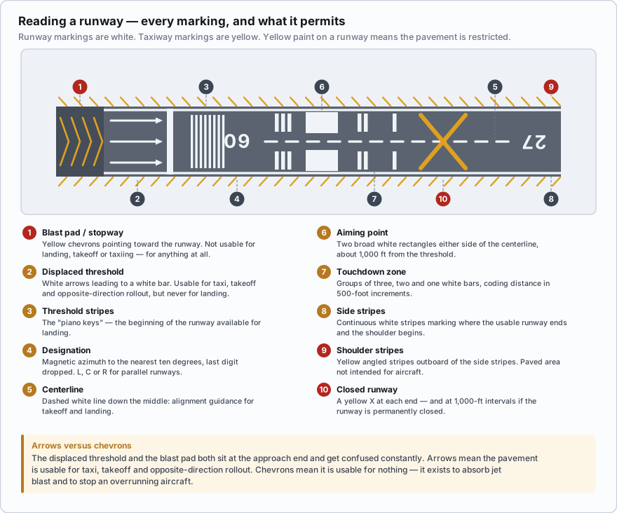
Runway markings are white. Taxiway markings are yellow. Anything painted yellow on a runway is a warning that the pavement is not for normal use — chevrons, shoulder stripes, closed-runway crosses. Hold that rule and a surprising number of questions answer themselves.
| Marking | Looks like | Means |
|---|---|---|
| Designator | Large white number, sometimes with L, C or R | The runway's magnetic azimuth to the nearest ten degrees, last digit dropped |
| Centerline | Dashed white line down the middle | Alignment guidance for takeoff and landing |
| Threshold | Eight or more long white stripes, the "piano keys" | The beginning of the runway available for landing |
| Aiming point | Two broad white rectangles either side of the centerline | The visual aiming point, about 1,000 ft from the threshold |
| Touchdown zone | Groups of one, two and three white bars | Distance coding in 500-foot increments from the threshold |
| Side stripes | Continuous white stripes along both edges | Where the usable runway ends and the shoulder begins |
| Shoulder stripes | Yellow angled stripes outboard of the side stripes | Paved area not intended for aircraft |
| Displaced threshold | White bar across the runway, white arrows leading up to it, arrowheads just before it | Landing threshold moved down the runway; the pavement before it is usable for taxi, takeoff, and rollout from the opposite direction — but not for landing on |
| Blast pad / stopway | Yellow chevrons pointing toward the runway | Pavement not usable for landing, takeoff or taxiing at all |
| Closed runway | Yellow X at each end, and at 1,000-ft intervals if permanently closed | The runway is closed |
The displaced threshold and the blast pad get confused, and the difference matters. Both sit at the approach end. Arrows mean the pavement is usable for taxi, takeoff, and rollout after landing in the other direction. Chevrons mean it is usable for nothing; it exists to absorb jet blast and to stop an overrunning aircraft.
You are surveying a small airfield and see yellow chevrons painted at the approach end of the runway, pointing toward it. What do they mean?
- The threshold has been displaced and the pavement may still be used for takeoff
- The pavement is a blast pad or stopway and is not usable for landing, takeoff or taxiing
- The runway is temporarily closed
Answer: B. Yellow chevrons mark a blast pad or stopway — pavement aligned with the runway that is unusable for any aircraft operation. A displaced threshold is marked with white arrows and a white threshold bar, and that pavement can be used for taxi, takeoff and opposite-direction rollout. A closed runway is marked with a yellow X.
Taxiways and hold lines
- Taxiway centerline — a single continuous yellow line.
- Continuous double yellow edge lines — the pavement beyond is not for aircraft. Do not cross. Dashed double yellow means the adjoining pavement, such as an apron, is usable.
- Runway holding position marking — four yellow lines, two solid and two dashed. The solid lines are always on the side where the aircraft must hold. Crossing without a clearance is a runway incursion, one of the most serious errors in aviation.
- ILS critical area holding position marking — two solid yellow lines joined by rungs, so it looks like a ladder. It keeps a metal aircraft out of the instrument landing system's beam.
- Surface painted holding position sign — a red rectangle with a white inscription painted on the pavement, used where a sign alone is easy to miss.
Signs, by color
| Sign type | Colors | Means |
|---|---|---|
| Mandatory instruction | Red background, white inscription | An entrance to a runway or critical area, or an area you may not enter. Runway holding position signs and No Entry signs. Stop. |
| Location | Black background, yellow inscription, yellow border | Identifies the taxiway or runway you are on now |
| Direction | Yellow background, black inscription, with arrows | The intersecting taxiways leading out of this intersection and which way to turn |
| Destination | Yellow background, black inscription | The taxi route to a place on the airport — a ramp, a terminal, a runway |
| Information | Yellow background, black inscription | Frequencies, noise abatement notes, areas not visible from the tower |
| Runway distance remaining | Black background, white numeral | Thousands of feet of landing runway remaining |
A compact way to hold it: red means stop, black tells you where you are, yellow tells you where you can go. A runway holding position sign reads "15-33", and the numbers are arranged to match reality — runway 15's threshold is to the left, runway 33's to the right.
Airport beacons
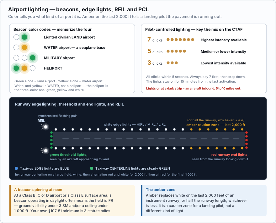
A rotating beacon on a tower or a hangar roof announces the airport at night and in poor weather. The color combination tells you what kind of airport it is, and this is a favorite exam item.
| Flashes | Airport type |
|---|---|
| White and green | Lighted civilian land airport |
| White and yellow | Water airport — a seaplane base |
| White, white and green (green with two quick white flashes) | Military airport |
| Green, yellow and white | Heliport |
| Green alone | Land airport |
| Yellow alone | Water airport |
Then there is the rule that turns the beacon into a weather instrument. At an airport in Class B, C or D airspace or a Class E surface area, operation of the beacon during daylight hours often means the ground visibility is less than 3 statute miles and/or the ceiling is less than 1,000 feet — the field is IFR. The AIM warns against relying on it alone, but a beacon spinning at noon puts your own §107.51 minimum of 3 statute miles visibility in genuine doubt.
Driving past an airport at 2:00 p.m. you notice the rotating beacon is operating. The airport lies within Class D airspace. What does this most likely indicate?
- The tower is closed and the airspace has reverted to Class G
- Ground visibility is less than 3 statute miles and/or the ceiling is less than 1,000 feet
- A military aircraft is expected
Answer: B. At a Class B, C, D or Class E surface area airport, a beacon operating during daylight hours often indicates the field is IFR — visibility below 3 SM and/or a ceiling below 1,000 ft. It is an indication rather than a guarantee, and the AIM warns against relying on it alone, but it is a useful signal that your own 3 SM visibility minimum may not be met.
Runway and taxiway lighting
- Runway edge lights are white, in three intensities: HIRL, MIRL and LIRL.
- On instrument runways, amber replaces white on the last 2,000 feet, or half the runway length, whichever is less — a caution zone telling a landing pilot the pavement is running out.
- Threshold lights show green to an aircraft approaching to land; the runway end lights show red to an aircraft on the runway looking down it. Same fixtures, different sides.
- REIL — Runway End Identifier Lights — are a pair of synchronised flashing lights either side of the threshold, to make a runway stand out against city lights or featureless terrain.
- Taxiway edge lights are blue; taxiway centerline lights are steady green.
- In-runway centerline lights on large fields run white until the last 3,000 ft, alternating red and white for 2,000 ft, then all red for the final 1,000 ft.
Pilot-controlled lighting is the one to memorize cold. At an unattended field, the lighting is switched on by the arriving pilot keying the microphone on the CTAF.
- 7 clicks within 5 seconds — highest intensity available.
- 5 clicks within 5 seconds — medium or lower intensity.
- 3 clicks within 5 seconds — lowest intensity available.
- Always key 7 first, to make sure everything comes on, then step down if it is too bright.
- The lights stay on for 15 minutes from the last activation.
That has a direct operational consequence. If you are working near a dark rural strip at dusk and the runway lights suddenly come on, an aircraft is inbound and within radio range — five to ten miles out. Nothing requires an announcement for the lights themselves. It is a free warning; take it.
VASI and PAPI
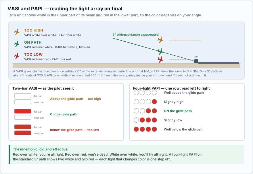
These are light arrays beside the runway that tell an approaching pilot whether they are on the correct descent path, usually 3 degrees. Each unit projects white in the upper part of its beam and red in the lower part, so the color you see depends on your angle.
| What the pilot sees | Position |
|---|---|
| Red over red | Below the glide path — too low |
| Red over white | On the glide path |
| White over white | Above the glide path — too high |
The rhyme is old, crude, and effective: red over white, you're all right; red over red, you're dead; white over white, you'll fly all night.
| Lights | Position |
|---|---|
| Four white | Well above the glide path |
| Three white, one red | Slightly high |
| Two white, two red | On the glide path |
| One white, three red | Slightly low |
| Four red | Well below the glide path |
A VASI gives safe obstruction clearance within plus or minus 10 degrees of the extended runway centerline out to 4 NM from the threshold; a PAPI does the same to 3.4 NM. That defines the funnel where landing aircraft will be. On a 3-degree path an aircraft is roughly 320 ft AGL at 1 NM and 640 ft at 2 NM. Do not put a drone in it.
An aircraft on final reports a single row of four lights beside the runway showing two white and two red. Where is it relative to the glide path?
- Above the glide path
- On the glide path
- Below the glide path
Answer: B. A four-light PAPI shows two white and two red on the standard 3-degree glide path. Four white is well high, four red is well low, and each single light that changes color is one step off. On that 3-degree path the aircraft is about 320 ft AGL a nautical mile out — inside your altitude band.
The segmented circle and its wind indicators
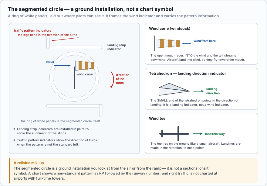
The segmented circle is a ground installation, not a chart symbol — a ring of white panels laid out where pilots can see it from the air and from the ramp. It centers and frames the wind indicator and carries the pattern information.
- Wind direction indicator — a wind cone (windsock), wind tee or tetrahedron near the operational runway. The open mouth of a windsock faces into the wind and the tail streams downwind. Aircraft land into the wind, so they fly toward the mouth.
- Landing direction indicator — a tetrahedron, whose small end points in the direction of landing.
- Landing strip indicators — installed in pairs to show the alignment of the landing strips.
- Traffic pattern indicators — paired with the landing strip indicators, they show the direction of turns when the pattern is not the standard left.
Three reliable mix-ups. White and yellow is a water airport, not a heliport — the heliport is the three-color one, green, yellow and white. Taxiway edge lights are blue, not green — green is the taxiway centerline. And the segmented circle is a ground installation you look at from the air or the ramp; it is not a sectional chart symbol. A chart shows a non-standard pattern as RP followed by the runway number.
SIDA — the fence line you do not cross
A Security Identification Display Area is a limited-access part of an airport where everyone must display a badge issued under 49 CFR Part 1542. SIDAs can take in the air operations area and the secured areas where passengers board. Boundaries are posted with warning signs.
The AIM is blunt about the consequences: anyone observed entering a SIDA without proper identification may be reported to the TSA or to airport security and may be subject to civil and criminal fines and prosecution. Separately, 49 CFR Part 1540 requires an airman certificate holder to present the certificate for inspection on request from TSA — so carry it, as §107.7 already requires.
For drone work that is specific and practical. Airports hire operators for pavement surveys, perimeter inspections, obstruction photography and marketing footage, and any of those may put you inside a SIDA. Your remote pilot certificate is not access credentials. You need the airport authority's permission, almost always an escort, frequently a badge and a background check, and a separate conversation about airspace authorization. Start weeks ahead, not on the morning of the shoot.
- Runway markings are white; taxiway markings are yellow. Yellow on a runway means restricted pavement.
- Displaced threshold = white arrows and a white bar, usable for taxi, takeoff and opposite-direction rollout. Chevrons = yellow, usable for nothing. Closed = yellow X.
- Holding position marking is four yellow lines, two solid two dashed; hold on the solid side. The ILS critical area marking looks like a ladder.
- Signs: red = mandatory, black = location, yellow = direction, destination or information; black with white numerals = runway distance remaining.
- Beacons: white-green civil land, white-yellow water, white-white-green military, green-yellow-white heliport. A beacon in daylight at a controlled field means IFR.
- Edge lights white, amber caution zone on the last 2,000 ft of an instrument runway; green threshold, red runway end; blue taxiway edge, green taxiway centerline.
- Pilot-controlled lighting: 7 clicks high, 5 medium, 3 low, within 5 seconds; lights stay on 15 minutes.
- Red over white, you're all right. Red over red, you're dead. White over white, you'll fly all night. PAPI on path is two white, two red.
- Tetrahedron small end points in the landing direction; the windsock's mouth faces into the wind.
A standard FAA wind cone stands fully extended at about 15 knots and aligns itself in as little as 3, so it doubles as an anemometer you can read from a quarter mile away. Half-drooped is roughly 7 or 8 knots — a useful sanity check against the wind figure in your app, which is usually a forecast rather than a measurement.
- Runway markings are white and taxiway markings are yellow; yellow paint on a runway marks pavement that is restricted or unusable
- White arrows and a bar mark a displaced threshold, which is usable for taxi, takeoff and opposite-direction rollout; yellow chevrons mark a blast pad usable for nothing; a yellow X marks a closed runway
- Hold short markings are four yellow lines, two solid and two dashed, and the aircraft holds on the solid side
- Signs are read by color: red is mandatory, black is location, yellow is direction, destination or information
- Beacons: white-green civil land, white-yellow water, white-white-green military, green-yellow-white heliport; a beacon running in daylight at a controlled field means the field is IFR
- Pilot-controlled lighting responds to 7, 5 or 3 microphone clicks within 5 seconds for high, medium and low intensity, and stays on for 15 minutes
- VASI on path is red over white; PAPI on path is two white and two red; a SIDA needs a Part 1542 badge that your remote pilot certificate does not provide