Track your progress, take practice exams, and study the flashcards in the app.
5.3 Airport Operations & Traffic Patterns
- Name the five legs of a standard traffic pattern and state the standard pattern altitudes
- Convert a runway number to a magnetic heading and explain why every runway has two numbers
- Place an aircraft on the airport diagram from a spoken position report, and from a tower transmission
Manned aircraft near an airport are the most predictable aircraft in the sky, and that is deliberate. The traffic pattern is a standardized rectangle flown at a standardized height in a standardized direction so that pilots who have never met can share a runway safely. For you that predictability is a gift: knowing the pattern and the runway in use tells you where the airplanes are without seeing them.
The kinds of airport you will meet
- Towered. A control tower sequences the traffic. Charted in blue, usually inside Class B, C or D — though a tower needs weather reporting to support surface-based controlled airspace, and a few lack it.
- Non-towered. No controller; pilots self-announce and fly the standard pattern. Charted in magenta. The great majority of US airports.
- Heliport. A circled H. Helicopters are not bound to the fixed-wing rectangle — the AIM allows about 500 ft AGL and closer in — and they arrive from any direction at any hour.
- Seaplane base. An anchor. Traffic operates over the water and approaches low across the shoreline, often with no charted pattern.
- Military. Blue, with the service name. Fast, often low, frequently arriving via an overhead break rather than a civil pattern.
- Private use, marked (Pvt), and closed, marked with an X — neither means quiet airspace. The traffic and the airspace are real.
The five legs
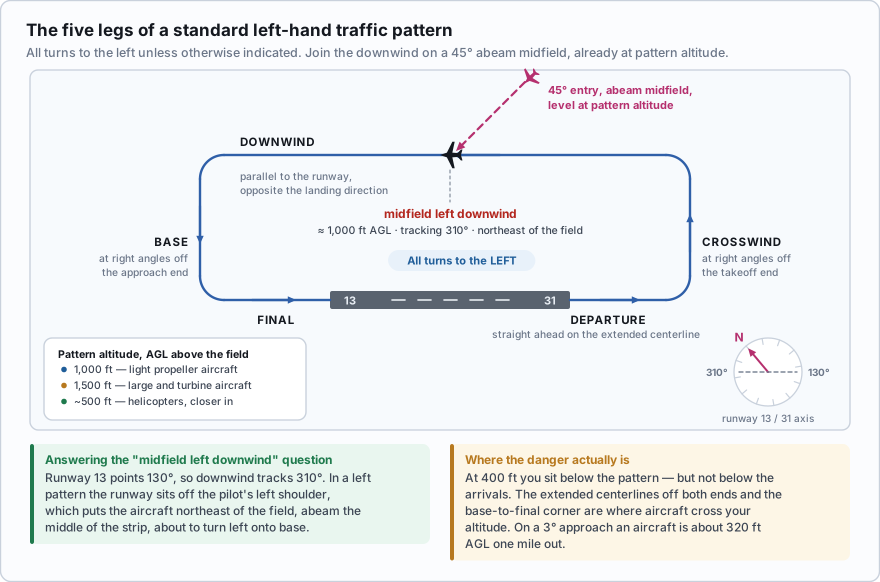
| Leg | What it is | Where the aircraft is |
|---|---|---|
| Departure | Begins after takeoff and continues straight ahead along the extended runway centerline | Off the departure end, climbing, directly in line with the runway |
| Crosswind | At right angles to the landing runway off its takeoff end | Beyond the far end, turning across |
| Downwind | Parallel to the landing runway, in the opposite direction of landing | Alongside the runway, roughly half a mile to a mile out, at pattern altitude |
| Base | At right angles to the landing runway off its approach end, from downwind to the extended centerline | Off the approach end, descending, turning toward the runway |
| Final | Aligned with the runway from base to touchdown | On the extended centerline, descending, low |
| Upwind | Parallel to the runway in the direction of landing — an extension of departure used for spacing | Alongside or beyond the runway, climbing or level |
Two rules govern the whole thing. All turns in the traffic pattern are made to the left unless otherwise indicated, and aircraft enter the downwind at a 45-degree angle abeam the midpoint of the runway, already at pattern altitude. Entering while descending is specifically discouraged, because a descending aircraft cannot see what is beneath it.
- 1,000 ft AGL — the standard pattern altitude for propeller-driven light aircraft.
- 1,500 ft AGL — large and turbine-powered aircraft, or 500 ft above the established pattern altitude, whichever is higher.
- About 500 ft AGL — helicopters, which also fly a tighter pattern closer to the runway.
- Pattern altitudes are AGL above the airport elevation, not MSL. Add the field elevation to convert.
Now put your own operation into that picture. At 400 ft AGL you sit below the pattern almost everywhere — but the pattern is not the dangerous part. The danger is where aircraft climb and descend through your altitude: the extended runway centerlines off both ends, out three or four miles, and the base-to-final corner. An aircraft on a 3-degree approach is about 320 ft AGL one nautical mile out. That is your airspace.
What is the recommended traffic pattern altitude for a large or turbine-powered airplane at a non-towered airport?
- 1,000 ft AGL, the same as light aircraft
- Not less than 1,500 ft AGL, or 500 ft above the established pattern altitude
- 2,000 ft AGL
Answer: B. Light propeller aircraft use 1,000 ft AGL. Large and turbine-powered aircraft fly higher — not less than 1,500 ft AGL, or 500 ft above the established pattern altitude — so that the two groups are vertically separated in the pattern.
Right traffic
Some runways use right-hand turns instead, usually because of terrain, noise-sensitive neighborhoods or a parallel runway. The sectional then prints RP and the runway number in the data block: RP 06 means runway 06 uses a right-hand pattern. Right traffic is not charted at airports with full-time towers, because there the controller assigns the pattern.
On the ground the same information appears in the traffic pattern indicators of a segmented circle, covered in the next lesson. Both answer one question: which side of the runway will the airplanes be on? That is the side to stay away from.
Runway numbers are compass headings
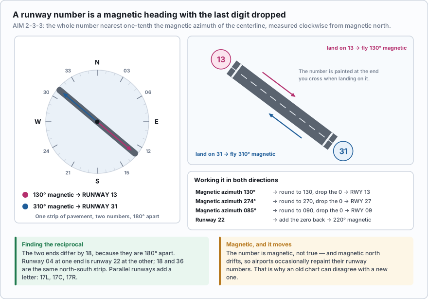
The runway number is the whole number nearest one-tenth the magnetic azimuth of the centerline of the runway, measured clockwise from magnetic north.
Translated: take the runway's magnetic heading, round it to the nearest ten degrees, and drop the last digit. A runway aligned 130° magnetic is runway 13. A runway aligned 274° is runway 27. A runway aligned 085° is runway 09. To go the other way, add a zero: runway 22 points 220° magnetic.
Every runway has two numbers, 180 degrees apart, because you can land from either end and pilots land into the wind when they can. The number at the end you are looking at is the heading you fly taking off from it. Runway 13 at one end is 31 at the other; 18 and 36 are the same north-south strip. The two ends always differ by 18 — add 18 if the number is 18 or less, subtract 18 if it is more. Parallel runways add a letter: 17L and 17R, or 17L, 17C, 17R.
The number is magnetic, not true, and magnetic north drifts, so airports occasionally repaint their runway numbers. That is why an old chart can disagree with a new one.
An airport has a single runway, and one end is marked 04. What is the number at the other end, and what magnetic heading does it face?
- Runway 40, facing 400 degrees
- Runway 22, facing 220 degrees
- Runway 14, facing 140 degrees
Answer: B. The two ends are 180 degrees apart, which is 18 on a runway number. Runway 04 faces 040 degrees magnetic; 4 plus 18 is 22, so the other end is runway 22, facing 220 degrees magnetic.
Working the FAA's own question, step by step
One of the FAA's published sample questions gives you a transmission and asks where the aircraft is. It looks harder than it is, and it becomes easy once you do it on paper a couple of times. Here it is.
Step 1. Turn the runway number into a heading. Runway 13 points 130° magnetic — southeast. An airplane landing on it is flying southeast. Step 2. Downwind is the reciprocal. The downwind leg is parallel to the runway but flown opposite the landing direction. 130 + 180 = 310°. The aircraft is tracking northwest. Step 3. "Left" tells you which side. In a left pattern every turn is to the left, so the runway sits off the pilot's left shoulder on downwind. Ninety degrees left of 310° is 220° — from the aircraft, the runway lies southwest. Step 4. Flip it. If the runway is southwest of the aircraft, the aircraft is northeast of the runway: 220 − 180 = 040°. Step 5. "Midfield" puts it abeam the middle of the strip, not off either end — roughly half a mile to a mile out, at about 1,000 ft AGL. Answer: northeast of the field, alongside the middle of the runway, at pattern altitude, about to turn left onto base. The FAA's three choices for this item are East, South and West; northeast is not offered, so East is the correct selection. Do not let a missing compass point talk you out of the geometry. The shortcut: stand on the runway facing the landing direction. For left traffic the pattern is off your left. Facing 130°, your left hand points to 040° — northeast. Same answer in one step.
Draw it. Genuinely — a line at 130/310, an arrow pointing southeast for the landing direction, then the rectangle offset to the northeast. Ten seconds with a pencil beats a minute of arguing with yourself, and you will be handed scratch paper at the testing center.
Two reliable wrong turns. First, people answer with the direction the runway points — runway 13 points southeast, so "southeast" feels right, but the question asked where the *aircraft* is, and it is on the downwind, which is the reciprocal and offset to one side. Second, left and right in a pattern are always from the pilot's point of view flying the landing direction, never from a map reader's.
Listening to a tower
At a towered field the pilots are not self-announcing, so the position reports come from the controller instead. The same geometry applies, and controller phraseology is even more standardized. A few examples, translated.
- "Skyhawk three four whiskey, cleared for takeoff runway two seven, left turn approved." — a light single rolling westbound and turning left, which from a westbound heading means south.
- "Baron five one bravo, enter left base runway one eight, report two miles." — a twin joining short of the pattern on the east side, descending on the extended centerline south of the field.
- "Cessna two romeo, extend downwind, I'll call your base." — held out beyond its normal turning point, so it will be further from the field than a standard pattern.
- "Helicopter niner eight lima, remain at or below five hundred." — transiting the surface area at 500 ft AGL or less, not on the runway at all, and it can be anywhere over the field.
You are listening for three things and nothing else: what type, where, and which way next. That is enough to keep a drone out of the way, and it is available to anyone with a receiver and this lesson.
One last point on why this matters when you are nowhere near an airport. Aircraft do not teleport into the pattern: arrivals descend from cruise several miles out, and departures climb through your altitude band for the first mile or two. A job site four miles off the end of a runway sits directly under the arrival stream even though the airport is a speck on the horizon.
- The five legs in order: departure, crosswind, downwind, base, final. Upwind is the sixth term — parallel to the runway in the landing direction.
- All pattern turns are to the left unless otherwise indicated. Entry is a 45-degree join to the downwind abeam midfield, at pattern altitude.
- 1,000 ft AGL light propeller aircraft; 1,500 ft AGL large and turbine; about 500 ft AGL helicopters.
- Right traffic is charted as RP plus the runway number, and shown on the ground by the segmented circle's traffic pattern indicators. Not charted at full-time towered fields.
- A runway number is its magnetic azimuth rounded to the nearest ten degrees with the last digit dropped; the two ends differ by 18 — add 18 if the number is 18 or less, subtract 18 if it is more.
- Left downwind for runway 13 puts the aircraft northeast of the field, tracking 310 degrees, at about 1,000 ft AGL.
An ADS-B receiver — the box that picks up the position broadcasts most manned aircraft now transmit — will draw nearby traffic on a tablet, and it is excellent. Treat it as a supplement. Not every aircraft transmits, low-altitude coverage is uneven, and it tells you nothing about the one that called ten miles out a moment ago. Pattern knowledge works with a dead battery.
- Airports come as towered, non-towered, heliport, seaplane base, military and private; each generates a different traffic profile
- The standard pattern has five legs — departure, crosswind, downwind, base and final — flown with left turns unless charted otherwise, entered at 45 degrees abeam midfield at pattern altitude
- Pattern altitude is 1,000 ft AGL for light propeller aircraft and 1,500 ft AGL for large and turbine aircraft; helicopters operate around 500 ft AGL
- Right traffic is charted as RP plus the runway number and is not shown at full-time towered fields
- A runway number is its magnetic azimuth rounded to the nearest ten degrees with the last digit dropped; the two ends are 180 degrees apart and differ by 18
- Midfield left downwind for runway 13 puts an aircraft northeast of the field, tracking 310 degrees, at pattern altitude
- The real conflict zones for a drone are the extended runway centerlines and the base-to-final corner, where aircraft climb and descend through 400 ft