Track your progress, take practice exams, and study the flashcards in the app.
3.9 Reading a TAF, Winds Aloft, AIRMETs, SIGMETs and PIREPs
- Decode a TAF including FM, BECMG, TEMPO and PROB change groups
- Decode a winds and temperatures aloft forecast, including the coded high-speed groups
- Match each in-flight advisory to the hazard it covers and the period it is valid for
- Identify the current graphical weather products and the legacy products they replaced
A METAR tells you what is happening. Everything in this lesson tells you what is going to happen, which is what drives a decision about a job three hours from now. The FAA testing supplement still prints several of these products in their legacy text format, so you will learn both the current form and the old one.
The Terminal Aerodrome Forecast
A TAF is a forecast for the area within about 5 statute miles of an airport reference point. Roughly 700 US airports get one. It reads like a METAR because most of the code is shared, but the differences matter.
- Issued four times a day, at approximately 0000Z, 0600Z, 1200Z and 1800Z.
- Valid for 24 hours; 30 hours at selected major airports.
- A TAF contains no altimeter setting, no temperature, no remarks section, and no RVR. If you need any of those, you need a METAR.
- P6SM means visibility greater than 6 statute miles. Anything 6 SM or less is stated as a number.
- The valid period is written DDHH/DDHH — 1218/1318 means from the 12th at 1800Z to the 13th at 1800Z.
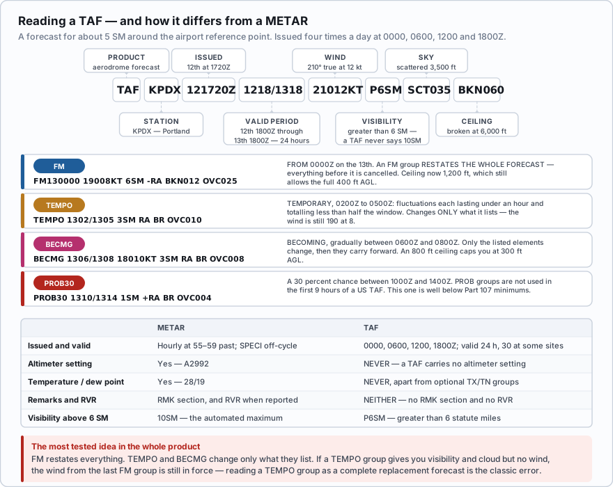
| Group | Meaning | What it changes |
|---|---|---|
| FMddhhmm | From — a rapid, significant change occurring within about an hour | Everything. An FM group restates the complete forecast; all previous conditions are cancelled |
| BECMG ddhh/ddhh | Becoming — a gradual change over the stated window | Only the elements listed. Everything not mentioned carries forward unchanged |
| TEMPO ddhh/ddhh | Temporary — fluctuations each lasting under an hour and totalling less than half the window | Only the elements listed. The underlying forecast still applies between fluctuations |
| PROB30 / PROB40 | A 30 or 40 percent probability of the stated conditions | Only the elements listed. Not used in the first 9 hours of a US TAF |
FM restates everything. TEMPO and BECMG change only what they list. If a TEMPO group gives you visibility and cloud but no wind, the wind from the last FM group is still in force. Students routinely read a TEMPO group as a complete replacement forecast and get the wind wrong.
TAF KOKC 051130Z 0512/0618 14008KT 5SM BR BKN030 FM051600 16010KT P6SM SKC FM052300 20013G20KT 4SM SHRA OVC020 TEMPO 0600/0604 2SM TSRA OVC008CB FM060600 21015KT P6SM SCT040 Header: Oklahoma City, issued the 5th at 1130Z, valid from the 5th at 1200Z to the 6th at 1800Z. That is 30 hours, so this is one of the selected long-period sites. Initial period: wind 140 at 8 kt, visibility 5 SM in mist, broken 3,000 — a 3,000 ft ceiling. FM051600: from 1600Z, wind 160 at 10, visibility greater than 6 SM, sky clear. A complete restatement. FM052300: from 2300Z, wind 200 at 13 gusting 20, 4 SM in rain showers, overcast 2,000. TEMPO 0600/0604: between 0000Z and 0400Z on the 6th, brief periods of 2 SM in a thunderstorm with rain and an 800 ft overcast containing cumulonimbus. Only visibility, weather and cloud are listed — the wind is still 200 at 13 gusting 20 from the FM group above. FM060600: from 0600Z on the 6th, wind 210 at 15, greater than 6 SM, scattered 4,000. Drone read: a good window from 1600Z to 2300Z on the 5th. After that the ceiling drops to 2,000 with gusts, and the overnight TEMPO puts thunderstorms over the field. If your job is on the 6th, aim for after 0600Z.
TAF KPDX 121720Z 1218/1318 21012KT P6SM SCT035 BKN060 FM130000 19008KT 6SM -RA BKN012 OVC025 BECMG 1304/1306 18010KT 3SM RA BR OVC008 PROB30 1308/1312 1SM +RA BR OVC004 Header: Portland, issued the 12th at 1720Z, valid the 12th at 1800Z through the 13th at 1800Z — a standard 24-hour TAF. Initial period: 210 at 12, greater than 6 SM, scattered 3,500 and broken 6,000. Ceiling 6,000 ft. Comfortable. FM130000: from midnight Zulu, 190 at 8, 6 SM in light rain, broken 1,200, overcast 2,500. Ceiling is now 1,200 ft — still enough for 400 ft AGL, since you need 900. BECMG 1304/1306: gradually between 0400Z and 0600Z, wind 180 at 10, 3 SM in rain and mist, overcast 800. All four elements are listed, so all four change and then carry forward. A 800 ft ceiling caps you at 300 ft AGL, and 3 SM is exactly the legal minimum with zero margin. PROB30 1308/1312: a 30 percent chance between 0800Z and 1200Z of 1 SM in heavy rain and mist with a 400 ft overcast. That is well below Part 107 minimums. Drone read: fly it before 0400Z or reschedule.
A TAF reads FM141800 24015G25KT P6SM SCT050, followed by TEMPO 1420/1423 3SM TSRA BKN015CB. During the TEMPO period, what wind should you plan for?
- Calm, because the TEMPO group does not mention wind
- 240 at 15 gusting 25, carried forward from the FM group
- Unknown — the TEMPO group cancels the previous forecast
Answer: B. A TEMPO group changes only the elements it lists. It listed visibility, weather, and cloud, so the wind from the preceding FM group still applies. Only an FM group restates the entire forecast.
Winds and temperatures aloft (FB)
The winds and temperatures aloft forecast — coded FB, and still widely called FD — gives forecast wind and temperature at fixed altitudes above mean sea level for hundreds of locations. For a drone pilot the 3,000-foot line is the useful one: it is the closest published forecast to the air immediately above your operating band, and it tells you the direction the surface wind will trend toward as the day mixes.
- Levels: 3,000, 6,000, 9,000, 12,000, 18,000, 24,000, 30,000, 34,000 and 39,000 ft MSL.
- Format ddffTT — first two digits are direction in tens of degrees true, next two are speed in knots, last two are temperature in °C.
- No winds are forecast for a level within 1,500 ft of the station elevation.
- No temperature is forecast for the 3,000 ft level, or for any level within 2,500 ft of the station elevation.
- 9900 means light and variable — forecast speed less than 5 knots.
- If the direction code is 51 through 86, subtract 50 from the direction and add 100 to the speed. 731960 is 230 degrees at 119 knots, minus 60 °C.
- Above 24,000 ft all temperatures are negative and the minus sign is omitted. 259040 at 30,000 ft is 250 degrees at 90 knots, minus 40 °C.
FT 3000 6000 9000 12000 18000 24000 30000 STL 2016 2124+05 2235-01 2348-06 2461-17 2578-27 259040 3,000 ft: 200 degrees true at 16 knots. No temperature — the 3,000 ft level never carries one. 6,000 ft: 210 at 24 knots, plus 5 °C. 9,000 ft: 220 at 35 knots, minus 1 °C. 12,000 ft: 230 at 48 knots, minus 6 °C. 18,000 ft: 240 at 61 knots, minus 17 °C. 24,000 ft: 250 at 78 knots, minus 27 °C. 30,000 ft: 250 at 90 knots, minus 40 °C — above 24,000 the sign is dropped. If that same line had read 9900 at 3,000 ft, the forecast would be light and variable, under 5 knots. And a group of 731960 would decode as 73 − 50 = 230 degrees, 19 + 100 = 119 knots, minus 60 °C.
An FB forecast shows 7420-08 for a station at the 12,000 ft level. What is the wind?
- 740 degrees at 20 knots
- 240 degrees at 120 knots
- 740 degrees at 120 knots
Answer: B. A direction code between 51 and 86 signals a coded high-speed group. Subtract 50 from the direction (74 − 50 = 24, so 240 degrees) and add 100 to the speed (20 + 100 = 120 knots). The temperature is minus 8 °C.
In-flight advisories
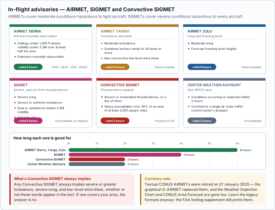
| Product | Covers | Issued | Valid |
|---|---|---|---|
| AIRMET Sierra | IFR conditions — ceilings under 1,000 ft and/or visibility under 3 SM over at least half the area — and extensive mountain obscuration | Every 6 hours (0245, 0845, 1445, 2045Z) plus amendments | 6 hours |
| AIRMET Tango | Moderate turbulence, sustained surface winds of 30 knots or more, and non-convective low-level wind shear | Same schedule | 6 hours |
| AIRMET Zulu | Moderate icing, and forecast freezing level heights | Same schedule | 6 hours |
| SIGMET | Severe icing, severe or extreme turbulence, dust or sandstorms lowering visibility below 3 miles, and volcanic ash — not associated with thunderstorms | Unscheduled, as required | 4 hours (6 hours for tropical cyclones and volcanic ash) |
| Convective SIGMET | Severe thunderstorms, embedded thunderstorms, a line of thunderstorms, or thunderstorms producing heavy precipitation over 40 percent of an area of at least 3,000 square miles | Hourly at H+55, plus specials as required | 2 hours |
| Center Weather Advisory | Conditions affecting one ARTCC area that are occurring or expected within 2 hours | Unscheduled | 2 hours |
- Any Convective SIGMET always implies severe or greater turbulence, severe icing, and low-level wind shear, whether or not those words appear in the text.
- You do not need to read the details. If a Convective SIGMET covers your area, the answer is no.
- Severe thunderstorm criteria inside it: surface winds 50 knots or more, hail 3/4 inch or larger, or a tornado.
- Textual CONUS AIRMETs were retired on 27 January 2025. The G-AIRMET — the graphical version, issued as snapshots at 3-hour intervals out to 12 hours — is now the only AIRMET product for the lower 48.
- Alaska and Hawaii still issue textual AIRMETs.
- The Weather Depiction Chart and the CONUS textual Area Forecast (FA) are also gone. The Graphical Forecasts for Aviation (GFA) replaced them.
- Learn the legacy formats anyway. The FAA testing supplement, FAA-CT-8080-2H, still prints legacy figures, and exam questions are still written against them. In the testing center you may see a product that no longer exists in the real world.
PIREPs
A pilot report is the only source of actual, observed turbulence and icing conditions aloft. No sensor measures those from the ground. A routine report is coded UA; an urgent report is coded UUA and is triggered by tornadoes, funnel clouds or waterspouts, severe or extreme turbulence, severe icing, hail, low-level wind shear, volcanic ash, or any other condition hazardous to flight.
| Field | Contents |
|---|---|
| /OV | Location, relative to a navaid or airport |
| /TM | Time in UTC |
| /FL | Altitude or flight level |
| /TP | Aircraft type |
| /SK | Sky cover — bases and tops |
| /WX | Flight visibility and weather |
| /TA | Outside air temperature in °C |
| /WV | Wind direction and speed |
| /TB | Turbulence — intensity, and whether it was in cloud |
| /IC | Icing — intensity and type |
| /RM | Remarks, including anything not covered above |
You can file one, through the PIREP form on aviationweather.gov or by calling 1-800-WX-BRIEF. Reading them is even more useful: a light aircraft reporting moderate turbulence at 2,000 ft on a windy afternoon tells you exactly what your day is going to be like.
Weather charts
The graphical products worth knowing by name, all free on aviationweather.gov:
- Graphical Forecasts for Aviation (GFA) — the modern hub. Observations and forecasts on one interactive map, from 18 hours in the past to 18 hours ahead, covering clouds, flight category, precipitation, thunderstorms, temperature, wind, turbulence and icing. This is what replaced the Area Forecast and the Weather Depiction Chart.
- Surface analysis chart — isobars, pressure centers, and frontal positions. Your big-picture starting point, and the fastest way to see whether a front will reach your site tomorrow.
- Prognostic charts — forecast surface and low-level significant weather, typically 12, 24, 36 and 48 hours out.
- Radar mosaic — composite reflectivity. Remember it shows precipitation, not cloud: a clear radar picture does not mean a clear sky, and an area with no echo can still hold a solid overcast.
- Satellite imagery — visible shows cloud texture in daylight; infrared shows cloud-top temperature, so it works at night and picks out tall, cold storm tops.
- Ceiling and visibility (flight category) maps — the green, blue, red and magenta VFR/MVFR/IFR/LIFR picture at a glance.
- Icing and turbulence graphics — the Current and Forecast Icing Products, and the Graphical Turbulence Guidance.
A Convective SIGMET has been issued covering your county. What does it imply about conditions, even if the text does not spell them out?
- Moderate turbulence and light icing
- Severe or greater turbulence, severe icing, and low-level wind shear
- Only that thunderstorms are possible somewhere in the area
Answer: B. By definition, any Convective SIGMET always implies severe or greater turbulence, severe icing, and low-level wind shear. It is issued hourly at H+55 and is valid for 2 hours. For a small unmanned aircraft it is a no-go, full stop.
If you want one habit from this lesson, make it reading the TAF trend rather than the current METAR. A METAR tells you whether you could have launched an hour ago. The TAF tells you whether you will be able to land in ninety minutes, which is the question that actually matters when you are quoting a client a two-hour window.
- A TAF covers about 5 SM around an airport, is issued at 0000, 0600, 1200 and 1800Z, and is valid 24 hours (30 at selected sites)
- TAFs contain no altimeter, no temperature, no remarks and no RVR; P6SM means greater than 6 statute miles
- FM restates the entire forecast; BECMG and TEMPO change only the elements they list; PROB30 and PROB40 give a stated percentage chance
- In an FB forecast there is no temperature at 3,000 ft, no wind within 1,500 ft of station elevation, 9900 means light and variable, direction codes 51 to 86 mean subtract 50 and add 100 knots, and temperatures above 24,000 ft drop the minus sign
- AIRMET Sierra is IFR and mountain obscuration, Tango is turbulence and surface winds of 30 kt or more and LLWS, Zulu is icing and freezing level; all are valid 6 hours
- SIGMETs are valid 4 hours; Convective SIGMETs are issued hourly at H+55, valid 2 hours, and always imply severe or greater turbulence, severe icing and low-level wind shear
- Textual CONUS AIRMETs were retired 27 January 2025 and the Weather Depiction Chart and CONUS Area Forecast are gone — but learn the legacy formats, because the FAA test supplement still uses them