Track your progress, take practice exams, and study the flashcards in the app.
3.10 Weather Sources and the Go/No-Go Decision
- Name the official FAA weather sources and explain why a consumer app is not one of them
- Assemble a preflight weather briefing for a specific job site in a repeatable order
- Apply the Part 107 weather minimums, including the ceiling arithmetic, to a real forecast
- Write a personal minimums card and use it to resist the pressure to fly
You now know what the weather does and how to read the products that describe it. This lesson turns that into a procedure — the thing you actually do on the morning of a job, in the same order every time, so that the decision is made by a process rather than by whoever is paying you.
Before flight, the remote pilot in command must assess the operating environment, considering risks to persons and property in the immediate vicinity both on the surface and in the air. This assessment must include local weather conditions, local airspace and any flight restrictions, the location of persons and property on the surface, and other ground hazards.
That is a regulatory obligation, not a suggestion, and it names weather first. The rule does not tell you which source to use — it tells you the assessment has to happen and that you are the one accountable for it.
Where to get weather
| Source | What it gives you | Notes |
|---|---|---|
| aviationweather.gov | METAR, TAF, PIREP, SIGMET, G-AIRMET, GFA, winds aloft, radar, satellite | The National Weather Service Aviation Weather Center. Free, authoritative, and the primary source for everything in Lessons 3.8 and 3.9 |
| 1800wxbrief.com or 1-800-WX-BRIEF | A full standard briefing: adverse conditions, synopsis, current and forecast conditions, winds aloft, NOTAMs, and TFRs | Leidos Flight Service. This is the FAA's expected answer for how a remote pilot obtains a briefing or checks NOTAMs |
| ASOS / AWOS by radio or phone | Conditions at the field right now, updated every minute | Frequency and phone number are in the airport data block on a sectional and in the Chart Supplement |
| notams.aim.faa.gov and tfr.faa.gov | NOTAM search and the graphical TFR list | Check both. TFRs appear with very little notice |
| LAANC providers (Aloft, Avision, UASidekick and others) | Airspace authorization bundled with weather and airspace displays | Convenient, and fine for planning. Verify anything marginal against the official source |
| B4UFLY | Airspace advisory only | Not a weather source and not an authorization tool. An FAA sample question specifically rejects B4UFLY as a way to check NOTAMs |
| Consumer weather apps | General trend and a point forecast | Model output for a grid square, not an observation. Useful for planning your week. Never your sole preflight source |
Flight Service offers three briefing types, and the vocabulary shows up on the exam. A standard briefing is the full picture and is what you want before a job. An abbreviated briefing updates a briefing you already received. An outlook briefing is for a departure 6 or more hours away and gives forecast information only.
You need current weather, NOTAMs and TFR information for a job starting in two hours. Which single source delivers all of it in one briefing?
- The B4UFLY app
- 1800wxbrief.com, or 1-800-WX-BRIEF by phone
- The weather app on your phone
Answer: B. Leidos Flight Service provides the standard briefing — adverse conditions, synopsis, current and forecast weather, winds aloft, NOTAMs and TFRs — in one place. B4UFLY is an airspace advisory tool only, and an official FAA sample question specifically rejects it as a way to obtain NOTAMs.
A repeatable briefing sequence
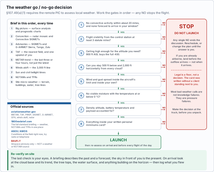
- Big picture. Surface analysis and prognostic charts. Where are the highs, lows and fronts, and which way are they moving? A front crossing your site during the shoot window changes everything downstream.
- Convection. Radar mosaic and the current Convective SIGMETs. Anything convective within about 20 miles and moving your way ends the discussion early.
- Advisories. SIGMETs, and G-AIRMET Sierra, Tango and Zulu. Tango in particular is often your answer before you have looked at anything else.
- TAF. The nearest reporting airport, and one upwind of you. Read the whole valid period, not only the initial group.
- METAR trend. Pull the last three or four hours, not only the latest report. Is the ceiling coming down? Is the temperature/dew point spread closing? Is the peak wind in the remarks climbing?
- Winds aloft. The 3,000 ft line for the direction and strength the surface wind will trend toward as the day mixes.
- Sun and civil twilight times, if the job runs near either end of the day.
- NOTAMs and TFRs. Weather is not the only thing that can cancel a flight, and this is the step people skip.
- Site micro-weather. Terrain, buildings, water, tree lines, canopy. Nothing in any product describes the air within 400 feet of your specific launch point — that judgment is yours, and Lesson 3.6 is how you make it.
The legal floor
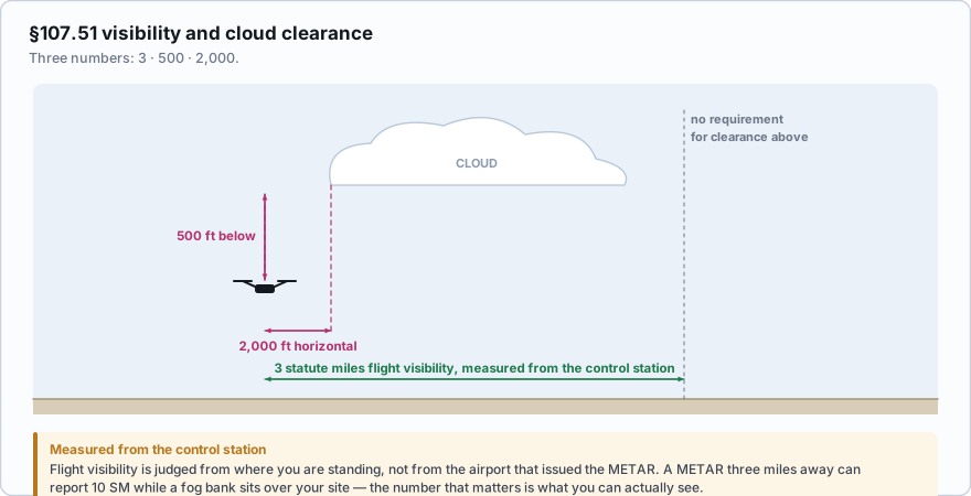
- 3 statute miles minimum flight visibility, as observed from the location of the control station
- 500 feet below the cloud
- 2,000 feet horizontally from the cloud
- There is no 'distance above the cloud' requirement in Part 107. That is a manned VFR rule under 91.155 and it is one of the most frequently chosen wrong answers on this exam
- The same section also caps you at 400 ft AGL and 87 knots (100 mph) groundspeed
The four-part manned VFR cloud clearance in Class E below 10,000 feet is '3 statute miles, 500 below, 1,000 above, 2,000 horizontal.' Part 107 keeps three of those numbers and drops the 1,000 above entirely. If an answer choice offers you a distance above the cloud, it is describing 91.155, not 107.51.
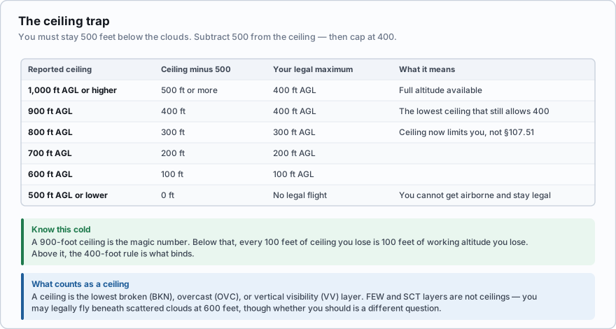
| Reported ceiling (AGL) | Maximum legal altitude (AGL) |
|---|---|
| 900 ft or higher | 400 ft — the full Part 107 limit |
| 800 ft | 300 ft |
| 700 ft | 200 ft |
| 600 ft | 100 ft |
| 500 ft or lower | No usable altitude remains |
The number to carry out of this table is 900. A 900-foot AGL ceiling is the lowest reported ceiling that still lets you use the whole 400 feet Part 107 allows. Below 900, subtract 500 from the ceiling and that is your roof.
One refinement that catches people in hilly country: a reported ceiling is height above the reporting station. Cloud bases follow a roughly constant height above sea level, not above the ground. If your job site sits 300 feet higher than the airport that issued the report, the cloud is about 300 feet lower over your head than the METAR suggests.
The nearest airport reports BKN009 and 4SM. Your site is at the same elevation. What can you legally do?
- Nothing — the visibility is below the Part 107 minimum
- Fly up to 400 ft AGL, since the ceiling is 900 ft and the visibility is above 3 SM
- Fly up to 900 ft AGL, since the cloud clearance requirement does not apply below the ceiling
Answer: B. 4 SM exceeds the 3 SM minimum. A 900 ft ceiling minus the required 500 ft below-cloud clearance leaves exactly 400 ft, which is also the Part 107 altitude limit. 900 ft is the lowest ceiling that still gives you the full 400.
Section 107.51 is one of the sections the FAA may waive under 107.205, along with 107.25, 107.29(a)(2) and (b), 107.31, 107.33, 107.35, 107.37(a), 107.39, 107.41 and 107.145. In practice a visibility or cloud-clearance waiver is rare and demands a serious mitigation case. Assume you are flying to the published numbers.
Personal minimums
The legal minimums are a floor, not a plan. A 3 SM visibility with a 900 ft ceiling and 20-knot gusts is legal and is a bad idea. Personal minimums are the numbers you decide on in advance, in a quiet room, and write down — so that the decision is already made before a client is standing next to you asking how long this is going to take.
Adjust these to your aircraft, your experience, and the job. The point is that they exist in writing, not that these particular numbers are right for you. Wind: sustained 18 mph or less, gusts no more than 8 mph above sustained Ceiling: 1,500 ft AGL or higher Visibility: 5 SM or better Temperature: above 3 °C, and no visible moisture within 5 °C of freezing Convection: no cell within 25 miles, and none forecast to arrive within the flight window Precipitation: none, of any intensity Density altitude: if above 6,000 ft, reduce payload and cut planned flight time by a third Review: revisit the card every six months, and after any flight that felt uncomfortable
Raise the numbers when the situation is harder than usual: an unfamiliar site, a new aircraft, a solo operation with no visual observer, flight over water, work near people, or a day when you are tired. Lower them only after you have logged flights that justify it.
The part that is about you, not the weather
Most bad weather decisions in commercial drone work are not knowledge failures. They are pressure failures. You drove two hours. The crane is only on site today. The client rescheduled once already and made a comment about it. That pressure has a name in aviation — mission completion pressure, or in its older form, get-there-itis — and Module 5 covers the hazardous attitudes behind it in detail.
The defense is structural. Make the decision at the truck, before you unpack, against a written card. Tell the client at booking that weather may move the date, so that the conversation has already happened. And give yourself an explicit out: 'if the ceiling is below X when I arrive, I pack up and we reschedule' is a much easier sentence to say when you rehearsed it the night before.
- A briefing describes the past and a forecast; the sky in front of you is the present.
- On arrival, look for: cloud base and trend, the windsock or flags or tree tops, dust and water surface texture, temperature against your expectation, and anything building on the horizon.
- Re-assess before every flight of the day, not only the first one. A four-hour job spans a lot of atmosphere.
- Log the weather you flew in. It is your evidence if anything goes wrong, and over a season it is the only honest data you will ever have for setting your own minimums.
You have driven 90 minutes to a real estate shoot. On arrival the ceiling is clearly lower than the 1,500 ft on your personal minimums card, though it is still legal. The agent is waiting. What is the correct action?
- Fly, because the conditions are legal and the client is present
- Fly at a reduced altitude to compensate for the lower ceiling
- Do not fly, and reschedule — the card exists precisely for this moment
Answer: C. Personal minimums are worth nothing if they only apply when nobody is watching. The card was written without commercial pressure and with a clear head; the moment on site is the moment it is meant to protect you from. Legal is a floor, not a decision.
- Section 107.49(a)(1) requires the remote PIC to assess local weather conditions as part of the preflight assessment of the operating environment
- aviationweather.gov and 1800wxbrief.com (or 1-800-WX-BRIEF) are the official sources; B4UFLY is an airspace advisory tool and not a weather or NOTAM source
- Brief in a fixed order: synoptic picture, convection, advisories, TAF, METAR trend, winds aloft, twilight times, NOTAMs and TFRs, then site micro-weather
- Section 107.51 requires 3 SM flight visibility from the control station, 500 ft below cloud and 2,000 ft horizontally — there is no above-the-cloud requirement in Part 107
- A 900 ft AGL ceiling is the lowest that still permits the full 400 ft AGL; below that, maximum altitude equals the ceiling minus 500 ft
- Personal minimums are stricter than the legal floor, are written down in advance, and are raised for unfamiliar sites, new aircraft, or a tired pilot
- Re-assess on arrival and before every flight of the day, and log the conditions you actually flew in