Track your progress, take practice exams, and study the flashcards in the app.
3.8 Reading a METAR, Field by Field
- Decode every field of a METAR in the order they appear
- Identify the ceiling and the flight visibility in any observation
- Read the present-weather codes, including the two different meanings of the letter M
- Describe what ASOS and AWOS measure, how to reach them, and where they fall short
A METAR is an observation: what the weather is doing right now at one specific point on the ground. It is not a forecast. The name comes from the French for aviation routine weather report, and the format is international, which is why it looks like a license plate. Once you know the field order it decodes in about ten seconds, and you will read one before every commercial flight you ever make.
METARs are issued hourly, usually between 55 and 59 minutes past the hour. When conditions change significantly between hourly reports — the visibility drops, a thunderstorm starts, the ceiling falls through a threshold — a SPECI is issued off-cycle. A SPECI uses exactly the same format.
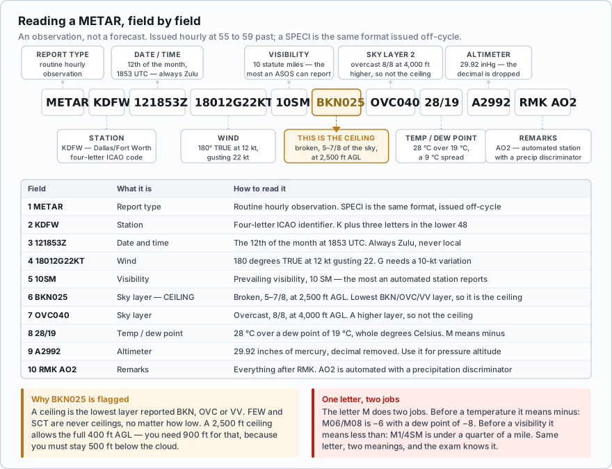
The fields, in order
| # | Field | Example | How to read it |
|---|---|---|---|
| 1 | Report type | METAR / SPECI | Routine hourly, or a special issued because conditions changed |
| 2 | Station identifier | KDSM | Four-letter ICAO code. K plus three letters in the lower 48, PA in Alaska, PH in Hawaii |
| 3 | Date and time | 141953Z | 14th day of the month, 1953 UTC. Always Zulu, never local |
| 4 | Modifier | AUTO or COR | AUTO = fully automated with no human input. COR = a corrected report. No modifier = a human observer was involved |
| 5 | Wind | 15012G22KT | Direction 150 true, 12 knots, gusting 22. 00000KT is calm. VRB means variable direction |
| 6 | Visibility | 7SM | Prevailing visibility in statute miles. M in front means *less than*. 10SM is the most an automated station reports |
| 7 | RVR (if any) | R04R/2400FT | Runway visual range for runway 04R, 2,400 ft. Rarely relevant to drone work |
| 8 | Present weather | -RA BR | Intensity, then descriptor, then phenomenon. Full table below |
| 9 | Sky condition | SCT008 BKN012 | Coverage plus height in hundreds of feet AGL above the station |
| 10 | Temperature / dew point | 09/07 | Whole degrees Celsius. M in front means *minus* |
| 11 | Altimeter | A2984 | Inches of mercury with the decimal removed: 29.84 |
| 12 | Remarks | RMK AO2 | Everything after RMK. Station type, sea level pressure, peak wind, precise temperatures, and more |
The wind group has three rules people miss
- Wind direction is referenced to true north, not magnetic. Spoken winds from a tower, ATIS or AWOS voice broadcast are magnetic.
- VRB replaces the direction only when the wind speed is 6 knots or less and the direction is varying.
- A gust (the G group) is reported when the variation between peaks and lulls is 10 knots or more.
- A variable direction group like 120V190 is added when the speed is more than 6 knots and the direction varies by 60 degrees or more.
- 00000KT is calm. Speeds are in knots unless the group ends in MPS or KMH.
The present weather codes
Present weather is built like a small sentence: an intensity or proximity qualifier, then a descriptor, then the phenomenon itself. +TSRA is a heavy thunderstorm with rain. -SHSN is light snow showers. VCFG is fog in the vicinity of the station but not at it. This is the complete table.
| Group | Code | Meaning |
|---|---|---|
| Intensity | - | Light |
| Intensity | (no sign) | Moderate |
| Intensity | + | Heavy |
| Proximity | VC | In the vicinity — between 5 and 10 SM of the station, not at it |
| Descriptor | MI | Shallow |
| Descriptor | PR | Partial |
| Descriptor | BC | Patches |
| Descriptor | DR | Low drifting |
| Descriptor | BL | Blowing |
| Descriptor | SH | Shower(s) |
| Descriptor | TS | Thunderstorm |
| Descriptor | FZ | Freezing |
| Precipitation | DZ | Drizzle |
| Precipitation | RA | Rain |
| Precipitation | SN | Snow |
| Precipitation | SG | Snow grains |
| Precipitation | IC | Ice crystals |
| Precipitation | PL | Ice pellets |
| Precipitation | GR | Hail |
| Precipitation | GS | Small hail or snow pellets |
| Precipitation | UP | Unknown precipitation (automated stations only) |
| Obscuration | BR | Mist — visibility 5/8 to 6 SM |
| Obscuration | FG | Fog — visibility less than 5/8 SM |
| Obscuration | FU | Smoke |
| Obscuration | VA | Volcanic ash |
| Obscuration | DU | Widespread dust |
| Obscuration | SA | Sand |
| Obscuration | HZ | Haze |
| Obscuration | PY | Spray |
| Other | PO | Dust or sand whirls (dust devils) |
| Other | SQ | Squalls |
| Other | FC | Funnel cloud; +FC is a tornado or waterspout |
| Other | SS | Sandstorm |
| Other | DS | Duststorm |
The letter M does two entirely different jobs. In front of the temperature it means minus: M06/M08 is minus 6 with a dew point of minus 8. In front of the visibility it means less than: M1/4SM is less than a quarter of a mile. Same letter, different meaning, and the exam knows it.
A METAR contains the group 08004KT M1/4SM FZFG M03/M03. What is the visibility?
- One quarter of a statute mile
- Less than one quarter of a statute mile
- Minus one quarter, meaning the sensor has failed
Answer: B. Before a visibility value, M means 'less than'. Before a temperature it means 'minus' — which is what the M03/M03 group is doing in the same report. One letter, two jobs.
Sky condition and the ceiling
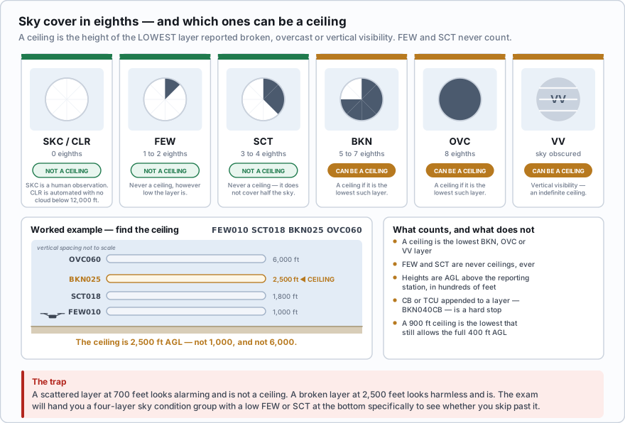
| Code | Coverage | Is it a ceiling? |
|---|---|---|
| SKC | Sky clear — a manual observation with no cloud at all | No |
| CLR | Clear — an automated observation with no cloud detected below 12,000 ft | No |
| FEW | 1 to 2 eighths | No |
| SCT | 3 to 4 eighths | No |
| BKN | 5 to 7 eighths | Yes, if it is the lowest such layer |
| OVC | 8 eighths | Yes, if it is the lowest such layer |
| VV | Sky obscured — the number is vertical visibility | Yes — an indefinite ceiling |
CB or TCU may be appended to a layer — BKN040CB is a broken layer at 4,000 feet containing cumulonimbus. Treat that as a hard stop, not a detail. The difference between SKC and CLR is also tested: SKC comes from a human looking at the sky, CLR comes from a machine that can only see straight up and only to 12,000 feet.
Four worked METARs
METAR KJFK 121853Z 18004KT 10SM FEW048 24/12 A3002 Routine report, John F. Kennedy International, 12th at 1853Z. Wind 180 true at 4 knots. Visibility 10 statute miles or more. Few clouds at 4,800 ft — no ceiling, because FEW is never a ceiling. Temperature 24 °C, dew point 12 °C. Altimeter 30.02. Note the spread: 24 − 12 = 12 °C, and 12 ÷ 2.5 = 4.8, which predicts a cloud base near 4,800 ft. The observation agrees. Part 107 read: legal on visibility, no ceiling restriction, negligible wind. Go.
METAR KMDW 121856Z AUTO 32005KT 1 1/2SM RA OVC007 06/04 A2990 RMK AO2 Routine report, Chicago Midway, 12th at 1856Z. AUTO — fully automated, no observer. Wind 320 true at 5 knots. Visibility 1 1/2 statute miles. RA — moderate rain. OVC007 — overcast at 700 ft AGL, and because it is the lowest broken-or-worse layer that is the ceiling. Temperature 6 °C, dew point 4 °C. Altimeter 29.90. AO2 means the automated station has a precipitation discriminator. Part 107 read: 1 1/2 SM is below the 3 SM minimum in 107.51. That alone ends it. Even if visibility improved, a 700 ft ceiling would cap you at 200 ft AGL. No-go.
METAR KDSM 141953Z 15012G22KT 120V190 7SM -RA SCT008 BKN012 OVC030 09/07 A2984 RMK AO2 Des Moines, 14th at 1953Z. Wind 150 true at 12 knots gusting 22 — the gust group appears because the 10-knot spread meets the reporting threshold. 120V190 — the direction is swinging between 120 and 190; this group appears because the speed exceeds 6 knots and the variation is at least 60 degrees. Visibility 7 SM. -RA light rain. Scattered at 800, broken at 1,200, overcast at 3,000. Temperature 9 °C, dew point 7 °C. Altimeter 29.84. The ceiling is 1,200 ft AGL — the lowest BKN layer. The SCT008 is a distraction. Part 107 read: visibility is legal. A 1,200 ft ceiling allows the full 400 ft AGL, since you need only 900. But 22-knot gusts swinging through 70 degrees of direction is a hard no-go for a small multirotor. Legal and unwise are different questions.
SPECI KFAR 231947Z AUTO VRB04KT M1/4SM +SN FZFG VV001 M08/M09 A2971 RMK AO2 SPECI — issued off the hour because conditions changed sharply. Fargo, 23rd at 1947Z, automated. VRB04KT — direction variable at 4 knots; VRB is permitted because the speed is 6 knots or less. M1/4SM — less than a quarter mile. +SN heavy snow. FZFG freezing fog. VV001 — sky obscured, vertical visibility 100 ft, which counts as an indefinite ceiling of 100 ft. Temperature minus 8, dew point minus 9. Altimeter 29.71. Part 107 read: no. And note the icing setup — visible moisture plus a temperature well below zero is both requirements met.
In the sky condition group SCT007 BKN019 OVC045, what is the ceiling?
- 700 ft AGL
- 1,900 ft AGL
- 4,500 ft AGL
Answer: B. The ceiling is the lowest layer reported as broken, overcast, or vertical visibility. SCT007 is scattered and therefore not a ceiling, no matter how low it is. BKN019 is the lowest broken layer, so the ceiling is 1,900 ft AGL.
Where METARs come from: ASOS and AWOS
The observation you are reading was almost certainly produced by an automated station. There are two families, and the exam expects you to know the difference.
- ASOS — the Automated Surface Observing System. Operated jointly by the National Weather Service, the FAA, and the Department of Defense, it is the primary surface weather network in the United States and the main source of hourly METARs. It samples continuously and updates its observation every minute.
- AWOS — the Automated Weather Observing System. Owned by the FAA, states, or airports themselves, and built in tiers depending on what sensors were paid for.
| Type | Reports |
|---|---|
| AWOS-A | Altimeter setting only |
| AWOS-AV | Altimeter and visibility |
| AWOS-1 | Altimeter, wind, temperature, dew point, and density altitude |
| AWOS-2 | AWOS-1 plus visibility |
| AWOS-3 | AWOS-2 plus cloud and ceiling |
| AWOS-3P / 3T / 3PT | AWOS-3 plus precipitation identification, thunderstorm and lightning detection, or both |
| AWOS-4 | AWOS-3 plus precipitation type and accumulation, freezing rain, thunderstorm, and runway surface sensors |
- Both ASOS and AWOS broadcast a 20 to 30 second message, updated every minute, over a discrete VHF frequency or a navaid voice channel.
- Nominal reception is up to 25 nautical miles from the site and up to 10,000 feet AGL.
- Most sites also have a telephone number you can call — the fastest weather check there is when you are standing in a field.
- The frequency and phone number are printed in the airport data block on a sectional chart and in the Chart Supplement.
- An AWOS will announce density altitude whenever it exceeds the field elevation by more than 1,000 feet.
- In the remarks, AO1 means the station has no precipitation discriminator; AO2 means it has one and can tell rain from snow.
An automated station sees a narrow cone directly above itself. It can report CLR while a solid deck sits two miles away, and it cannot report any visibility above 10 SM. Your job site may be five or ten miles from that sensor, over different terrain, with a different surface. The METAR is evidence, not truth. Section 107.51 asks for flight visibility as observed from your control station — that is your eyes, not the machine's.
The remarks section rewards a little curiosity. SLP132 is sea level pressure 1013.2 hPa. PK WND 26038/1917 is a peak wind of 38 knots from 260 at 1917Z — often the single most useful line in the report for a drone pilot. T00560039 gives temperature and dew point to a tenth of a degree, which is far more precise than the 06/04 in the body and much better for judging how fast the spread is closing. WSHFT 1852 records the time of a wind shift, which is how you confirm a front went through.
- A METAR is an hourly observation, not a forecast; a SPECI is the same format issued off-cycle when conditions change
- Fields run in fixed order: type, station, date/time, modifier, wind, visibility, RVR, present weather, sky condition, temperature/dew point, altimeter, remarks
- METAR winds are true north referenced, VRB requires 6 knots or less, gusts are reported at a 10-knot variation, and a variable direction group needs more than 6 knots and at least 60 degrees
- M means minus before a temperature and less than before a visibility
- BR is mist at 5/8 to 6 SM and FG is fog below 5/8 SM; the ceiling is the lowest BKN, OVC or VV layer and FEW and SCT never count
- CLR is automated with no cloud detected below 12,000 ft; SKC is a human observation of a clear sky
- ASOS and AWOS update every minute and broadcast about 25 NM and up to 10,000 ft AGL, but they only see the air directly above the sensor