Track your progress, take practice exams, and study the flashcards in the app.
3.6 Wind, Turbulence and Micrometeorology for Small Drones
- Explain why the reported surface wind understates the wind at your operating altitude
- Identify mechanical and thermal turbulence sources on a typical job site
- Recognize wind shear situations and describe what each does to a small unmanned aircraft
- Build wind into flight planning through route order, battery reserve, and personal minimums
Wind is the weather factor you will actually contend with on almost every job. Thunderstorms cancel a handful of flights a year. Wind shapes every single one — how long the battery lasts, whether the camera holds still, which direction you launch, and whether the aircraft comes home.
The exam covers wind at a fairly high level. This lesson covers that material and then goes further, because the layer you fly in — the bottom 400 feet — is the most poorly described layer in all of aviation weather, and no product forecasts it directly.
Where wind comes from
Air moves from higher pressure toward lower pressure. The strength of the push is the pressure gradient: on a surface analysis chart, the closer the isobars — the lines of equal pressure — the stronger the wind. Coriolis deflection turns that flow to the right in the Northern Hemisphere until, well above the ground, the wind ends up blowing roughly parallel to the isobars rather than across them.
Near the ground, friction breaks that balance. Trees, buildings, and terrain drag on the moving air, slowing it and letting it turn back toward the low pressure. The practical consequence is the single most useful piece of wind knowledge a drone pilot can have.
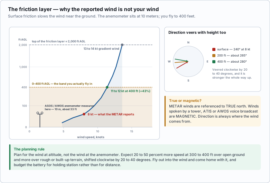
- The friction layer runs from the surface to roughly 2,000 ft AGL. Within it, wind speed increases with height and direction veers (shifts clockwise) with height.
- ASOS and AWOS anemometers measure at 10 meters — about 33 feet.
- As a planning rule of thumb, expect the wind at 300 to 400 ft AGL to be noticeably stronger than reported — commonly 20 to 50 percent stronger over open ground, and more over rough or built-up terrain — and shifted clockwise by 20 to 40 degrees.
- METAR winds are referenced to true north. Winds spoken by a tower, ATIS, or AWOS voice broadcast are referenced to magnetic north.
- Wind direction is always the direction the wind is coming from.
The AWOS at the field reports wind 240 at 8 knots. What should you plan for at 350 ft AGL?
- The same, 240 at 8 knots, since wind is uniform below 400 feet
- Stronger than 8 knots and shifted clockwise from 240
- Weaker than 8 knots, because friction increases with height
Answer: B. The anemometer is at 10 meters. Friction slows and backs the wind near the surface, so climbing out of the friction layer means the wind gets stronger and veers clockwise. Planning for the reported number is the classic way to run out of battery on the return leg.
Wind shear
Wind shear is any change in wind speed or direction over a short distance. It can be vertical or horizontal, and it can occur at any altitude. Below 2,000 ft AGL it is called low-level wind shear (LLWS), and that is the entire band you work in.
- Frontal shear — the wind on either side of a front differs sharply in speed and direction
- Thunderstorm outflow and microbursts — the most violent shear there is (Lesson 3.4)
- Temperature inversions — a calm surface layer with fast-moving air right on top of it (Lesson 3.2)
- Terrain and structures — the topic of the rest of this lesson
Shear is dangerous to a small aircraft because the flight controller reacts to it after the fact. It measures attitude and position, notices the error, and corrects. In a sharp shear the correction arrives while the aircraft is already somewhere else, so you get overshoot, oscillation, and in the worst case a departure from controlled flight. It is also why an aircraft can hold position perfectly at 100 feet and become unmanageable at 250.
Mechanical turbulence
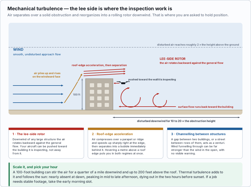
Mechanical turbulence is what happens when moving air runs into something solid — a building, a hangar, a tree line, a ridge, a stack of shipping containers. The airflow separates, breaks up into eddies, and reorganises into a rolling rotor on the downwind (lee) side. The stronger the wind and the rougher the obstruction, the more violent the eddies.
As a planning rule of thumb, treat the disturbed air as extending downwind about 10 to 20 times the height of the obstruction, and up to roughly twice its height above the ground. A 100-foot building can stir the air for a quarter mile downwind and up to 200 feet above the roof.
Three specific patterns account for most of the trouble on real job sites:
- The lee-side rotor. Downwind of any large structure the air rotates backward against the general flow. Your aircraft can be pushed toward the building it is inspecting, not away from it. This is the situation that puts drones into walls.
- Roof-edge acceleration. Air compresses as it goes over a parapet or ridge line and speeds up sharply right at the edge, then separates into a bubble immediately behind it. Hovering a meter above a roof edge puts you in both regimes at once.
- Channelling between structures. A gap between two buildings, or a street between rows of them, acts as a venturi. Wind funnelling through can be far stronger than the wind in the open, with no warning from anything you can see.
You are inspecting the east face of a warehouse. The wind is from the west at 15 knots. Where is the turbulence worst?
- On the west face, where the wind hits the building first
- On the east face, in the rotor on the downwind side
- Directly above the roof, where the wind is fastest
Answer: B. The lee side — downwind of the obstruction — is where the airflow separates and forms a rolling rotor. With a west wind, the east face is the lee side. It is also the face where the rotor can push the aircraft toward the wall rather than away from it.
Thermal turbulence and the time of day
Convective (thermal) turbulence comes from uneven surface heating. Dark, dry surfaces — asphalt, bare soil, rooftops, a plowed field — heat quickly and launch rising columns of air. Water, forest, and irrigated crops stay cooler and have compensating downdrafts over them. Crossing the boundary between the two on a sunny afternoon gives you a distinct bump.
Thermal turbulence follows the sun. It is nearly absent at dawn, builds through the morning, peaks in the mid to late afternoon, and dies out in the two hours before sunset. If you have a choice about when to fly a job that needs stable footage, take the early morning slot. Smooth air, low sun angle, better light, and no thermals — and the client will think you are a better pilot than you are.
Turbulence intensity is reported in four levels — light, moderate, severe, and extreme — with chop used for rhythmic bumpiness that does not change altitude or attitude appreciably. Frequency is reported as occasional (less than one third of the time), intermittent (one third to two thirds), or continuous. Those terms come from the AIM and are how turbulence is described in a PIREP.
Terrain and local circulations
- Mountain and ridge flow. Wind crossing a ridge produces an updraft on the windward side and a downdraft on the lee side that can exceed a small aircraft's climb rate. Cross ridges at about a 45-degree angle so you can turn away quickly if you meet sink.
- Mountain waves. Stable air crossing a ridge at speed sets up standing waves downwind, sometimes with violent rotors underneath them. Standing lenticular clouds — smooth, lens-shaped, and stationary while the wind rips past — are the visual marker. They indicate strong wave activity and severe turbulence beneath.
- Sea and lake breezes. During the day land heats faster than water, so air flows onshore; at night it reverses and flows offshore as a land breeze. The leading edge of a sea breeze is a convergence line and can trigger thunderstorms.
- Valley drainage winds. After sunset, cooled air flows downhill and down-valley (a katabatic or drainage wind). By day the flow reverses and runs upslope. This is why a canyon site can be dead calm at 3 p.m. and blowing 15 knots at 7 p.m.
Making it operational
- Fly out into the wind, come home with it. Never let the outbound leg be the easy one. A tailwind out and a headwind back is how aircraft land in fields.
- Gusts matter more than steady wind. A reported 10G22 is a harder flight than a steady 18, because each gust is a shear event the controller has to chase. When you write personal minimums, set a gust spread limit as well as a speed limit.
- Know your aircraft's number and treat it as a limit, not a target. Folding consumer quadcopters are commonly rated for wind resistance in the low twenties of knots. That figure is where the manufacturer says the aircraft stops being controllable, not where flying stops being sensible.
- Watch for the attitude limit. When the wind exceeds the tilt the aircraft is allowed to command, it stops holding position and starts drifting downwind while telling you it is trying. That is a weather-induced fly-away, and the correct response is to descend immediately into slower air and land, not to fight it upwind at altitude.
- Budget the battery for the wind, not the distance. Holding station against 15 knots costs real power. Add reserve; do not assume the manufacturer's endurance figure, which was measured hovering in still air.
Two wording traps. First, wind direction is where the wind is coming from — a wind of 270 blows from the west toward the east. Second, METAR winds are true, spoken winds are magnetic. An FAA sample question gives a METAR with 18004KT and asks for the direction and velocity; the answer is 180 degrees true at 4 knots, not magnetic.
AIRMET Tango covers exactly the wind hazards in this lesson: moderate turbulence, sustained surface winds of 30 knots or more, and non-convective low-level wind shear. If Tango is active over your area, the surface wind alone will usually have already made your decision for you.
- Wind flows from high to low pressure, deflected clockwise by the Coriolis effect; closer isobars mean stronger wind
- Within the friction layer (surface to about 2,000 ft AGL) wind speed increases and direction veers with height, so the reported wind understates conditions at 300 to 400 ft
- Reported winds are measured at 10 meters; METAR winds are true north referenced, spoken winds are magnetic, and direction is where the wind comes from
- Mechanical turbulence forms a rotor on the lee side of obstructions and channels between them; the lee side is where inspection work usually puts you
- Thermal turbulence peaks in mid to late afternoon and is nearly absent at dawn and in the last two hours before sunset
- Wind shear below 2,000 ft AGL comes from fronts, thunderstorm outflow, inversions, and terrain, and small aircraft correct for it too slowly
- Fly out into the wind and return with it, treat gust spread as a limit, and budget battery for wind rather than distance