Track your progress, take practice exams, and study the flashcards in the app.
3.5 Fog, Icing, Ceiling and Visibility
- Distinguish the five fog types by the conditions each one needs to form
- State the two conditions required for structural icing and tell clear ice from rime ice
- Define ceiling correctly and identify it in any sky condition group
- Apply the Part 107 visibility and cloud clearance limits to a reported ceiling
This lesson covers the three conditions that ground more commercial drone flights than anything except wind: fog, ice, and a low ceiling. All three come from the same source — moisture in air that has been cooled to its saturation point — which is why they are taught together.
Fog is a cloud sitting on the ground
There is no meteorological difference between fog and a cloud. The difference is where the base is. In a surface observation, the code FG is used when visibility drops below 5/8 statute mile; between 5/8 and 6 statute miles the same phenomenon is reported as mist, coded BR. Those two thresholds are worth remembering because they appear on the exam in METAR decoding questions.
Fog needs the same three things any cloud needs: water vapor, condensation nuclei to condense onto, and cooling to the dew point. The five named fog types are five different ways of arranging that cooling. Learn them by their formation conditions, because that is how questions are worded.
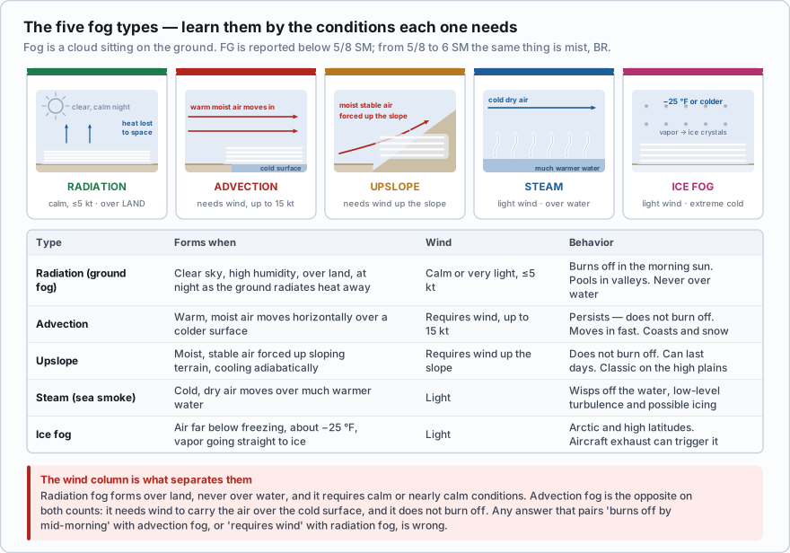
| Type | Forms when | Wind | Behavior |
|---|---|---|---|
| Radiation (ground fog) | Clear sky, high humidity, over land, at night as the ground radiates its heat away | Calm or very light — up to about 5 kt | Burns off as the sun warms the ground. Pools in valleys and low ground. Never forms over water. |
| Advection | Warm, moist air moves horizontally over a colder surface | Requires wind, up to about 15 kt. Above 15 kt it lifts into low stratus | Persists — it does not burn off. Moves in fast. Common on coasts and over snow-covered ground. |
| Upslope | Moist, stable air is forced up sloping terrain and cools adiabatically | Requires wind to push the air upslope | Does not burn off. Can last for days. Classic on the high plains east of the Rockies. |
| Steam (sea smoke) | Cold, dry air moves over much warmer water | Light | Wisps rising off the water. Comes with low-level turbulence and possible icing. |
| Ice fog | Air far below freezing — roughly −25 °F or colder — with vapor turning straight into ice crystals | Light | Arctic and high-latitude conditions. Aircraft exhaust can trigger it. |
One more worth knowing: precipitation-induced fog, where warm rain falls through cooler air near the surface, saturates it, and fogs it in. It shows up ahead of warm fronts and it is why a warm-frontal drizzle so often comes with a quarter mile of visibility.
Radiation fog forms over land, never over water, and it requires calm or nearly calm conditions. Advection fog is the opposite on both counts: it needs wind to carry the air over the cold surface, and it does not burn off. A question that pairs 'burns off by mid-morning' with advection fog, or pairs 'requires wind' with radiation fog, is wrong.
A layer of fog rolls in off the ocean over a coastal construction site on a 12-knot onshore breeze and is still there at 2 p.m. What type is it?
- Radiation fog
- Advection fog
- Upslope fog
Answer: B. Warm moist marine air moving horizontally over a colder surface is advection fog. It requires wind (up to about 15 kt), and unlike radiation fog it persists rather than burning off in the morning sun.
Structural icing
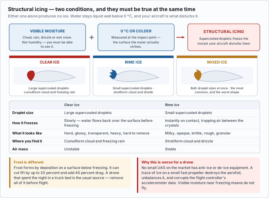
- Visible moisture — cloud, rain, drizzle, or wet snow. Not humidity; you have to be able to see it.
- A temperature of 0 °C or colder at the impact point — the surface the water hits.
- Both, at the same time. Either one alone produces no structural ice.
- Water can remain liquid well below 0 °C. These supercooled droplets freeze the instant something disturbs them, which is exactly what your aircraft does.
| Clear ice | Rime ice | |
|---|---|---|
| Droplet size | Large supercooled droplets | Small supercooled droplets |
| How it freezes | Slowly — water flows back over the surface before freezing | Instantly on contact, trapping air between the crystals |
| What it looks like | Hard, glossy, transparent, heavy, hard to remove | Milky, opaque, brittle, rough, granular |
| Where you find it | Cumuliform cloud and freezing rain | Stratiform cloud and drizzle |
| Air mass | Unstable | Stable |
Mixed ice is exactly what it sounds like — both types at once, when droplet sizes vary. Frost is different again: it forms by deposition directly onto a surface that is below freezing when the dew point of the surrounding air is also below freezing. Frost does not change the shape of an airfoil much, but it roughens it, and the FAA's published figures are that frost can reduce lift by as much as 30 percent and increase drag by 40 percent. Any frost on your propellers or airframe must be removed before flight, and a drone that spent the night in a truck bed is the most common way to find some.
Freezing rain deserves its own warning. Rain that is liquid but below freezing means there is a layer of warmer air above you — the classic warm-front setup where rain forms aloft and falls into subfreezing air near the surface. It produces the fastest ice accumulation there is.
Now the drone-specific part, and it is worse than most students expect. Your propellers are small, thin, and turning fast, which means a trace of ice that a light airplane would shrug off destroys their airfoil. Ice adds mass asymmetrically, so the props go out of balance and the vibration corrupts the flight controller's accelerometer data. Thrust falls, current draw rises, and the battery — already weakened by cold — sags. No small UAS on the market has anti-ice or de-ice equipment. If there is visible moisture and the temperature is anywhere near freezing, the correct decision is not to fly.
The outside air temperature is −4 °C, the sky is clear, the visibility is 20 miles, and the relative humidity is 65 percent. Is structural icing a hazard?
- Yes, because the temperature is below freezing
- Yes, because the relative humidity is above 50 percent
- No, because there is no visible moisture
Answer: C. Icing requires visible moisture AND 0 °C or colder at the impact point. Cold, clear air with no cloud, rain or drizzle has nothing to freeze onto the aircraft. Relative humidity is not visible moisture.
Ceiling — the definition people get wrong
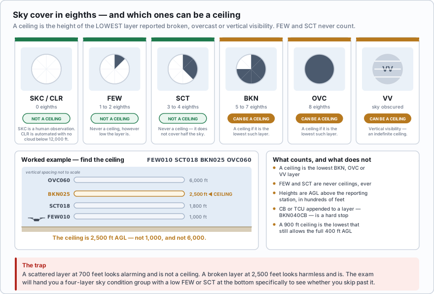
- A ceiling is the height above ground of the lowest layer reported as broken (BKN), overcast (OVC), or vertical visibility (VV).
- FEW and SCT are not ceilings. Ever. Neither one covers more than half the sky.
- Sky cover is reported in eighths of the sky: FEW = 1 to 2, SCT = 3 to 4, BKN = 5 to 7, OVC = 8.
- VV means the sky is obscured and the number is how far you can see straight up — an indefinite ceiling.
- Cloud heights in a METAR are AGL above the reporting station, in hundreds of feet.
Sky condition group: FEW010 SCT018 BKN025 OVC060 FEW010 — 1 to 2 eighths at 1,000 ft. Not a ceiling. SCT018 — 3 to 4 eighths at 1,800 ft. Not a ceiling. BKN025 — 5 to 7 eighths at 2,500 ft. This is the ceiling: 2,500 ft AGL. OVC060 — overcast at 6,000 ft. A higher layer, so not the ceiling. The ceiling is 2,500 feet AGL, not 1,000 and not 6,000.
A scattered layer at 700 feet looks alarming and is not a ceiling. A broken layer at 2,500 feet looks harmless and is. The exam will hand you a four-layer sky condition group with a low FEW or SCT on the bottom specifically to see whether you skip past it.
Visibility, and what it means for you
A surface observation reports prevailing visibility — the greatest distance that can be seen through at least half the horizon circle, measured at the station, in statute miles. Automated stations top out at 10SM and cannot report anything further. What Part 107 requires of you is different: flight visibility as observed from the location of the control station. No observation reports that number. You determine it, and you are responsible for it.
The minimum flight visibility, as observed from the location of the control station, may not be less than 3 statute miles. The minimum distance from clouds must be no less than 500 feet below the cloud and 2,000 feet horizontally from the cloud.
There is no distance-above-the-cloud requirement anywhere in Part 107. That rule belongs to manned VFR flight under 91.155, and it is one of the most commonly chosen wrong answers on this exam.
Forecasters and briefing tools sort conditions into four flight categories, and you will see them color-coded on every weather map and app you use.
| Category | Ceiling | Visibility | Color |
|---|---|---|---|
| VFR | Greater than 3,000 ft AGL | and greater than 5 SM | Green |
| MVFR (marginal) | 1,000 to 3,000 ft AGL | and/or 3 to 5 SM | Blue |
| IFR | 500 to less than 1,000 ft AGL | and/or 1 to less than 3 SM | Red |
| LIFR (low IFR) | Below 500 ft AGL | and/or less than 1 SM | Magenta |
Note where the Part 107 visibility floor of 3 SM sits: right on the IFR boundary. If a station is reporting IFR conditions on visibility, you are already below the legal minimum before you consider anything else. MVFR is your marginal band, and it is where most bad drone weather decisions get made.
The ceiling trap
Put the 500-feet-below-cloud rule together with the 400 ft AGL altitude limit and a piece of arithmetic falls out that catches almost everyone the first time.
- To use the full 400 ft AGL allowed by 107.51 while staying 500 ft below the cloud, you need a ceiling of at least 900 ft AGL.
- 900 ft AGL is the lowest reported ceiling that still permits operation all the way to 400 ft AGL.
- Below that, your maximum legal altitude is the ceiling minus 500 feet. An 800 ft ceiling caps you at 300 ft AGL. A 700 ft ceiling caps you at 200 ft AGL.
- At a 500 ft ceiling there is no legal altitude left at all.
- Remember that a reported ceiling is AGL above the reporting station. If your site sits 300 feet higher than the airport, the cloud is 300 feet lower over you.
The nearest airport reports OVC008. What is the highest you may legally fly, assuming your site is at the same elevation as the airport?
- 400 ft AGL
- 300 ft AGL
- 800 ft AGL
Answer: B. An 800 ft overcast is a ceiling of 800 ft AGL. Section 107.51 requires 500 ft of clearance below the cloud, so 800 − 500 = 300 ft AGL is your limit. You only get the full 400 ft when the ceiling is 900 ft or higher.
Obstructions to visibility that are not fog also matter to a camera operator: haze (HZ), smoke (FU), blowing dust (BLDU), and blowing sand (BLSA) all reduce contrast long before they reduce reported visibility below 3 miles. Wildfire smoke in particular can be legally flyable and commercially useless, and it will also foul motor bearings and camera glass faster than you would expect.
- Fog is cloud at the surface: FG is reported below 5/8 SM visibility and BR (mist) from 5/8 to 6 SM
- Radiation fog needs clear calm nights over land and burns off; advection fog needs wind up to 15 kt over a colder surface and persists; upslope fog needs wind and does not burn off; steam fog is cold air over warm water; ice fog needs extreme cold
- Structural icing requires visible moisture AND 0 °C or colder at the impact point — both, at the same time
- Clear ice comes from large droplets, cumuliform cloud and freezing rain; rime ice comes from small droplets and stratiform cloud
- A ceiling is the lowest BKN, OVC or VV layer; FEW and SCT are never ceilings
- Part 107 requires 3 SM flight visibility from the control station, 500 ft below cloud and 2,000 ft horizontally — with no above-the-cloud requirement
- A 900 ft AGL ceiling is the lowest that still allows the full 400 ft AGL; below that your limit is the ceiling minus 500 feet