Track your progress, take practice exams, and study the flashcards in the app.
3.4 Thunderstorms, Microbursts, Lightning, Hail and Tornadoes
- List the three ingredients a thunderstorm requires and recognize when all three are present
- Identify the three stages of a thunderstorm cell and the defining characteristic of each
- Describe microburst geometry and explain why it is unsurvivable for a small unmanned aircraft
- State the avoidance distances and apply them to a real go/no-go decision
A thunderstorm is the most concentrated collection of aviation hazards that exists: severe turbulence, severe icing, hail, lightning, extreme up- and downdrafts, sudden wind shear, heavy precipitation, and tornadoes, all in one place. Airliners avoid them. Your three-pound aircraft has no business anywhere near one, and the FAA tests this area hard. The good news is that storms are also the most predictable hazard here: they need three specific things, and if any one is missing you get no storm.
The three ingredients
- Sufficient water vapor — moisture to condense and to release latent heat
- An unstable lapse rate — air that keeps rising once it is started
- A lifting action — something to start it: surface heating, terrain, a front, or converging winds
- All three, every time. Two out of three gives you a nice cumulus day and nothing more.
This is why afternoon thunderstorms are a summer phenomenon in humid regions and why they are rare over a dry desert in the morning. It is also why the trigger matters: on a day with the moisture and instability already loaded, a passing cold front or a sea-breeze boundary is enough to set off a line of storms in under an hour.
The three stages of a cell
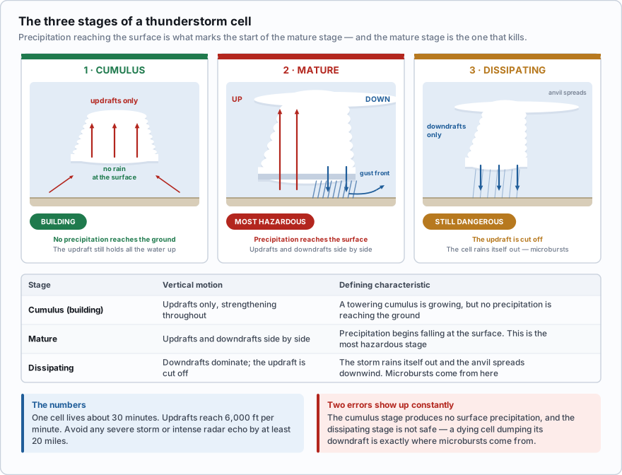
Every thunderstorm cell goes through the same three-act life. The exam wants the defining characteristic of each act, and it wants you to know which one will kill you.
| Stage | Vertical motion | Defining characteristic |
|---|---|---|
| Cumulus (building) | Updrafts only, strengthening throughout | A towering cumulus is growing, but no precipitation is reaching the ground |
| Mature | Updrafts and downdrafts side by side | Precipitation begins falling at the surface. This is the most hazardous stage |
| Dissipating | Downdrafts dominate; the updraft is cut off | The storm rains itself out and the anvil spreads downwind |
The mechanism is worth understanding as well as memorizing. In the cumulus stage the updraft is strong enough to hold all the water it has condensed, so nothing falls out. As the cell grows, the water load becomes too heavy, and falling precipitation drags cold air down with it. That descending column is the downdraft. Once it reaches the ground, the storm has both an updraft feeding it and a downdraft cutting it apart — the mature stage. Eventually the downdraft spreads out across the whole base, chokes off the inflow, and the storm starves. That is dissipation.
- An individual cell lives about 30 minutes. A storm complex lives for hours because new cells keep forming.
- Updrafts in the mature stage can reach 6,000 feet per minute.
- Avoid any thunderstorm identified as severe, or giving an intense radar echo, by at least 20 miles.
- Severe thunderstorm criteria: surface winds of 50 knots or more, hail 3/4 inch or larger, or a tornado.
- Never fly under a thunderstorm, and never fly under its anvil.
Two errors show up constantly. First, the cumulus stage does not produce precipitation at the surface — precipitation at the surface is what defines the mature stage. Second, the dissipating stage is not safe. It is downdraft-dominated, and a dying cell dumping its downdraft is exactly where microbursts come from.
Which thunderstorm stage is characterized by the presence of both updrafts and downdrafts, with precipitation reaching the surface?
- Cumulus
- Mature
- Dissipating
Answer: B. The mature stage begins when precipitation reaches the ground, and it is the only stage with strong updrafts and downdrafts operating together. It is the most hazardous stage of the cell.
Storm types and the gust front
A single-cell (air mass) thunderstorm is one cell, thirty minutes, usually a local afternoon event. A multicell cluster is several cells at different stages sharing one outflow, which is why it outlives any single cell. A supercell has one persistent rotating updraft, lasts for hours, and produces most significant hail and nearly all strong tornadoes. A squall line, from the previous lesson, can run 50 to 300 miles ahead of a fast-moving cold front.
Whatever the type, the hazard that catches drone pilots is the gust front. Cold downdraft air spreading out from a storm base behaves like water poured on a table, and its leading edge can arrive 15 miles or more ahead of the storm itself. The signs are a sudden wind shift, a sharp temperature drop, a wall of dust or a shelf cloud — with clear sky overhead. Your aircraft is airborne in what looks like fine weather when the wind goes from 6 knots to 35 in under a minute.
Microbursts
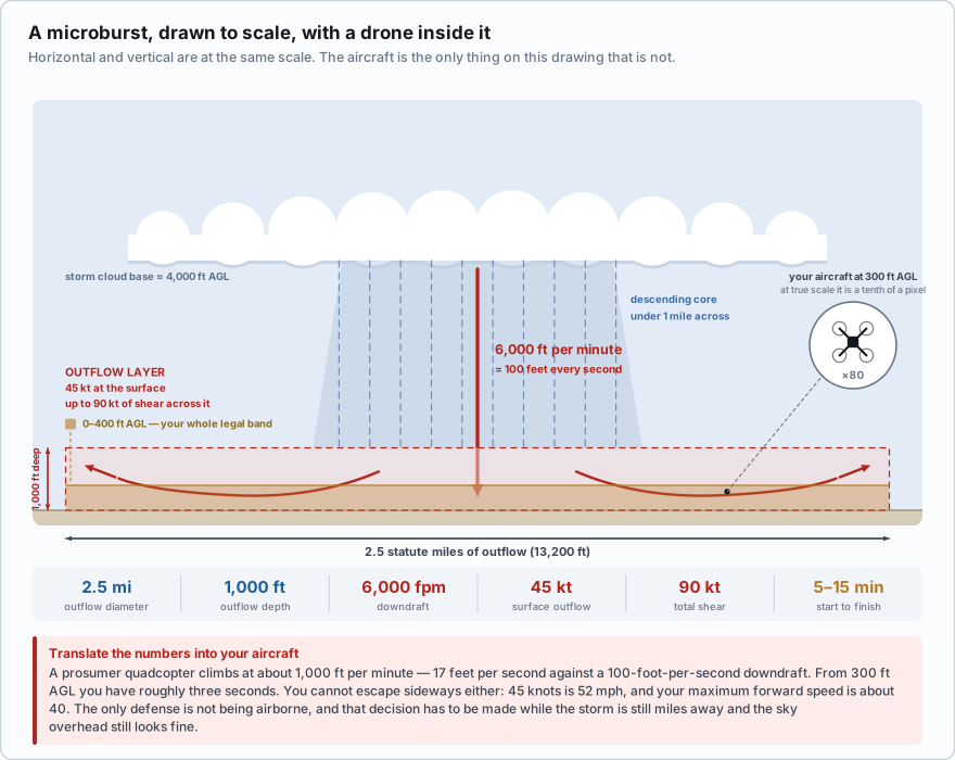
A microburst is a small, intense, concentrated downdraft. It is the most dangerous single wind event in aviation and it has brought down airliners. Here is the anatomy, with the numbers the FAA publishes.
- The descending column is typically less than 1 mile in diameter as it leaves the cloud base
- When it hits the ground it spreads outward into an outflow roughly 2.5 miles in diameter and about 1,000 feet deep
- Downdrafts can be as strong as 6,000 feet per minute
- Horizontal winds near the surface can reach 45 knots, producing up to a 90-knot headwind-to-tailwind shear for anything flying through
- A microburst intensifies for about 5 minutes after it strikes the ground and seldom lasts longer than 15 minutes total, with peak winds lasting only 2 to 4 minutes
- Microbursts can occur in dry conditions with no rain reaching the ground — virga, rain evaporating below the cloud base, is the visual warning
Now translate those numbers into your aircraft. Six thousand feet per minute is 100 feet per second straight down. A typical prosumer quadcopter climbs at about 1,000 feet per minute in its best mode — call it 17 feet per second. The downdraft beats your maximum climb rate by a factor of six. From 300 feet AGL, you have roughly three seconds.
You cannot run away sideways either. Forty-five knots is 52 miles per hour. Folding consumer quadcopters are typically rated to resist somewhere around 20 to 24 knots of wind, and their maximum forward speed in sport mode is in the neighborhood of 40 miles per hour — into a 52 mph outflow, your groundspeed is negative. The aircraft goes where the air goes.
This is the point of the lesson. A microburst is not a windy patch you fly through carefully. For a three-pound aircraft it is a total loss, and it begins and ends in less time than it takes to walk back to the truck. The only defense is not being airborne, and that decision has to be made while the storm is still miles away and the sky overhead still looks fine.
You are flying a roof survey at 250 ft AGL. A thunderstorm cell is about 8 miles west and the sky over your site is clear. The wind, which has been 5 knots from the south all morning, suddenly shifts to the west at 25 knots and the temperature drops noticeably. What is the correct action?
- Continue the survey, since the storm is 8 miles away and the sky overhead is clear
- Land immediately and secure the aircraft
- Climb to 400 ft AGL to get above the turbulent layer
Answer: B. A sudden wind shift with a temperature drop and clear sky overhead is the signature of a gust front, which can precede a storm by 15 miles or more. Conditions will deteriorate rapidly, and climbing puts you deeper into the shear. Land now.
Lightning
A thunderstorm separates electrical charge as ice and water particles collide inside it, then discharges within the cloud, between clouds, or to the ground. The stroke heats the air in its channel violently, and that is what produces thunder.
You do not need a direct strike for lightning to end your flight. The electromagnetic pulse from a nearby discharge can corrupt your control link, upset the aircraft's magnetometer so the compass reads wrong, and interfere with GNSS reception. Flying through precipitation also builds static charge on the airframe — precipitation static — which shows up as radio noise and, in extreme cases, corona discharge on the propeller tips.
The bigger risk, honestly, is you. The remote pilot and visual observer stand outdoors in the open holding a controller with a metal antenna, often on a roof or in a field. Lightning can strike more than 10 miles from the parent cell out of apparently clear sky — the bolt from the blue, which travels out through the anvil.
- If you hear thunder within 30 seconds of seeing the flash, the strike was within about 6 miles. Get the crew into a hard-topped vehicle or a substantial building.
- Wait 30 minutes after the last thunder before going back outside.
- Sound travels about 1 mile every 5 seconds — that is where the 30-second figure comes from.
Hail
Hail forms when a strong updraft carries droplets above the freezing level, where they freeze, gather more supercooled water, are lifted again, and grow in layers until the updraft can no longer hold them. Stronger updraft, bigger hail. A stone of 3/4 inch or larger is one of the criteria that makes a thunderstorm officially severe.
The operationally important fact is that hail does not stay under the storm. It can be carried out along the anvil and fall in clear air up to 20 miles from the parent cell. For a small drone hail is not a control problem but a structural one: a 3/4-inch stone at highway speed shatters propellers and destroys a gimbal, and the shaft arrives faster than you can descend and land.
Tornadoes
A tornado is a violently rotating column of air extending from the base of a cumulonimbus down to the ground. Winds in the core can exceed 200 knots, with an extreme pressure drop. When the visible condensation funnel has not reached the surface it is called a funnel cloud; over water the same phenomenon is a waterspout.
Tornadoes are most associated with supercells, but they also form along squall lines and in hurricane rainbands. The visual precursors — a lowered, rotating wall cloud beneath a rain-free storm base, or a dust whirl on the ground under it — are the point at which the aircraft should already be in its case.
Do not treat a tornado watch or warning as a distant abstraction because your specific county is clear. The parent storm carries all the other hazards with it: severe turbulence, microbursts, and hail thrown 20 miles downwind. The tornado is the headline, not the boundary of the danger.
Putting it into a decision
For drone work the rule is short. If convective activity is observed or forecast within about 20 miles and is moving toward you, do not launch. If you are airborne, land before the outflow arrives, not when it arrives. Check the Convective SIGMET and the radar mosaic twice: at the office, and again before you open the case. Lesson 3.9 shows you where to find both.
Which set of conditions is required for a thunderstorm to form?
- High pressure, cold air, and clear skies
- Sufficient water vapor, an unstable lapse rate, and a lifting action
- A temperature inversion, high humidity, and light surface winds
Answer: B. Moisture, instability, and a lifting trigger are the three necessary ingredients. An inversion is the most stable condition in the atmosphere and actively suppresses thunderstorms rather than causing them.
- Thunderstorms require three ingredients: sufficient water vapor, an unstable lapse rate, and a lifting action
- Cumulus stage has updrafts only and no precipitation reaching the ground; the mature stage adds downdrafts and surface precipitation and is the most hazardous; the dissipating stage is downdraft-dominated
- An individual cell lives about 30 minutes, and severe storms or intense radar echoes must be avoided by at least 20 miles
- A microburst outflow is about 2.5 miles across and 1,000 ft deep, with downdrafts to 6,000 fpm and 45-knot surface winds producing up to 90 knots of shear, all inside 5 to 15 minutes
- A gust front can arrive 15 miles or more ahead of a storm under clear sky — a sudden wind shift with a temperature drop means land now
- Hail can fall in clear air up to 20 miles from the storm, and lightning can strike more than 10 miles from the parent cell
- Use the 30/30 rule for the ground crew: shelter if thunder follows the flash within 30 seconds, and wait 30 minutes after the last thunder