Track your progress, take practice exams, and study the flashcards in the app.
3.3 Air Masses and Fronts
- Explain how an air mass takes on the temperature and moisture of its source region
- Predict how an air mass changes when it moves over a warmer or colder surface
- Identify the weather before, during, and after a cold, warm, stationary, and occluded front
- State the one thing that always happens to the wind at a frontal passage
The last lesson gave you the machinery: stable air behaves one way, unstable air another. This lesson tells you where those two kinds of air come from, what happens where they meet, and how to read a forecast map so you know which one is sitting over your job site tomorrow.
Air masses take after their birthplace
An air mass is a very large body of air — often bigger than several states — with fairly uniform temperature and moisture throughout. It gets that uniformity by sitting still. Park a body of air over central Canada in January for a few days with light winds and it becomes cold and dry, because that is what central Canada in January is. Park it over the Gulf of Mexico in July and it becomes warm and wet. The area it sits over is called the source region.
Air masses are named for two properties of that source region: how moist it is, and how cold it is.
| Code | Name | Source region | Character |
|---|---|---|---|
| cP | Continental polar | Interior Canada and Alaska | Cold and dry |
| cA | Continental arctic | The Arctic basin | Very cold and very dry |
| mP | Maritime polar | North Pacific and North Atlantic | Cool and moist |
| mT | Maritime tropical | Gulf of Mexico, Caribbean, subtropical oceans | Warm and moist |
| cT | Continental tropical | Northern Mexico and the desert Southwest | Hot and dry |
You do not need to memorize the codes for the exam. You do need the idea behind them, because the next part is tested directly.
What happens when an air mass moves
An air mass does not keep its source-region character forever. As soon as it starts traveling it is modified from below by whatever surface it crosses, and that modification changes its stability.
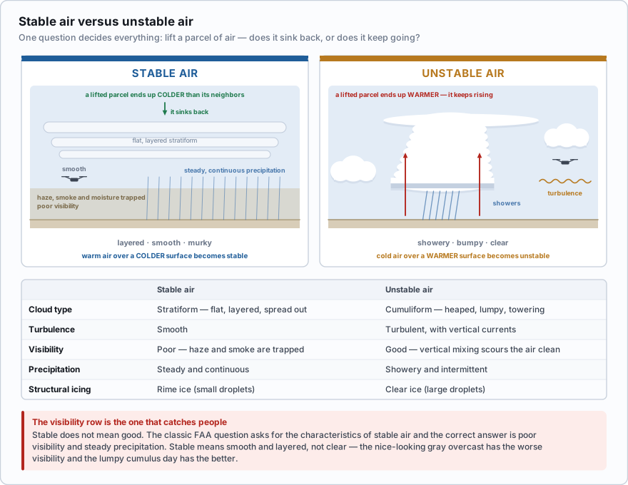
- A warm air mass moving over a colder surface is cooled from below. Cooling the bottom of a layer makes it more stable. Expect stratus, fog, drizzle, poor visibility, and smooth air.
- A cold air mass moving over a warmer surface is heated from below. Heating the bottom of a layer makes it less stable. Expect cumulus, showers, turbulence, and good visibility.
- The rule in one line: warm over cold is stable, cold over warm is unstable.
Maritime tropical air comes north off the Gulf in March and slides over ground that is still cold from winter. The bottom of the layer chills below its dew point. You get a gray stratus deck at 600 ft, four miles of visibility in mist, dead calm air, and a client asking why you are not flying. That same maritime tropical air arrives in August over ground that is 35 °C. The bottom of the layer is heated hard, becomes buoyant, and starts convecting. By two in the afternoon you have towering cumulus, forty-mile visibility between the clouds, and a thunderstorm building over the next county. Same air. Different surface. Opposite weather.
A maritime polar air mass moves inland over ground that is considerably warmer than the ocean it came from. What should you expect?
- Increasing stability, with stratus cloud and fog
- Increasing instability, with cumulus cloud and showers
- No change, because the air mass keeps the character of its source region
Answer: B. Heating an air mass from below makes it less stable. The warm surface heats the lowest layer, it becomes buoyant, and it convects — producing cumuliform cloud, showery precipitation, turbulence and good visibility.
Fronts: where two air masses meet
A front is the boundary zone between two air masses of different character. Air masses do not blend easily, so the boundary stays reasonably sharp and the weather along it is concentrated. Fronts are named for the air mass that is winning.
Whatever the type, a frontal passage always shows up as a set of discontinuities — things that change abruptly as the boundary goes past your position.
- Temperature — the most obvious change, and often a large one in a short time
- Dew point — the moisture content changes, usually along with the temperature
- Wind direction — always shifts, and always in the same rotational sense (below)
- Pressure — falls steadily as the front approaches, reaches its lowest value at the front, then rises after it passes
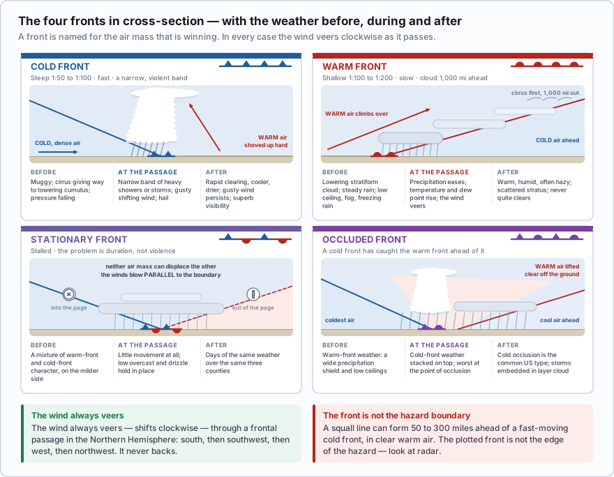
- In the Northern Hemisphere, the wind always veers at a frontal passage — it shifts clockwise around the compass.
- Example: south, then southwest, then west, then northwest.
- It never backs (shifts counterclockwise) through a frontal passage. This is a direct exam item and a genuinely useful field observation.
- Practically: if your windsock swings clockwise and holds, the front is through. If it swings back and forth without settling, it is not.
The cold front
Cold air is dense, so it stays on the ground and shoves under the warm air ahead of it like a wedge. Friction with the ground slows the bottom of the wedge, which makes the leading edge steep — a slope of roughly 1 in 50 to 1 in 100. Steep lifting over a short distance means violent, concentrated weather in a narrow band.
- Ahead of it: high humidity, cirrus giving way to towering cumulus, falling pressure, warm and often muggy
- At the passage: a narrow band of heavy showers or thunderstorms, sharp temperature drop, gusty and shifting winds, severe turbulence, sometimes hail
- Behind it: rapid clearing, cooler and drier, gusty winds that persist for hours, scattered cumulus, and often the best visibility you will see all month
A fast-moving cold front can trigger a squall line: a solid, non-frontal band of active thunderstorms that forms 50 to 300 miles ahead of the front in the warm moist air. Squall lines often contain the most intense weather hazards in aviation — severe turbulence, hail, and tornadoes — and they can stretch for hundreds of miles with no usable gap. They frequently develop in the late afternoon and early evening.
The plotted position of a cold front on a map is not the edge of the hazard. A squall line running 50 to 300 miles ahead of it can put severe thunderstorms over your site half a day before the front itself arrives, under a sky that looked fine at breakfast. Look at radar, not only at the frontal symbol.
The warm front
Warm air is less dense, so when it advances it has to climb up and over the cold air it is displacing. It cannot push the cold air out of the way. The result is a very shallow slope — roughly 1 in 100 to 1 in 200 — and a warm front is slow, typically moving at 10 to 25 knots, about half the speed of a cold front.
That shallow slope spreads the weather out over an enormous distance. The first sign of a warm front can appear a thousand miles ahead of the surface position, in a sequence you can actually watch develop over a day or two: cirrus, then cirrostratus (the halo around the sun), then altostratus, then nimbostratus with steady rain, then low stratus and fog at the surface.
- Ahead of it: lowering, thickening stratiform cloud, steady and continuous precipitation, deteriorating visibility, fog, low ceilings, and in winter the freezing rain and ice pellets that come from rain falling out of warm air aloft into subfreezing air near the ground
- At the passage: precipitation eases, temperature and dew point rise, wind veers
- Behind it: warm, humid, often hazy with poor visibility, scattered stratus, and a general feeling that the weather never quite cleared
For drone work, warm fronts are the ceiling-and-visibility problem and cold fronts are the wind-and-convection problem. A warm front will not throw your aircraft around. It will keep you on the ground for two days with an 800-foot overcast.
Stationary and occluded fronts
A stationary front is a boundary where neither air mass is strong enough to displace the other. The winds on each side blow roughly parallel to the front instead of into it. The weather is a mixture of warm-front and cold-front character, generally on the milder side — but the real problem is duration. A stationary front can sit over the same three counties for several days, holding a low overcast and drizzle in place the whole time.
An occluded front forms when a faster cold front catches the slower warm front ahead of it and lifts all of the warm air completely off the ground. Two versions exist:
- Cold occlusion — the air behind the front is colder than the air ahead of it, so it undercuts everything. This is the more common type in the United States.
- Warm occlusion — the air behind the front is milder than the cold air ahead of it, so it rides up over that air instead.
Either way you get warm-front weather ahead of the boundary and cold-front weather at and behind it, stacked on top of each other. The precipitation shield is wide, the ceilings are low, and the most severe conditions — including embedded thunderstorms you cannot see because they are buried inside layer cloud — sit near the point of occlusion, where the cold front, warm front, and occluded front all meet.
You are watching a front approach that has produced two days of gradually lowering stratiform cloud, steady light rain, and visibility down to 3 miles in mist. What type of front is it most likely to be?
- A cold front
- A warm front
- A squall line
Answer: B. Warm fronts have a shallow slope, move slowly, and spread stratiform cloud and steady, continuous precipitation over hundreds of miles ahead of the surface position. Cold fronts produce a narrow band of showery, convective weather instead.
One more boundary worth knowing if you work the southern Plains: the dryline. It is not a temperature boundary but a moisture boundary, separating moist Gulf air from dry desert air, and it commonly runs north-south through west Texas and Oklahoma in spring. Drylines are prolific thunderstorm generators. They are not on the exam, but if you fly agricultural or energy work in that region you will meet them.
Do not assume the clear, brilliant day behind a cold front is an easy flying day. It usually has the best visibility of the week and some of the strongest, gustiest surface wind, because the pressure gradient behind a departing front is steep. Excellent visibility and unflyable wind arrive together.
- An air mass takes the temperature and moisture of the source region it forms over, and is modified from below as it moves
- Warm air over a colder surface becomes more stable (stratus, fog, poor visibility, smooth); cold air over a warmer surface becomes less stable (cumulus, showers, turbulence, good visibility)
- A frontal passage always brings changes in temperature, dew point, wind, and pressure, and pressure is at its lowest at the front itself
- The wind always veers — shifts clockwise — with a frontal passage in the Northern Hemisphere
- Cold fronts are steep and fast: a narrow band of showers, thunderstorms and turbulence, then rapid clearing with strong gusty wind behind
- Warm fronts are shallow and slow: an enormous lead of stratiform cloud, steady precipitation, low ceilings, fog, and possible freezing rain
- A squall line can form 50 to 300 miles ahead of a fast-moving cold front and is among the most hazardous weather in aviation