Track your progress, take practice exams, and study the flashcards in the app.
3.2 Stability, Temperature and Moisture
- Distinguish the standard, dry adiabatic, and moist adiabatic lapse rates and use them to judge stability
- Predict cloud type, turbulence, visibility, and precipitation type from the stability of an air mass
- Use the temperature and dew point spread to anticipate cloud bases and fog
- Describe a temperature inversion and the two distinct hazards it creates
Atmospheric stability is the most productive idea in this module. Get it, and one line of a METAR tells you what the sky will do to your aircraft. The exam tests it repeatedly, usually by describing the air and asking what weather comes with it.
Stability answers one question: if you push a parcel of air upward, does it keep going, or does it sink back down? Air that sinks back is stable. Air that keeps rising on its own is unstable. That is all. Everything else follows.
Why lifted air cools
Take a bubble of air and lift it. Pressure decreases with height, so the bubble expands. Expanding takes energy, and the energy comes out of the bubble's own heat. It cools without giving any heat away to its surroundings — a process called adiabatic cooling. Push the bubble back down and it compresses and warms by exactly the same amount.
How fast it cools depends on whether it is carrying its water as invisible vapor or has started condensing it into cloud.
- Standard (average) lapse rate: 2 °C per 1,000 ft. How the real atmosphere cools with height on an average day. A statistic.
- Dry adiabatic lapse rate: 3 °C per 1,000 ft (5.4 °F). How an unsaturated parcel cools when lifted. A fixed physical value.
- Moist (saturated) adiabatic lapse rate: about 1.1 to 2.8 °C per 1,000 ft. How a saturated parcel cools when lifted. It is slower because condensation releases latent heat back into the parcel, partly offsetting the cooling. The exact value depends on temperature and moisture content — that is why it is a range, not a number.
- Three different rates, three different meanings. Do not average them, and do not swap them.
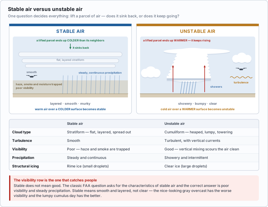
Now put a parcel into the real atmosphere and compare. If the surrounding air cools with height faster than the parcel does, the lifted parcel finds itself warmer than its neighbors, so it is buoyant and keeps climbing. That is unstable. If the surrounding air cools with height more slowly than the parcel does — or warms with height — the lifted parcel ends up colder and heavier than its neighbors and sinks back. That is stable.
What each kind of air feels like
This table is worth memorizing as a block. FAA questions describe one column and ask you to identify the other.
| Stable air | Unstable air | |
|---|---|---|
| Cloud type | Stratiform — flat, layered, spread out | Cumuliform — heaped, lumpy, towering |
| Turbulence | Smooth | Turbulent, with vertical currents |
| Visibility | Poor — haze and smoke are trapped | Good — vertical mixing scours the air clean |
| Precipitation | Steady and continuous | Showery and intermittent |
| Structural icing | Rime ice | Clear ice |
The visibility row is the one that catches people. It feels backwards: the nice-looking day with a smooth gray overcast has the worse visibility, and the lumpy, bumpy, cumulus-dotted day has the better visibility. The reason is mixing. Stable air does not mix vertically, so everything the ground puts into it — dust, exhaust, agricultural spray, smoke — stays in a shallow layer near the surface and piles up. Unstable air stirs constantly and dilutes all of it.
Stable does not mean good. A classic FAA question asks for the characteristics of stable air, and the correct answer is poor visibility and steady precipitation. Students who read stable as 'nice weather' pick the good-visibility option and lose the point. Stable means smooth and layered, not clear.
What are the characteristics of a moist, unstable air mass?
- Turbulence and showery precipitation
- Poor visibility and smooth air
- Haze and low stratus cloud
Answer: A. Unstable air rises on its own, which builds cumuliform cloud, produces turbulence, and delivers precipitation in showers rather than steadily. Poor visibility, smooth air, haze and stratus all belong to stable air.
What lifts air in the first place
Unstable air only produces weather if something starts it moving upward. There are four triggers, and you will see all of them again in the fronts and thunderstorms lessons.
- Convective lifting — the sun heats the surface, the surface heats the air touching it, and warm bubbles break loose and rise. Strongest over dark, dry surfaces in the middle of the afternoon.
- Orographic lifting — wind runs into rising terrain and has to go over it. Ridge lines, escarpments, even a long line of hills.
- Frontal lifting — one air mass wedges under or rides over another. Lesson 3.3.
- Convergence — surface winds flowing together from different directions force air upward, the way they do around a low or along a sea-breeze boundary.
Moisture: relative humidity and dew point
Warm air can hold more water vapor than cold air. Relative humidity is how full the air is compared with the most it could hold at its current temperature. It is a percentage, and it changes when the temperature changes even if no water is added or removed.
Dew point is more useful. It is the temperature the air would have to be cooled to, at constant pressure, before its water vapor starts condensing. Unlike relative humidity, the dew point is a direct measure of how much water is actually in the air. Cool the air to its dew point and you get visible moisture — cloud, fog, or dew on the grass.
The gap between the two is called the temperature/dew point spread, and it is the fastest read in all of aviation weather. A wide spread means dry air and a high cloud base. A narrow spread means the air is close to saturation. A spread that is closing over successive hourly reports is the classic warning that fog or a low ceiling is coming, and it is the number you should be watching on an evening job.
- Water vapor — there has to be moisture in the air to condense
- Condensation nuclei — microscopic particles (dust, salt, pollution, smoke) for the vapor to condense onto
- Cooling to the dew point — the temperature has to reach the point of saturation
- All three. Remove any one and you get no cloud and no fog.
There is also a handy relationship between the spread and the height of the cloud base. Lifted unsaturated air cools at 3 °C per 1,000 ft while its dew point falls at about 0.5 °C per 1,000 ft, so temperature and dew point converge at roughly 2.5 °C per 1,000 ft (about 4.4 °F per 1,000 ft).
You arrive at a farm to fly a crop survey. The nearest ASOS reports temperature 30 °C, dew point 15 °C. Spread = 30 − 15 = 15 °C Cloud base ≈ 15 ÷ 2.5 = 6, so about 6,000 ft AGL Plenty of room. Now check the same field at 7 p.m.: temperature 18 °C, dew point 16 °C. Spread = 2 °C Cloud base ≈ 2 ÷ 2.5 = 0.8, so about 800 ft AGL An 800-foot cloud base caps your legal altitude at 300 ft AGL, because you must stay 500 ft below the cloud. And a spread that small with the temperature still falling means fog is a live possibility within the hour.
The temperature is 20 °C and the dew point is 17 °C, and over the last three hourly reports the spread has gone from 8 °C to 5 °C to 3 °C. What should you expect?
- Rising cloud bases and improving visibility
- Cloud bases lowering, with fog or low stratus becoming likely
- No change, because the dew point is not the temperature yet
Answer: B. A closing spread means the air is approaching saturation. Cloud bases come down as the spread narrows, and if the temperature reaches the dew point at the surface you get fog. A closing spread is a warning, not a reassurance.
Temperature inversions
Normally temperature falls with height. An inversion is a layer where it does the opposite — temperature increases as you climb through it. An inversion is the most stable condition the atmosphere produces, because warm light air sitting on top of cold dense air has no reason to overturn.
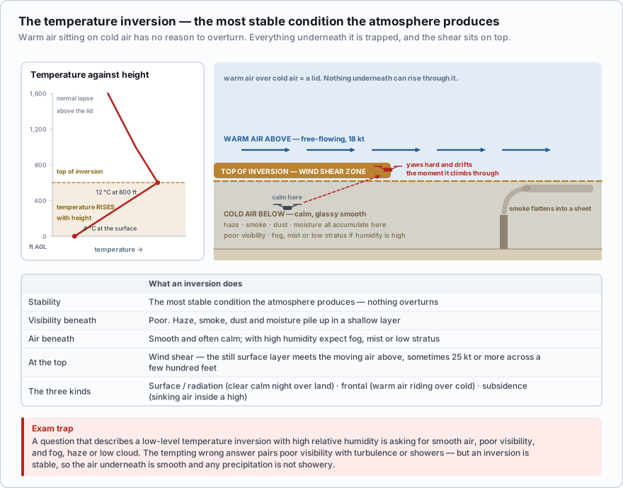
The most common kind for a drone pilot is the surface or radiation inversion. On a clear, calm night the ground radiates its heat away to space and cools quickly, and it chills the shallow layer of air in contact with it. By dawn you have cold air at the surface and warmer air a few hundred feet up. Valleys are worse than open ground because the cold air drains downhill and pools.
Two other kinds exist: a frontal inversion, where warm air rides up over a wedge of cold air at a warm front, and a subsidence inversion, where sinking air inside a high-pressure system warms as it descends and caps the layer beneath it. All three trap whatever is underneath.
- An inversion is the most stable condition in the atmosphere
- It traps haze, smoke, dust and moisture beneath it, so visibility underneath is poor
- With high relative humidity underneath, expect fog, haze, or low stratus and smooth air
- There is wind shear at the top of the inversion, where the still surface layer meets the moving air above — sometimes a low-level jet with 25 knots or more of change across a few hundred feet
A 6:45 a.m. real estate shoot in a river valley in October. The ASOS three miles away reports calm wind, 4 SM in mist, temperature 8 °C, dew point 8 °C. On the ground it is glassy. You launch, climb, and at about 250 ft AGL the aircraft yaws hard and starts drifting downriver, and the app throws a high-wind warning. You flew through the top of a radiation inversion. The surface layer was decoupled and calm; the air above it was moving at 18 knots. The reported wind was accurate — for the ten meters above the anemometer. Nothing about it described the shear layer two hundred feet up.
A question describes a low-level temperature inversion with high relative humidity and asks what to expect. The answer is smooth air, poor visibility, and fog, haze, or low clouds. The tempting wrong answer pairs poor visibility with turbulence or showers. Inversions are stable — the air underneath is smooth, and the precipitation, if any, is not showery.
The same inversion that ruins your morning visibility also carries sound and radio energy further than usual, and it is why an early-morning launch can hold a control link out to a distance you would not get at 2 p.m. It is also why smoke from a controlled burn or a neighbor's stove sits in a flat sheet at exactly the altitude you wanted to fly.
- Stability is whether a lifted parcel keeps rising (unstable) or sinks back (stable); compare the parcel's adiabatic cooling rate with the surrounding air's lapse rate
- Three lapse rates: standard 2 °C per 1,000 ft, dry adiabatic 3 °C per 1,000 ft, moist adiabatic about 1.1 to 2.8 °C per 1,000 ft
- Stable air gives stratiform cloud, smooth flight, poor visibility, steady precipitation and rime ice; unstable air gives cumuliform cloud, turbulence, good visibility, showers and clear ice
- Cloud and fog require all three of water vapor, condensation nuclei, and cooling to the dew point
- Temperature and dew point converge at about 2.5 °C per 1,000 ft, so the spread divided by 2.5 estimates the cloud base in thousands of feet
- A temperature inversion is the most stable condition in the atmosphere: it traps haze and moisture underneath, gives smooth air and poor visibility, and produces wind shear at its top