Track your progress, take practice exams, and study the flashcards in the app.
3.1 The Atmosphere and the Standard Day
- Describe how the atmosphere is layered and identify the layer where all your flying happens
- State the standard-day values for pressure, temperature, and lapse rate from memory
- Name the five kinds of altitude and compute pressure altitude from an altimeter setting
Weather is about 11 to 16 percent of the exam, which works out to roughly eight questions. That makes it a smaller area than Regulations or Airspace. But weather is the part of this course most likely to matter on a Tuesday afternoon with a client waiting. A regulation you get wrong usually costs you paperwork. Weather you get wrong costs you the aircraft, and sometimes more than that.
This module builds from the ground up. Before you can read a METAR or judge whether that line of cloud on the horizon is a problem, you need a working picture of what the air is actually doing. That starts here, with the air itself.
Air is a fluid, and it has weight
Think of the atmosphere as an ocean. You live at the bottom of it. It flows, it piles up in some places and thins out in others, and it presses down on everything underneath it. At sea level the column of air above one square inch of ground weighs about 14.7 pounds. That is atmospheric pressure, and almost everything in this module traces back to it.
By volume, dry air is about 78 percent nitrogen and 21 percent oxygen, with the last 1 percent made up of argon, carbon dioxide, and traces of other gases. Water vapor is not in that list because it varies: anywhere from nearly zero over a desert to about 5 percent over a warm ocean. That variable ingredient is the source of essentially all weather. Hold onto it — it comes back in every lesson from here on.
The layers, and the one you fly in
The atmosphere is layered by how temperature behaves with height. You only need the bottom two.
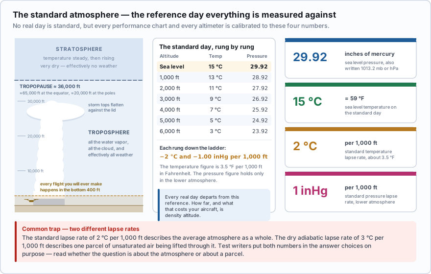
- Troposphere — the surface up to an average of about 36,000 ft. It is deeper over the equator (near 65,000 ft) and shallower over the poles (near 20,000 ft), and it sags in winter. Temperature decreases with height. Nearly all of the water vapor, nearly all of the cloud, and effectively all of the weather live here. Your drone never leaves it.
- Tropopause — the boundary at the top of the troposphere, where the temperature stops falling. It acts like a lid. Thunderstorm tops flatten out against it into the classic anvil, and the jet stream runs along it.
- Stratosphere — above the tropopause, temperature holds steady and then starts to increase. Very dry, very stable, almost no weather.
The standard day
No real day is standard. But engineers have to publish performance figures against something, and altimeters have to be calibrated against something, so aviation agreed on a fictional set of conditions called the International Standard Atmosphere. Every performance chart you will ever read, and every altimeter in every aircraft, is built on it.
- Sea level pressure: 29.92 inches of mercury (also written 1013.2 millibars or hectopascals)
- Sea level temperature: 15 °C, which is 59 °F
- Standard temperature lapse rate: 2 °C per 1,000 ft (about 3.5 °F per 1,000 ft)
- Standard pressure lapse rate: about 1 inch of mercury per 1,000 ft in the lower atmosphere
- These four numbers appear on the exam directly and are used inside half a dozen other calculations. Memorize them.
The lapse rate is worth a second look. It says that on a standard day, if it is 15 °C at sea level, it is 13 °C at 1,000 ft, 11 °C at 2,000 ft, and so on. That is the average rate at which the real atmosphere cools with height — an observed statistic, not a law of physics. You will meet two other lapse rates in the next lesson that describe something different: what happens to a specific parcel of air when you lift it. Keeping those three straight is the single most common stumbling point in this module.
Do not confuse the standard lapse rate (2 °C per 1,000 ft) with the dry adiabatic lapse rate (3 °C per 1,000 ft). The standard rate describes the atmosphere as a whole on an average day. The dry adiabatic rate describes one parcel of unsaturated air being lifted. Test writers put both numbers in the answer choices on purpose.
On a standard day, what is the temperature at 5,000 feet above sea level?
- 5 °C
- 10 °C
- 15 °C
Answer: A. Start at the standard sea level temperature of 15 °C and subtract 2 °C for every 1,000 ft: 15 − (5 × 2) = 5 °C.
Highs, lows, and why air moves
The sun does not heat the Earth evenly. The equator gets more energy than the poles, land heats faster than water, and a parking lot heats faster than the field next to it. Uneven heating produces uneven pressure, and air moves from where there is more of it to where there is less. That movement is wind.
It does not move in a straight line, though. The Earth is rotating underneath it, which deflects moving air to the right in the Northern Hemisphere. That deflection is called the Coriolis effect, and it turns a simple high-to-low flow into a rotating system.
- Around a high, air circulates clockwise and spirals outward. Air sinks from above to replace it. Sinking air compresses and warms, which dries it out — so highs generally mean settled, clear weather. They also act like a lid, trapping haze, smoke, and pollutants near the ground.
- Around a low, air circulates counterclockwise and spirals inward. All that converging air has nowhere to go but up. Rising air expands and cools, and cooling air condenses — so lows generally mean cloud, precipitation, and wind.
- A useful memory hook: highs are dry, lows are lousy.
There is an old altimetry saying: high to low, look out below. Fly from an area of high pressure into an area of low pressure without resetting your altimeter and it will over-read, meaning you are lower than it says. The same is true for temperature: flying from warm air into cold air makes the altimeter over-read. Most drones use a barometric sensor zeroed at takeoff, so this shows up as slow altitude drift over a long day on site. It is not on the exam, but it is why your reported altitude and your actual height can quietly diverge over three hours of flying.
Five kinds of altitude
Aviation uses the word altitude in five distinct ways. The exam tests the difference, and two of them drive drone performance directly.
| Altitude | What it means | How you get it |
|---|---|---|
| Indicated | What the altimeter reads | Set the current local altimeter setting in the window |
| True | Actual height above mean sea level (MSL) | Indicated altitude when pressure and temperature are near standard |
| Absolute | Height above the ground directly below you (AGL) | True altitude minus the terrain elevation under the aircraft |
| Pressure | Height above the standard datum plane — the level where pressure would be 29.92 | Set 29.92 in the altimeter, or compute it |
| Density | Pressure altitude corrected for nonstandard temperature | Compute it — Lesson 3.7 |
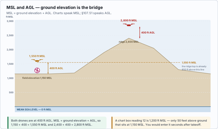
For drone work the distinction between MSL and AGL is constant and practical. Sectional charts publish airspace floors and ceilings in MSL. Section 107.51 caps you at 400 feet AGL. Your aircraft's app almost certainly shows you height above the takeoff point, which is neither of those things the moment the terrain under you changes. Launch from the bottom of a quarry, fly out over the rim, and the number on your screen says 380 while your actual height above the ground beneath you is 60.
Pressure altitude: the one calculation
Pressure altitude is the bridge between the real atmosphere and the standard one. You need it before you can find density altitude, and density altitude is what determines how well your aircraft performs. There is one formula, and it is easy.
- Pressure altitude = (29.92 − altimeter setting) × 1,000 + field elevation
- If the altimeter setting is below 29.92, pressure altitude is higher than field elevation
- If the altimeter setting is above 29.92, pressure altitude is lower than field elevation
- The altimeter setting comes from a METAR (the A-group, for example A2992) or from an AWOS or ASOS broadcast
You are photographing a construction site at 4,700 ft MSL. The nearest reporting station gives an altimeter setting of 29.55. Pressure altitude = (29.92 − 29.55) × 1,000 + 4,700 = (0.37 × 1,000) + 4,700 = 370 + 4,700 = 5,070 ft Lower pressure than standard, so the air behaves as though the site were 370 feet higher than it actually is.
A winter roof inspection at a field elevation of 1,200 ft MSL. Altimeter setting 30.42. Pressure altitude = (29.92 − 30.42) × 1,000 + 1,200 = (−0.50 × 1,000) + 1,200 = −500 + 1,200 = 700 ft Higher pressure than standard, so the air is denser than the site elevation alone would suggest. Your aircraft will feel noticeably stronger.
Field elevation is 2,000 feet MSL and the altimeter setting is 29.42. What is the pressure altitude?
- 1,500 ft
- 2,500 ft
- 2,000 ft
Answer: B. (29.92 − 29.42) = 0.50. Multiply by 1,000 to get 500, then add the field elevation: 500 + 2,000 = 2,500 ft. The setting is below 29.92, so pressure altitude comes out above field elevation.
That is the whole atmospheric foundation. Pressure, temperature, and the standard day are the reference frame. Everything from here — stability, fronts, fog, thunderstorms, density altitude — is a story about how the real atmosphere departs from that reference, and what it costs you when it does.
- Nearly all weather occurs in the troposphere, which averages about 36,000 ft deep and is where every drone flight takes place
- Standard atmosphere: 29.92 inHg and 15 °C (59 °F) at sea level, temperature falling about 2 °C per 1,000 ft and pressure about 1 inHg per 1,000 ft
- The standard lapse rate of 2 °C per 1,000 ft describes the average atmosphere; it is not the same as the 3 °C per 1,000 ft dry adiabatic rate for a lifted parcel
- Highs circulate clockwise and outward with sinking, drying air; lows circulate counterclockwise and inward with rising, condensing air
- MSL is height above sea level, AGL is height above the ground below you, and charts use MSL while Part 107 uses AGL
- Pressure altitude = (29.92 − altimeter setting) × 1,000 + field elevation