Track your progress, take practice exams, and study the flashcards in the app.
2.8 Other Airspace — MTRs, TRSAs, NSAs, Parachute Areas, Wildlife Refuges
- Read a military training route designator and state whether the route includes segments above 1,500 feet AGL
- Describe TRSAs, National Security Areas, parachute jump areas and published VFR routes and what each requires
- Distinguish the wildlife refuge altitude advisory from the National Park Service ground rule
This lesson collects the airspace that is neither a lettered class nor special use airspace. None of it requires an ATC authorization. All of it can hurt you, and the exam samples from it heavily because it is where careless study shows.
Military Training Routes
A military training route (MTR) is a corridor used by military aircraft to practice low-altitude, high-speed flight. Traffic on an MTR is typically faster than 250 knots and can be as low as a few hundred feet above the ground. A fighter at 450 knots covers a nautical mile in eight seconds. You will not see it in time to react.
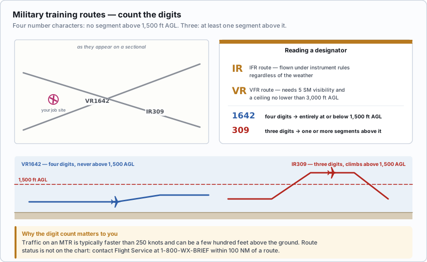
MTRs appear as thin gray lines with the route designator printed along the centerline. Two letters and a number tell you everything:
- IR — an IFR military training route. Flown under instrument flight rules regardless of weather.
- VR — a VFR military training route. Flown under visual rules, requiring at least 5 miles of flight visibility and a ceiling no lower than 3,000 feet AGL.
Now the digit count, which is the tested fact:
MTRs with no segment above 1,500 feet AGL must be identified by four number characters; e.g., IR1206, VR1207. MTRs that include one or more segments above 1,500 feet AGL must be identified by three number characters; e.g., IR206, VR207.
Four digits means the entire route stays at or below 1,500 feet AGL. Three digits means at least part of it goes above 1,500 feet AGL.
Count the digits after the letters, not the whole string. VR1667 has four digits, so that route is flown entirely at or below 1,500 feet AGL — squarely in the altitude band a drone occupies. IR206 has three, so somewhere along it the aircraft climb higher. Either way the route can and does contain traffic below 1,500 AGL, so an MTR crossing your job site deserves a phone call.
Contact Flight Service within 100 nautical miles of an MTR for current route activity and scheduled use times. Call 1-800-WX-BRIEF or ask during an online briefing. The route status is not on the chart, only the route itself.
A sectional shows a route labeled VR1667. What does the designator tell a remote pilot?
- It is an IFR route with segments above 1,500 feet AGL
- It is a VFR route flown entirely at or below 1,500 feet AGL
- It is a VFR route that operates only above 10,000 feet MSL
Answer: B. VR means the route is flown under visual flight rules, and four number characters mean no segment of the route is above 1,500 feet AGL. That places the traffic in the same low-altitude band a drone works in.
Terminal Radar Service Areas
A TRSA is a leftover from an older system. It surrounds certain airports where radar service is offered to VFR traffic, but the airspace was never converted to Class B or C. The primary airport inside a TRSA is Class D.
TRSAs are charted with a screened black outline with altitude segments labeled. Participation is voluntary even for manned VFR pilots, and a TRSA is not one of the airspace classes listed in §107.41. A TRSA requires no ATC authorization for a Part 107 flight. The Class D at its center does.
National Security Areas
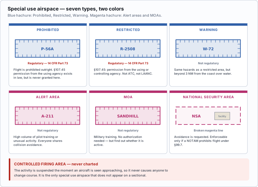
A National Security Area (NSA) is airspace over a ground facility that needs extra security and safety — a weapons plant, a naval facility, a laboratory. It is charted with a broken (dashed) magenta line and labeled with its altitude and a note.
Pilots are requested to voluntarily avoid flying through an NSA. It is a request, not a prohibition — unless the FAA issues a NOTAM temporarily prohibiting flight under 14 CFR §99.7. When that happens, the prohibition is enforceable, and you find out about it by checking NOTAMs, which is the only way you find out about anything temporary.
Note the depiction carefully: dashed magenta again, but around a *facility* and labeled NSA, not around an airport. Context separates it from a Class E surface area.
Parachute jump areas
Charted with a parachute symbol and often a frequency, these mark airports and sites with regular jump operations under 14 CFR Part 105. Jump altitudes are given in MSL. Jump aircraft broadcast their intentions on the CTAF, and canopies descend far faster than they look like they are descending.
Nothing prohibits a Part 107 flight near a charted jump area, but a parachutist under canopy is not going to see or avoid your aircraft. Monitor the CTAF, and pick a different day if jumping is in progress.
Wildlife refuges, parks and wilderness areas
Sectionals chart National Parks, National Monuments, National Wildlife Refuges, and Primitive and Wilderness Areas with a distinctive boundary and the area's name. Two separate rules apply, and they get conflated constantly.
- The airspace advisory. AIM 7-5-6 states that pilots are requested to maintain a minimum altitude of 2,000 feet above the surface of these areas. The word in the AIM is *requested*. It is an advisory aimed at protecting wildlife and visitors, not a regulation, and a Part 107 pilot capped at 400 feet AGL cannot comply with it anyway.
- The ground rule. The National Park Service separately prohibits launching, landing or operating unmanned aircraft from or on lands and waters it administers, under its closure authority in 36 CFR §1.5. That is enforceable, and it is about the ground, not the air. The FAA controls the airspace; the land manager controls the dirt.
The practical translation for a working drone pilot: you may not set up in a national park, but you may set up legally outside the boundary. The US Fish and Wildlife Service and the US Forest Service each have their own land-use rules, and the AIM also notes that landing an aircraft on NPS, FWS or Forest Service land requires that agency's authorization.
Which statement about the 2,000 foot altitude over a charted national wildlife refuge is correct?
- It is a regulatory minimum altitude enforceable against Part 107 operators
- It is an advisory in the AIM asking pilots to remain 2,000 feet above the surface
- It applies only to aircraft carrying passengers
Answer: B. AIM 7-5-6 says pilots are requested to maintain a minimum of 2,000 feet above the surface. It is advisory. What is enforceable is the National Park Service prohibition in 36 CFR 1.5 on launching, landing or operating from park land.
Airport advisory services and published VFR routes
Two smaller items round out the list. Local Airport Advisory (LAA) is a Flight Service product available in Alaska at certain non-towered airports with a Flight Service Station on the field, providing advisories within 10 statute miles. Remote Airport Information Service (RAIS) supports short-term special events and is advertised by NOTAM only.
Published VFR routes help manned pilots move around busy airspace. VFR flyways are suggested paths that avoid Class B. VFR corridors are defined tunnels through Class B that need no clearance. VFR transition routes are charted courses through Class B that do require ATC clearance. They appear mainly on Terminal Area Charts. A corridor does not create a Part 107 exception — if you are inside the lateral and vertical limits of Class B, §107.41 applies regardless.
- MTRs: four digits = no segment above 1,500 ft AGL. Three digits = one or more segments above 1,500 ft AGL.
- IR = IFR route flown regardless of weather. VR = VFR route.
- Contact Flight Service within 100 NM of an MTR for route activity.
- A TRSA is charted with a screened black outline, participation is voluntary, and it needs no Part 107 authorization. Its primary airport is Class D.
- A National Security Area is a broken magenta line; avoidance is requested unless a NOTAM prohibits flight under §99.7.
- AIM 7-5-6 *requests* 2,000 ft above wildlife refuges, parks and wilderness. 36 CFR §1.5 *prohibits* launching, landing or operating from National Park Service land.
There is no hot-air-balloon activity symbol on a sectional chart. If an answer option offers one, it is wrong. What charts do carry is a CAUTION box for a specific hazard — for example an unmarked balloon on a cable, with its top altitude given in MSL. Read those boxes; they are printed in plain English and they are exam material.
If your work regularly takes you near an MTR, ask Flight Service for the route's scheduling agency and call them directly. Squadrons publish their training windows internally and are usually happy to tell a civilian operator when the route is cold. That single phone call is worth more than any amount of chart study on a day you need to be at 300 feet under a low-level route.
- Military training route designators with four digits stay at or below 1,500 feet AGL; three digits include segments above it
- IR routes are flown under instrument rules regardless of weather; VR routes are flown visually
- Contact Flight Service within 100 NM of an MTR to learn whether the route is active
- TRSAs are voluntary, charted with a screened black outline, and require no Part 107 authorization
- National Security Areas are drawn with a broken magenta line and ask for voluntary avoidance unless a NOTAM prohibits flight
- AIM 7-5-6 requests 2,000 feet above parks and refuges; 36 CFR 1.5 prohibits operating from National Park Service land
- No hot-air-balloon activity symbol exists on sectional charts