Track your progress, take practice exams, and study the flashcards in the app.
2.7 Special Use Airspace
- Name the seven kinds of special use airspace and describe what happens inside each
- Identify prohibited, restricted, warning, alert areas and MOAs from their chart depiction
- State what §107.45 requires before operating in a prohibited or restricted area
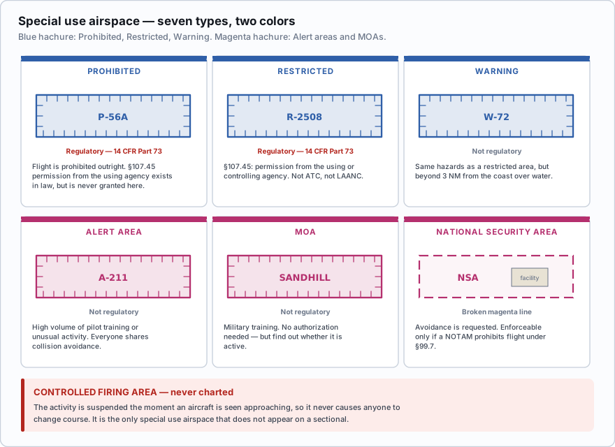
Special use airspace (SUA) is airspace set aside because something is happening inside it that other aircraft need to know about — live artillery, fighter training, a facility that must not be overflown. AIM 3-4 defines seven kinds. Two of them — Prohibited and Restricted — are regulatory, established in the Code of Federal Regulations and carrying the force of law. The other five (Warning, MOA, Alert, Controlled Firing Area and National Security Area) are nonregulatory.
The color rule for SUA
SUA boundaries are drawn as a hachured band — a line with short tick marks running along its inner edge, so the band appears to have teeth pointing into the area. The color splits the charted types into two groups, and it is a clean split worth memorizing:
- Blue hachure: Prohibited (P), Restricted (R) and Warning (W) areas. These are the ones where something dangerous or forbidden is going on.
- Magenta hachure: Alert Areas (A) and Military Operations Areas (MOA). These are the ones that say *be careful, look out*.
Prohibited areas
A prohibited area is airspace in which the flight of aircraft is prohibited, full stop. They protect places of national security or welfare significance — the White House, Camp David, Mount Vernon. They are numbered P-40, P-56A and so on, and they are established under 14 CFR Part 73.
§ 107.45 does provide one route in — *permission from the using or controlling agency, as appropriate* — and the same sentence covers restricted areas. But for a prohibited area that permission is realistically never granted for commercial drone work, and it is not something LAANC or an FAA authorization can get for you. Treat the practical answer as do not plan work inside one, while knowing the regulation says "unless you have permission", not "never".
Restricted areas
A restricted area contains hazards to aircraft that are invisible from outside — artillery firing, aerial gunnery, guided missiles. Flight is not prohibited outright, but it is subject to restrictions. They are numbered like R-2508 and are also Part 73 regulatory airspace.
No person may operate a small unmanned aircraft in prohibited or restricted areas unless that person has permission from the using or controlling agency, as appropriate.
Read the source of the permission carefully, because it is a common trick. Permission for a restricted area comes from the using or controlling agency — normally the military unit that owns it — not from air traffic control and not through LAANC. LAANC handles §107.41 airspace authorization. It does not handle §107.45 permission. Those are two separate approvals, and a site can need both.
Restricted areas are often part time. Many are active only on weekdays during published hours, and outside those hours the airspace is available. The chart's SUA tabulation panel gives the times of use, the altitudes and the controlling agency for every area on that chart.
Warning areas
A warning area contains the same sort of hazardous activity as a restricted area, but it lies beyond 3 nautical miles from the coast of the United States, over domestic or international waters. Because the US cannot legally prohibit flight in international airspace, the FAA warns rather than restricts. They are numbered like W-72 and drawn with the same blue hachure.
Military Operations Areas
An MOA separates military training — air combat maneuvering, formation work, aerobatics — from IFR traffic. MOAs carry names, not numbers: the Devils Lake West MOA, the Snowbird MOA. They are drawn with magenta hachure.
A Part 107 operation is not prohibited inside an MOA, and no authorization is required for the MOA itself. What is required is judgment. Military aircraft inside an active MOA maneuver aggressively and can be very fast and very low. Before working under or inside one, find out whether it is active.
How do you find out? The chart legend and the SUA tabulation panel on the sectional list each MOA's hours of use, altitudes and the controlling agency, and you can call Flight Service at 1-800-WX-BRIEF for real-time status. An official FAA sample question asks precisely this and the correct answer is to refer to the chart legend.
A remote pilot wants to conduct a survey inside a charted restricted area. What is required?
- An ATC authorization obtained through LAANC
- Permission from the using or controlling agency
- Nothing, provided the flight stays below 400 feet AGL
Answer: B. §107.45 requires permission from the using or controlling agency for prohibited or restricted areas. LAANC provides §107.41 airspace authorization for Class B, C, D and Class E surface areas, which is a different requirement entirely.
Alert areas
An alert area warns non-participating pilots of a high volume of pilot training or an unusual type of aerial activity — a busy flight school, a glider operation, parachute training. They are numbered like A-211 and drawn with magenta hachure.
Nothing inside an alert area is restricted. All aircraft operating there, participating or not, are equally responsible for collision avoidance, and everyone must comply with the regulations. Treat it as a chart-level nudge to keep your head up.
Controlled firing areas — the one that is never charted
A controlled firing area (CFA) contains activities that would be hazardous to aircraft if they were not controlled — ordnance disposal, blasting, small-arms ranges. What makes a CFA different is that the activity is suspended the moment an aircraft is spotted approaching, using ground lookouts, radar or aircraft spotters.
Because a CFA never causes an aircraft to change course, it is not charted at all. That is the whole exam point: the CFA is the only special use airspace that does not appear on a sectional. If a question asks which SUA is not depicted, the answer is the controlled firing area.
| Type | Chart depiction | Regulatory? | What it means for you |
|---|---|---|---|
| Prohibited (P-##) | Blue hachure | Yes — Part 73 | §107.45 permission from the using agency — in practice never granted. Do not plan work inside one |
| Restricted (R-####) | Blue hachure | Yes — Part 73 | §107.45 permission from the using or controlling agency |
| Warning (W-##) | Blue hachure | No | Same hazards, over water beyond 3 NM from the coast |
| Military Operations Area (named) | Magenta hachure | No | Not prohibited. Check activity before flying |
| Alert Area (A-###) | Magenta hachure | No | High training volume. Stay alert |
| Controlled Firing Area | Not charted | No | Activity stops when aircraft approach |
| National Security Area (NSA) | Dashed magenta | No | Voluntary avoidance requested. Can be made temporarily prohibited by NOTAM |
The tabulation panel
Along the edge of every sectional is a table listing all the special use airspace on that chart. It gives the identifier or name, the altitudes, the times of use, the controlling agency and the frequency to reach them. Two ordering conventions are worth knowing: MOAs are listed alphabetically by name, and Prohibited, Restricted, Warning and Alert areas are listed numerically by their number.
- Seven types: Prohibited, Restricted, Warning, MOA, Alert, Controlled Firing Area, National Security Area.
- Blue hachure = P, R, W. Magenta hachure = A and MOA.
- Prohibited and Restricted are regulatory (14 CFR Part 73). The rest are not.
- §107.45: prohibited or restricted areas need permission from the using or controlling agency — not from ATC, not from LAANC.
- A Controlled Firing Area is never charted, because the activity stops when an aircraft approaches.
- Warning areas begin 3 NM out from the coast and lie over domestic or international waters.
- The chart's SUA tabulation panel gives altitudes, times of use and controlling agency. MOAs alphabetically, P/R/W/A numerically.
Three reliable wrong answers live here. First, that a restricted area requires ATC authorization — it requires permission from the using or controlling agency. Second, that a MOA is closed to drones — it is not, though flying in an active one is a poor idea. Third, that a controlled firing area is shown on the chart — it never is.
Which special use airspace is not depicted on a sectional chart?
- Warning area
- Alert area
- Controlled firing area
Answer: C. Controlled firing areas are not charted because the hazardous activity is suspended as soon as an aircraft is observed approaching, so the area never requires a pilot to change course.
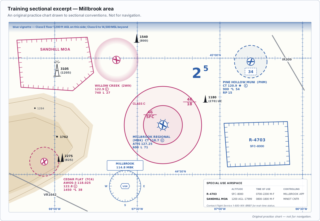
Many restricted areas are joint use: when the military is not using them, the controlling ATC facility releases the airspace and traffic flows straight through. That is why the tabulation panel lists a controlling agency as well as a using agency. If you have a recurring job near one, a phone call to the range control office and a standing arrangement is often far easier than everyone expects.
- Special use airspace comes in seven types: Prohibited, Restricted, Warning, MOA, Alert, Controlled Firing Area and National Security Area
- Prohibited, Restricted and Warning areas are charted with a blue hachured band
- Alert Areas and MOAs are charted with a magenta hachured band
- Prohibited and Restricted areas are regulatory airspace established under 14 CFR Part 73
- §107.45 requires permission from the using or controlling agency for prohibited or restricted areas
- A Controlled Firing Area is never charted because activity stops when an aircraft approaches
- The chart tabulation panel lists MOAs alphabetically and P, R, W and A areas numerically