Track your progress, take practice exams, and study the flashcards in the app.
2.6 Reading a Sectional III — Obstructions, Terrain, MEF, Latitude and Longitude
- Decode an obstruction symbol and its two heights, and derive the ground elevation from them
- Explain what the Maximum Elevation Figure includes and why it is not a legal altitude limit
- Locate a position on a sectional by latitude and longitude to the nearest minute
Everything on a sectional that is not airspace is terrain, obstacles or position. For a drone pilot flying at 400 feet these are not background detail — a 300-foot tower is the single most likely thing you will hit, and the chart is where you find it before you are standing under it.
Obstruction symbols
An obstruction is a man-made object charted because it sticks up far enough to matter. The FAA charts man-made obstacles that extend more than 200 feet AGL, and inside the yellow city tint the threshold rises to more than 299 feet AGL so the chart does not become unreadable in urban areas.
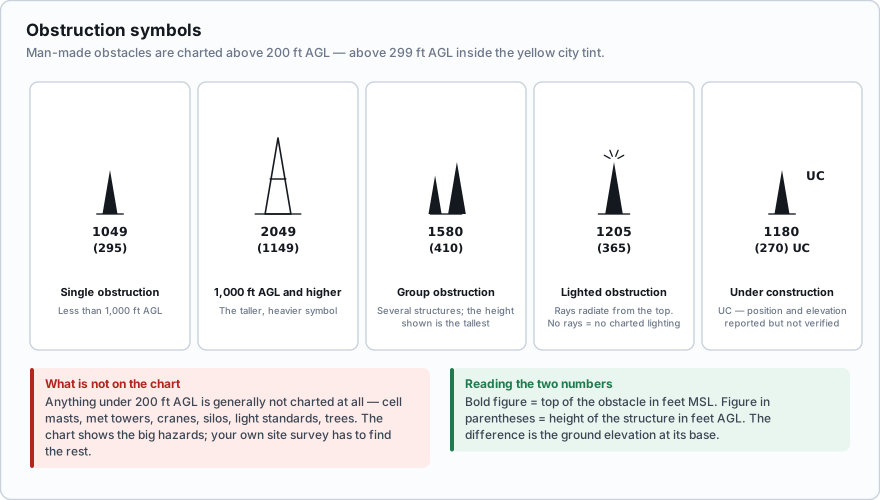
- Single obstruction — a narrow spike symbol.
- Obstruction 1,000 feet AGL or higher — a taller, heavier symbol. These are the broadcast towers you can see from ten miles away.
- Group obstruction — two spikes side by side, meaning several structures clustered together. The height shown is the tallest one.
- Lighted obstruction — small rays radiating from the top of the symbol. No rays means no charted lighting.
- UC printed beside the symbol — under construction, or the position and elevation are reported but unverified. Treat a UC obstacle as real and possibly taller than charted.
Sit with that charting threshold. Anything under 200 feet AGL is generally not on the chart at all — cell towers, meteorological evaluation towers, construction cranes, silos, light standards, the flagpole at the school. All of it lives in the airspace you fly in. The chart shows you the big hazards. Your own site survey has to find the rest.
Reading the two heights
Every charted obstruction carries up to two numbers.
- The bold figure is the elevation of the top of the obstacle above mean sea level (MSL).
- The figure in parentheses below it is the height of the structure itself, in feet AGL.
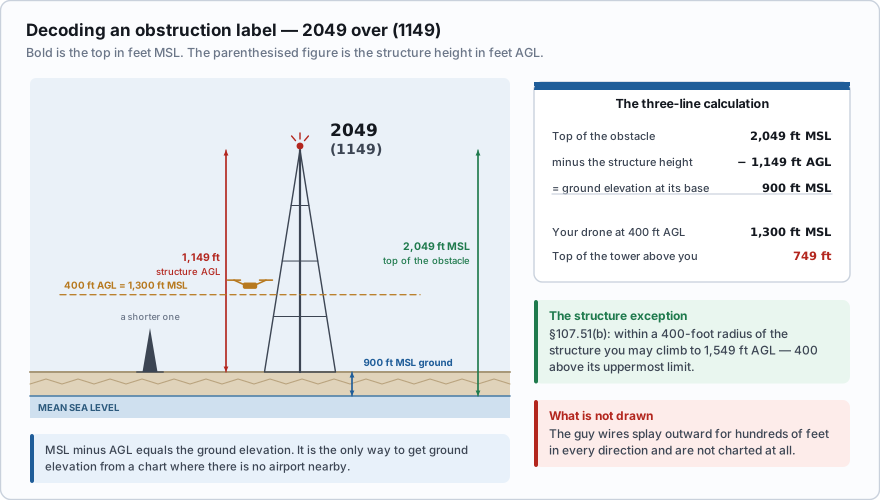
A tower on the chart is labeled: 2049 (1149) The top of that tower is 2,049 feet MSL. The tower itself is 1,149 feet tall. So the ground it stands on is: 2,049 − 1,149 = 900 feet MSL. Now put yourself next to it. You launch from that same terrain and climb to your legal 400 feet AGL, which is 900 + 400 = 1,300 feet MSL. The top of the tower is 2,049 − 1,300 = 749 feet above you. The guy wires supporting it, however, splay outward and downward across the ground for hundreds of feet in every direction, and they are not charted at all. This three-line calculation — top MSL, minus structure AGL, equals ground MSL — is worth practicing until it is automatic. It is the only way to get ground elevation from a chart at a spot with no airport nearby.
An obstruction is charted as 1580 with (295) beneath it. What is the ground elevation at the base of the structure?
- 1,875 feet MSL
- 1,285 feet MSL
- 295 feet MSL
Answer: B. The bold figure is the top in MSL and the parenthesised figure is the structure height in AGL. 1,580 − 295 = 1,285 feet MSL at the base.
A small unmanned aircraft may not be flown higher than 400 feet above ground level, unless it is flown within a 400-foot radius of a structure and does not fly higher than 400 feet above the structure's immediate uppermost limit.
That exception is why obstruction heights matter operationally as well as academically. Inspecting the 1,149-foot tower above, you may legally climb to 1,549 feet AGL — 400 above its top — as long as you stay within 400 feet horizontally of the structure and maintain visual line of sight. Step outside that radius and your ceiling snaps back to 400 AGL.
Terrain and the Maximum Elevation Figure
Terrain appears as contour lines joining points of equal elevation, color tints that get darker as the ground rises, and spot elevations — a dot with a number for the highest point of a local feature. The highest terrain on the entire chart is printed with a heavier dot and label.
Laid over all of it, in every 30-minute-by-30-minute quadrant of latitude and longitude, is a large pair of numbers called the Maximum Elevation Figure (MEF).
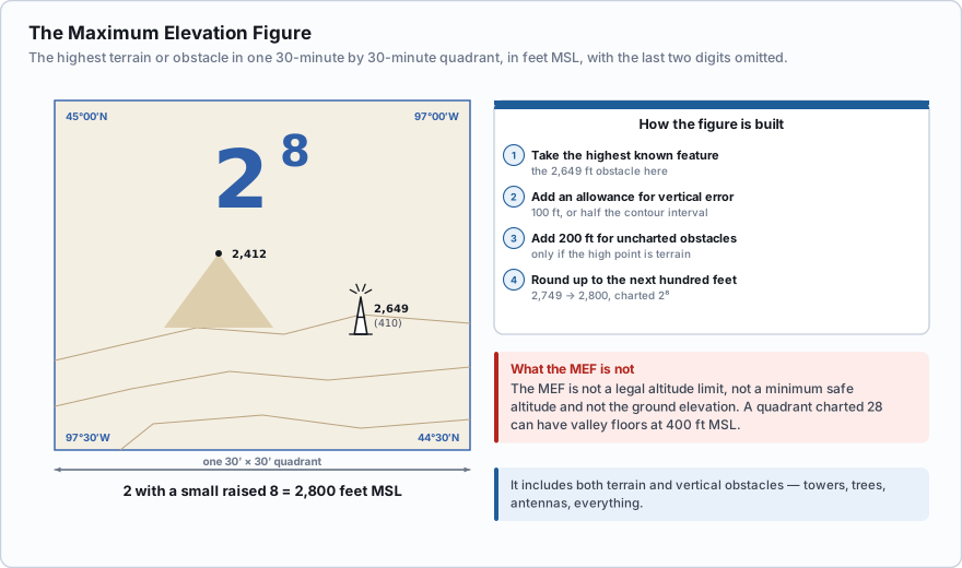
- The MEF gives the highest elevation in that quadrant in feet MSL, and it includes both terrain and vertical obstacles — towers, trees, antennas, everything.
- It is printed with the last two digits omitted. A large 12 with a small raised 5 means 12,500 feet MSL.
- It is derived by taking the highest known feature, adding an allowance for vertical error (100 feet, or half the contour interval where that exceeds 200 feet), adding a further 200 feet for uncharted obstacles if the high point is natural terrain, and then rounding up to the next hundred feet.
From a man-made obstacle. Top of the obstacle is 2,649 feet MSL. Add 100 feet of possible vertical error → 2,749. Round up to the next hundred → 2,800 feet MSL. The quadrant is charted 2⁸. From natural terrain. Highest feature is 13,161 feet MSL. Add 100 feet of error → 13,261. Add the 200-foot allowance for uncharted obstacles → 13,461. Round up → 13,500 feet MSL. The quadrant is charted 13⁵.
The MEF is not a legal altitude limit, not a minimum safe altitude, and not the ground elevation. It is a clearance figure telling you the highest thing in a 30-by-30-minute box. A quadrant with an MEF of 2,800 can have valley floors at 400 feet MSL. Never use an MEF to work out how high you are above the ground, and never assume you may climb to it.
Latitude and longitude
Positions on a sectional are given in degrees and minutes.
- Latitude measures north and south of the equator. The lines run east–west across the chart. Latitude increases going north.
- Longitude measures east and west of the prime meridian at Greenwich. The lines run north–south. In the United States, longitude is always west.
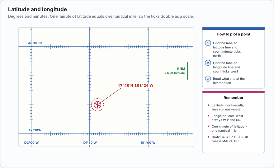
Each degree is divided into 60 minutes, and sectionals carry a tick mark for every minute along the graticule lines. To find a point such as 47°40′N, 101°26′W, you find the 47° latitude line, count 40 ticks north, find the 101° longitude line, count 26 ticks west, and read what is at the intersection. That is exactly how an FAA sample question asks you to identify an airport.
One useful fact: one minute of latitude equals one nautical mile. The tick marks along a line of longitude therefore double as a distance scale you can step off with a pencil or your fingers when no scale bar is handy.
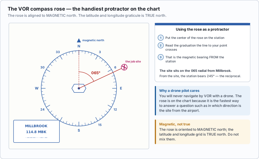
Around each VOR navigation station the chart prints a compass rose aligned to magnetic north. You will not navigate by VOR with a drone, but the rose is the handiest protractor on the chart for answering a question such as *in which direction is the drone from the airport*. Remember the rose is magnetic while the latitude and longitude grid is true.
A sectional quadrant shows a Maximum Elevation Figure of 3 with a small raised 6. What does it tell you?
- The highest terrain and obstacle in that quadrant reaches 3,600 feet MSL
- You may not fly above 3,600 feet MSL in that quadrant
- The ground elevation throughout that quadrant is 3,600 feet MSL
Answer: A. The MEF gives the highest elevation, terrain and obstacles combined, with the last two digits omitted. It is informational, not regulatory, and it says nothing about the ground elevation anywhere else in the quadrant.
- Man-made obstacles are charted above 200 ft AGL (299 ft AGL in the yellow city tint). Below that, they are your problem to find.
- Obstruction labels: bold = top in feet MSL, parentheses = structure height in feet AGL. MSL minus AGL = ground elevation.
- Obstacles 1,000 ft AGL and higher get a taller symbol; rays mean lighted; UC means under construction or unverified.
- MEF = highest terrain and obstacle in a 30-minute quadrant, in MSL, with the last two digits omitted. It is not a legal limit.
- Latitude is north/south of the equator; longitude is east/west of the prime meridian. 1 minute of latitude = 1 NM.
- §107.51(b): within 400 feet horizontally of a structure you may climb to 400 feet above its uppermost limit.
Meteorological evaluation towers — the thin guyed masts erected to measure wind before a wind farm is built — are frequently under 200 feet AGL and therefore uncharted, unlit and nearly invisible against terrain. They have killed agricultural pilots. If you work rural acreage, drive the site first, and treat every guyed structure as having wires reaching much farther out than the mast looks.
- Man-made obstacles are charted above 200 feet AGL, or above 299 feet AGL inside the yellow city tint
- An obstruction shows its top in bold MSL over its structure height in parentheses AGL
- Subtracting the AGL height from the MSL top gives the ground elevation at the base
- The MEF is the highest terrain and obstacle in a 30-minute quadrant, in MSL, with the last two digits omitted
- The MEF is informational only — it is not a legal altitude limit and not a ground elevation
- Latitude is measured north and south of the equator; longitude east and west of the prime meridian
- One minute of latitude equals one nautical mile, which makes the graticule a distance scale