Track your progress, take practice exams, and study the flashcards in the app.
2.4 Reading a Sectional I — Colors, Lines, and Boxes
- Identify every airspace boundary on a sectional from its line style and color alone
- Explain which side of a vignette has the lower Class E floor and why
- Read any charted altitude box, including SFC, the minus convention and the Class D bracket
A sectional aeronautical chart is a 1:500,000 scale map of the airspace, named for a major city near its center — the Charlotte sectional, the Seattle sectional, and so on. It carries terrain, obstructions, airports, radio frequencies and every airspace boundary, all in a color and line-style code that takes about twenty minutes to learn and then never leaves you.
Roughly a third of the questions people miss on this exam come from charts. This lesson is the decoder. Read it with the training sectional open beside you.
The line and color decoder
There are only two colors in the airspace code — blue and magenta — and only a handful of line treatments. Every combination means one specific thing.
| What you see | What it is | Authorization? |
|---|---|---|
| Solid blue line | Class B | Yes |
| Solid magenta line | Class C | Yes |
| Dashed blue line | Class D | Yes |
| Dashed magenta line | Class E surface area | Yes |
| Magenta vignette (soft-edged band) | Class E floor at 700 ft AGL | No |
| Blue vignette (soft-edged band) | Class E floor at 1,200 ft AGL where it abuts Class G | No |
| Blue line with tick marks (a *zipper*) plus a number | Class E with some other charted floor, printed in MSL | No |
| Solid magenta thin ring, 30 NM radius | Mode C veil around Class B | No |
| Blue hachured band (hatch marks on the inside edge) | Prohibited, Restricted or Warning area | See §107.45 |
| Magenta hachured band | Alert Area or MOA | No, but check activity |
| Broken magenta line around a facility | National Security Area | No, unless a NOTAM says so |
| Screened black outline | Terminal Radar Service Area (TRSA) | No |
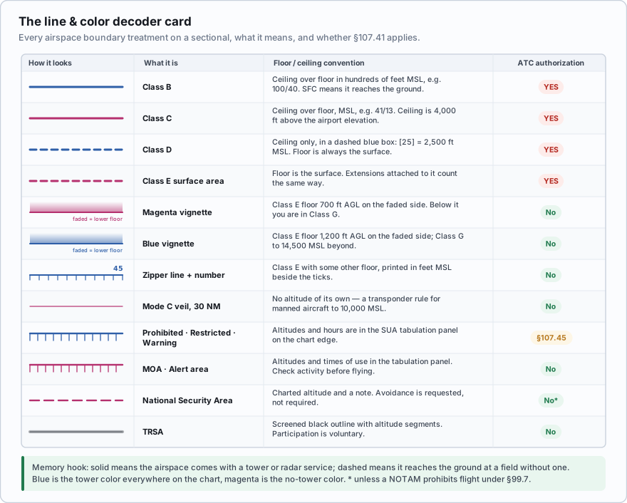
A memory hook that actually holds up: solid means the airspace comes with a radar or tower service; dashed means it reaches the ground at a field without one. Blue is the tower color throughout the chart — control towers, Class B, Class D, towered airport symbols — and magenta is the no-tower color.
A sectional shows a boundary drawn as a dashed blue line. What airspace is it, and does a Part 107 flight inside it need authorization?
- Class E surface area; authorization required
- Class D; authorization required
- Class C; authorization not required
Answer: B. Dashed blue is Class D, which always means an operating control tower. §107.41 lists Class D, so prior ATC authorization is required. Dashed *magenta* would be a Class E surface area.
Vignettes — the thing everyone inverts
A vignette is a soft-edged band of color laid along a boundary. It fades out on one side. Which side it fades toward is the whole message, and this is where students reliably get it backwards.
The soft, faded side of a vignette points toward the airspace with the *lower* Class E floor — the more controlled side. The crisp, dense edge sits on the boundary, with the *higher* floor on the other side of it.
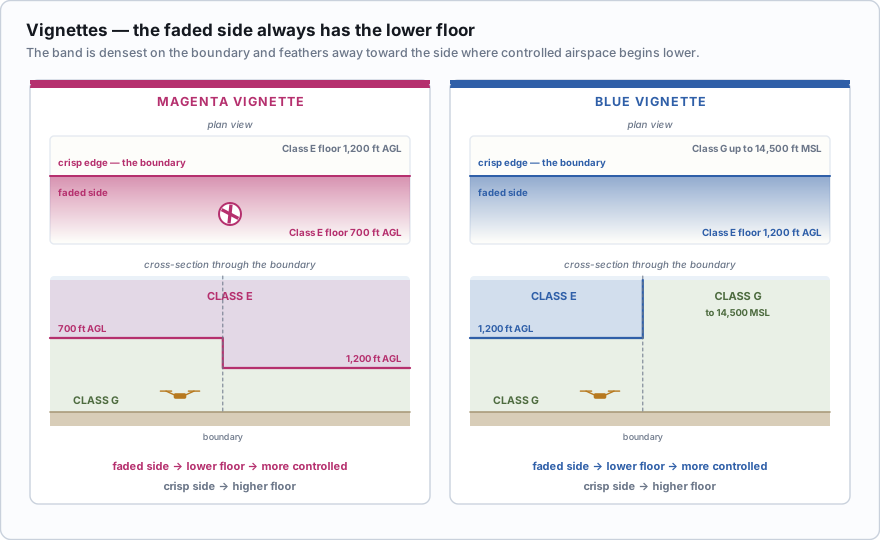
- Magenta vignette. On the faded side, Class E begins at 700 feet AGL. Across the crisp edge, the floor is higher — usually 1,200 feet AGL. In practice the faded side is the side the airport is on, because the whole point is to lower the protection near an instrument approach.
- Blue vignette. On the faded side, Class E begins at 1,200 feet AGL. Across the crisp edge, there is no low Class E at all and Class G continues up to 14,500 feet MSL.
There is a shortcut worth internalising for the magenta case, because it is the one you will meet almost every working day: if a non-towered airport sits inside a soft magenta band, the Class E floor over that airport is 700 feet AGL, and a drone below 400 feet is in Class G.
The third variant is the zipper line — a blue line with short tick marks along one side, printed with a number beside it. It marks a Class E floor at some altitude other than 700 or 1,200 feet, and the number is that floor in MSL. You will see it in mountainous country, where a floor keyed to the ground would be useless because the ground moves. Read the number, subtract the local ground elevation, and you have the height above your launch point.
You are hired to photograph a farm ten miles from a small non-towered airport. On the chart the airport sits inside a soft magenta band, and your farm is outside the crisp edge of that band, in plain white chart with no shading at all. Inside the band, the Class E floor is 700 feet AGL. Outside it, across the crisp edge, the floor reverts to 1,200 feet AGL. Either way, your flight at 350 feet AGL is in Class G, and no authorization is required. The vignette changed where controlled airspace begins. It never came near your altitude.
The wrong answer people pick: *the magenta shading is Class E, therefore I am in Class E.* You are not in it if you are underneath it. Shading tells you where the floor is. It never tells you that the airspace touches the ground. Only a dashed magenta line does that.
Reading altitude boxes
Airspace altitudes are printed in a compact format that looks cryptic until you know four rules.
- The last two zeros are omitted. 40 means 4,000 feet. 100 means 10,000 feet. 7 means 700 feet.
- Everything is MSL unless the chart explicitly says otherwise. Class B and C altitude figures are always mean sea level.
- Ceiling on top, floor on the bottom, separated by a line. 100/40 is a ceiling of 10,000 MSL over a floor of 4,000 MSL.
- SFC means surface. 100/SFC is Class airspace from the ground up to 10,000 MSL — you are standing in it.
![Decoding charted altitudes: 100/40, 70/30, 100/SFC, the minus convention, and the Class D dashed bracket [25].](/figures/fig-altitude-boxes.svg)
Two more conventions complete the set.
The minus sign. A figure preceded by a minus — for example -18 — means *from the surface to, but not including, 1,800 feet MSL*. It is used where one piece of airspace stops immediately beneath another so the two do not overlap. Read the minus as up to but not including, never as *below sea level* and never as a negative number.
The Class D bracket. A Class D ceiling appears as a number inside a small dashed blue box, for example [25]. That is 2,500 feet MSL, the top of the Class D. The dashed box matches the dashed boundary line so you can pair them at a glance.
100/40 in solid blue — Class B shelf, 10,000 MSL down to 4,000 MSL. 41/13 in solid magenta — Class C shelf, 4,100 MSL down to 1,300 MSL. 70/SFC in solid blue — Class B from the surface to 7,000 MSL. Authorization needed before you launch. [25] in a dashed blue box — Class D ceiling at 2,500 MSL. Everything from the surface to 2,500 MSL inside that dashed line is Class D.
A charted Class B segment reads 100/40. Your job site has a ground elevation of 500 feet MSL. How high can you climb before entering Class B?
- 3,500 feet AGL, though §107.51 caps you at 400 feet AGL
- 4,000 feet AGL
- 400 feet, because the floor is 40 feet MSL
Answer: A. The floor is 4,000 feet MSL. Subtract the ground elevation: 4,000 − 500 = 3,500 feet AGL. You would reach the Class B at 3,500 AGL, but §107.51(b) stops you at 400 AGL long before that, so the shelf is not a factor.
- Solid blue = B · solid magenta = C · dashed blue = D · dashed magenta = Class E surface area.
- Magenta vignette = Class E floor 700 ft AGL. Blue vignette = Class E floor 1,200 ft AGL. The faded side has the lower floor.
- A zipper line (blue with tick marks) plus a number marks a Class E floor at some other altitude, in MSL.
- Charted altitudes are MSL with the last two zeros dropped, ceiling over floor, and SFC means surface.
- A minus in front of a figure means up to but not including that altitude.
- A dashed blue box such as [25] is a Class D ceiling in hundreds of feet MSL.
Sectionals are revised on a published cycle and the FAA posts the effective dates for every chart. Any chart you rely on — paper or in an app — should be the current edition, because airspace changes. A Class D that went part-time, a new Class E surface area, a tower that came down: all of it arrives on the next chart. Flying an expired chart is a preflight failure under §107.49(a)(2), which requires you to assess local airspace and flight restrictions.
Spend ten minutes tracing every colored boundary on the training sectional and naming it out loud before moving on. Speed on chart questions comes from recognition, not reasoning.
- Solid blue is Class B, solid magenta is Class C, dashed blue is Class D, dashed magenta is a Class E surface area
- A magenta vignette marks a 700 ft AGL Class E floor; a blue vignette marks a 1,200 ft AGL floor
- The faded side of a vignette is the side with the lower Class E floor; the crisp edge is the boundary
- Charted altitudes are MSL with the last two zeros omitted, ceiling over floor, SFC meaning surface
- A minus sign before a figure means up to but not including that altitude
- A Class D ceiling appears as hundreds of feet MSL inside a dashed blue box, such as [25]
- The Mode C veil is a thin solid magenta 30 NM ring and carries no Part 107 requirement