Track your progress, take practice exams, and study the flashcards in the app.
2.3 Class D, C, and B — The Airspace You Need Permission For
- State the standard dimensions and vertical limits of Class D, C and B airspace
- Read a charted Class B or C altitude box and decide which shelf you are underneath
- Distinguish Class B airspace from the Mode C veil and Class C from its outer area
These three classes wrap around airports with control towers, and all three appear in §107.41. If your job site is inside Class B, C or D, you need prior ATC authorization before the aircraft leaves the ground. That is the practical headline. The rest of this lesson is about recognizing them and reading their altitudes correctly, because the exam loves to ask *what is the floor of that shelf*.
Class D — one tower, one cylinder
Class D exists around an airport that has an operating control tower but does not have enough traffic to justify Class C or B. It is the simplest shape in the system: a cylinder, typically about 4 to 5 nautical miles in radius, sometimes with a rectangular extension sticking out where an instrument approach comes in.
Class D extends from the surface up to 2,500 feet above the airport elevation. The FAA charts that ceiling in MSL, rounded to a convenient hundred-foot value, and prints it inside a dashed blue box. A box reading [25] means the ceiling is 2,500 feet MSL — not 2,500 AGL.
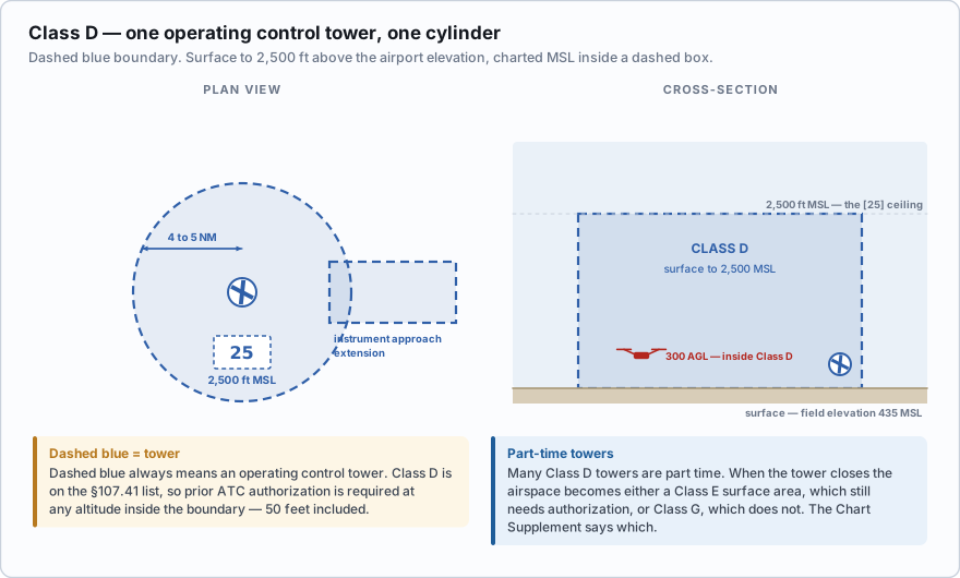
The boundary line is blue and dashed. Learn that pairing now: dashed blue = Class D, and it always means a tower.
Many Class D towers are part-time. When the tower closes, the airspace normally reverts to either a Class E surface area or Class G, depending on what the FAA designated. This matters: if it reverts to Class E surface area, §107.41 still applies; if it reverts to Class G, it does not. The Chart Supplement entry for the airport spells out the hours and what the airspace becomes. When in doubt, request the authorization.
Class C — a core, a shelf, and an outer area
Class C surrounds an airport with a tower and radar approach control, with more traffic than a Class D field. The standard shape has three parts, and only two of them are Class C at all.
- The core: a 5 NM radius circle from the surface up to 4,000 feet above the airport elevation.
- The shelf: a 10 NM radius ring extending from 1,200 feet up to 4,000 feet above the airport elevation. Both bounds are referenced to the airport's elevation, not to the ground beneath you.
- The outer area: a 20 NM radius zone in which radar service is available. It is not Class C airspace, it is not charted on a sectional, and it requires no authorization.
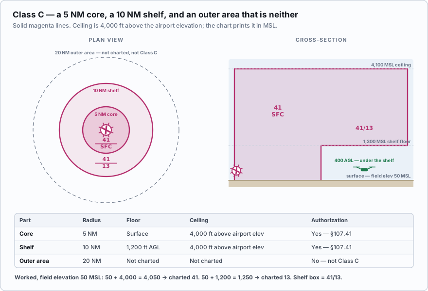
Class C boundaries are drawn with a solid magenta line, and its altitudes are printed in solid magenta figures with the last two zeros dropped. Both the ceiling and the floor are MSL.
A coastal Class C airport has a field elevation of about 50 feet MSL. Work out what the chart should say. Ceiling = 4,000 feet above airport elevation = 50 + 4,000 = 4,050 → charted as 4,100 MSL, printed 41. Shelf floor = 1,200 feet above airport elevation = 50 + 1,200 = 1,250 → charted as 1,300 MSL, printed 13. So the shelf box reads 41/13, and the core box reads 41/SFC. This is exactly the arithmetic behind an official FAA sample question about the Savannah Class C, where the correct answer for the shelf floor is 1,300 feet MSL — not 1,300 AGL, and not 1,700 MSL. The chart speaks MSL.
The outer shelf of a Class C is charted 41/13. A remote pilot is working at a site under that shelf at 300 feet AGL, where the ground is 60 feet MSL. What is the situation?
- The drone is inside Class C and needs prior ATC authorization
- The drone is beneath the Class C shelf, in Class E or G, and §107.41 does not apply to that airspace
- The drone is inside the Class C outer area and must contact approach control
Answer: B. The shelf floor is 1,300 feet MSL. The drone is at 60 + 300 = 360 feet MSL, roughly 940 feet below the shelf. It is underneath the Class C, not inside it. Always confirm what airspace you *are* in, and note that a Class C surface area nearby could still reach you.
Class B — the upside-down wedding cake
Class B surrounds the nation's busiest airports. It normally runs from the surface up to 10,000 feet MSL and is built in shelves that step outward and upward, which is where the wedding-cake description comes from. Each shelf has its own ceiling and floor, and each is printed on the chart in solid blue figures with the last two zeros omitted.
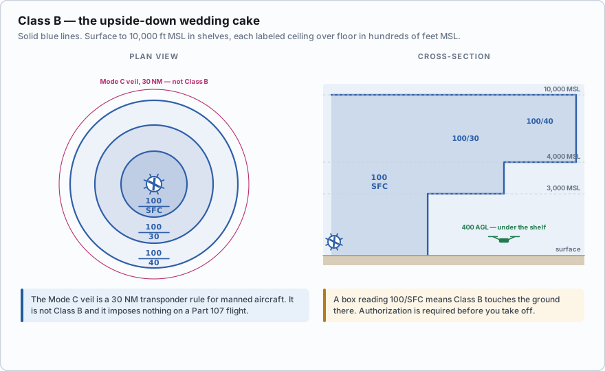
Class B boundaries are solid blue lines. A box reading 100/40 means the shelf above you runs from 4,000 feet MSL up to 10,000 feet MSL. A box reading 100/SFC means that piece of Class B comes all the way down to the ground — you are standing in it.
You are filming a downtown high-rise. Ground elevation is 600 feet MSL. The chart segment covering your block reads 80/30. The Class B floor above you is 3,000 feet MSL, which is 3,000 − 600 = 2,400 feet above your ground. Flying at 400 AGL, you are comfortably underneath it and outside Class B. Walk two blocks north and the next segment reads 80/SFC. Now the Class B reaches the pavement. You are inside Class B and §107.41 applies. The airspace boundary is a line on a map, and it can run down the middle of a street.
The Mode C veil is not Class B
Around every Class B airport the chart shows a large, thin solid magenta circle with a 30 NM radius. That is the Mode C veil — the area within which manned aircraft must carry an altitude-reporting transponder from the surface to 10,000 feet MSL.
It is not Class B, it is not Class C, and it imposes nothing on a Part 107 operation. In fact §107.52 forbids you from operating with a transponder on. Treat the veil as a useful landmark: if you can see it on the chart, a very busy airport is within 30 nautical miles, and you should be paying attention. But crossing it costs you nothing.
- Class D: surface to 2,500 ft above airport elevation, charted MSL in a dashed blue box. Boundary is a dashed blue line.
- Class C: 5 NM core surface to 4,000 ft above airport elevation; 10 NM shelf from 1,200 ft above airport elevation to the same ceiling; 20 NM outer area is not charted and not Class C. Boundary is a solid magenta line.
- Class B: normally surface to 10,000 ft MSL in shelves. Boundary is a solid blue line.
- All charted airspace altitudes are MSL with the last two zeros omitted. 100/40 = 10,000 over 4,000 MSL.
- The Mode C veil is a solid magenta 30 NM ring around Class B. It is a transponder rule for manned aircraft and means nothing for Part 107.
- Class B, C and D all require prior ATC authorization under §107.41.
Two favorites live in this lesson. First, answering a Class C ceiling question with 4,000 feet AGL — the dimension is defined as 4,000 above the airport elevation, but the number on the chart is MSL. Second, treating the 20 NM Class C outer area or the 30 NM Mode C veil as airspace requiring authorization. Neither does.
A sectional shows a Class B segment labeled 70/SFC where you plan to work. What does this mean for your Part 107 flight?
- Class B begins at 7,000 feet MSL, so you are clear of it
- Class B extends from the surface to 7,000 feet MSL there, so prior ATC authorization is required
- You may fly up to 700 feet AGL without authorization
Answer: B. The upper figure is the ceiling and the lower is the floor. SFC means surface. Class B reaches the ground at that spot, so §107.41 applies before you take off.
Class B shapes are individually designed and published in 14 CFR Part 71, which is why no two look alike. Some, like the Los Angeles Class B, contain a charted VFR corridor that manned aircraft can transit without a clearance. Corridors are a manned-aircraft convenience. They do not create an exception for drones — if the corridor is inside the Class B lateral boundary at your altitude, you still need authorization.
- Class B, Class C and Class D all require prior ATC authorization under §107.41
- Class D runs from the surface to 2,500 feet above the airport elevation, charted MSL in a dashed blue box
- Class C has a 5 NM core (surface to 4,000 above field), a 10 NM shelf (1,200 feet above airport elevation to the same ceiling) and an uncharted 20 NM outer area
- Class B normally runs from the surface to 10,000 feet MSL and is built in shelves
- Charted airspace altitudes are always MSL with the last two zeros omitted; SFC means surface
- The 30 NM Mode C veil is a solid magenta ring and imposes no requirement on Part 107 operations