Track your progress, take practice exams, and study the flashcards in the app.
2.2 Class G and Class E — Where Most Drone Work Happens
- Describe the vertical limits of Class G airspace and the three common cases
- Identify the five kinds of Class E airspace and the floor each one uses
- Determine correctly whether a given Class E area requires prior ATC authorization
If you learn one concept perfectly in this entire module, make it this one. The single most-missed idea on the Part 107 exam is the difference between Class E at 700 feet AGL and a Class E surface area. One needs nothing from anybody. The other needs prior ATC authorization. They are both magenta on the chart, and they look nothing alike once you know what to look for.
Class G — uncontrolled airspace
Class G is airspace where ATC provides no separation service to anyone. It begins at the surface and ends where the controlled airspace above it begins. That is the entire definition. Class G has no lower limit problem and no chart symbol of its own — you identify Class G by finding out what is above it and subtracting.
Three cases cover almost everything you will meet:
- Class G from the surface up to 700 feet AGL. This is what sits under a magenta vignette — the soft-edged magenta band around airports that have an instrument approach. Above 700 AGL it becomes Class E.
- Class G from the surface up to 1,200 feet AGL. The most common case across the eastern and central United States. Above 1,200 AGL it becomes Class E.
- Class G from the surface up to 14,500 feet MSL. Found in remote parts of the mountain West and Alaska where no controlled airspace was ever needed down low.
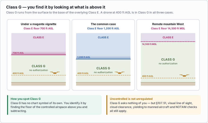
Notice what all three cases share. A drone flying at or below 400 feet AGL is in Class G in every one of them. No authorization. No LAANC. No phone call. Every other Part 107 rule still applies — visual line of sight, 3 statute miles of visibility, cloud clearance, yielding to manned aircraft, checking NOTAMs — but the airspace itself asks nothing of you.
A remote pilot is operating at 350 feet AGL beneath a magenta vignette (Class E floor at 700 feet AGL). What airspace is the drone in?
- Class E, and ATC authorization is required
- Class G, and no ATC authorization is required
- Class E, but no authorization is required because the drone is below 400 feet
Answer: B. Class E in that area begins at 700 feet AGL. Everything below 700 AGL is Class G. The drone is in uncontrolled airspace and needs no authorization.
Class E — the catch-all controlled airspace
Class E is every piece of controlled airspace that is not A, B, C or D. It exists to protect aircraft flying on instruments, most often while they are descending toward an airport or climbing away from one. Because those aircraft need protection at different heights in different places, Class E comes with several different floors.
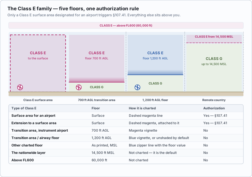
| Type of Class E | Floor | How it is charted | Authorization needed? |
|---|---|---|---|
| Surface area designated for an airport | The surface | Dashed magenta line | Yes — §107.41 |
| Extension to a surface area (B, C, D or E) | The surface | Dashed magenta line attached to the main area | Yes if it is part of a Class E surface area |
| Transition area over an airport with an instrument approach | 700 ft AGL | Magenta vignette (soft-edged band) | No |
| Transition area / airway floor | 1,200 ft AGL | Blue vignette, or unshaded where it is the default | No |
| Other charted floor | Whatever is printed, in MSL | Blue line with tick marks (a *zipper*) and the floor value | No |
| The nationwide layer | 14,500 ft MSL | Not charted — it is the default | No |
| Above FL600 | 60,000 ft | Not charted | No |
The one Class E that needs authorization
A Class E surface area designated for an airport is controlled airspace that reaches all the way down to the ground at an airport that has no control tower. The FAA establishes one when an airport has both weather reporting and communications capability down to the runway, so that instrument arrivals can be handled safely without a tower.
On a sectional it is drawn as a dashed magenta line — a broken line, not shading. Inside that line, the ground is inside controlled airspace, so a drone sitting on the pavement is already in Class E. §107.41 applies, and you need prior ATC authorization before you take off.
Everything else in the Class E family — the 700-foot floor, the 1,200-foot floor, the airways, the 14,500-foot layer — sits above you and requires nothing.
One variation is worth recognizing because it looks unfamiliar the first time. A Class E surface area often has an extension — a finger of dashed magenta sticking out from the main circle, lined up with an instrument approach. The extension is part of the surface area, reaches the ground the same way, and carries the same §107.41 obligation. If your job site sits inside a dashed magenta shape, its geometry does not matter.
Two more members of the family exist purely as background. Federal airways — the highways manned aircraft navigate along — are Class E from 1,200 feet AGL up to 18,000 feet MSL, and they are drawn as pale blue bands with names such as V-16. And across the entire lower 48, Class E fills in from 14,500 feet MSL up to but not including 18,000 feet MSL, where Class A takes over. Neither is charted with a boundary you need to worry about, and neither is reachable by a small drone.
- Class G runs from the surface to the base of the overlying Class E: usually 700 ft AGL, 1,200 ft AGL, or 14,500 ft MSL.
- A drone at or below 400 ft AGL under a 700 or 1,200 foot Class E floor is in Class G.
- Class E at 700 or 1,200 feet AGL requires no ATC authorization.
- Only a Class E *surface area* designated for an airport triggers §107.41 — drawn as a dashed magenta line.
- Dashed magenta = surface area = call ATC. Soft magenta shading = 700 ft floor = go fly.
Airport A is a non-towered grass strip. On the chart it sits inside a soft magenta band — a vignette — with no dashed line anywhere. The Class E floor there is 700 feet AGL. You are shooting construction progress photos at 250 feet AGL. You are in Class G. No authorization is required. You still check NOTAMs, still monitor the CTAF, and still keep clear of the traffic pattern under §107.43. Airport B is also non-towered, but it has an instrument approach with weather reporting, and the chart shows a dashed magenta ring around it. The Class E floor is the surface. Your job site is inside that ring. §107.41 applies. You need prior ATC authorization before the aircraft leaves the ground — normally through LAANC, which you will learn in Lesson 2.10.
Which chart depiction tells a remote pilot that prior ATC authorization is required?
- A soft-edged magenta band around an airport
- A broken (dashed) magenta line around an airport
- A soft-edged blue band along a boundary
Answer: B. A dashed magenta line marks a Class E surface area, which reaches the ground and is listed in §107.41. A magenta vignette marks a 700 ft AGL floor and a blue vignette marks a 1,200 ft AGL floor — neither requires authorization.
The classic wrong answer: *the drone is in Class E because there is magenta shading on the chart, so authorization is required.* Shading is not a surface area. Ask yourself where the floor is. If the floor is 700 or 1,200 feet AGL and you are at 400, you are underneath it, in Class G. Only a dashed magenta line brings the controlled airspace down to your launch point.
Why the floors are where they are
This is worth thirty seconds because it makes the whole system make sense. An airplane flying an instrument approach descends toward the runway inside a protected corridor. Far from the airport it is high, so 1,200 feet AGL of protection is plenty. Closer in it is lower, so the FAA lowers the floor to 700 feet AGL. At an airport where the approach continues right down to the pavement and there is weather reporting and radio coverage, the protection goes all the way to the surface. The Class E floor is a picture of how low the instrument traffic gets.
You will sometimes see a Class E surface area that is only active part of the time — for example, when the airport weather observer is on duty. The Chart Supplement entry for that airport spells out the hours. In practice, LAANC and the UAS Facility Map already account for this, so the authorization you receive reflects the airspace as it actually is.
Two chart depictions, two completely different obligations. Learn the dashed magenta line by sight and this stops being a source of missed questions.
- Class G is uncontrolled airspace running from the surface to the base of the overlying Class E
- The three common Class G ceilings are 700 ft AGL, 1,200 ft AGL and 14,500 ft MSL
- A drone at or below 400 ft AGL beneath a 700 or 1,200 foot Class E floor is in Class G
- Class E at 700 or 1,200 feet AGL requires no ATC authorization
- Only a Class E surface area designated for an airport triggers §107.41, and it is drawn with a dashed magenta line
- A magenta vignette means a 700 ft AGL floor; a blue vignette means a 1,200 ft AGL floor