Track your progress, take practice exams, and study the flashcards in the app.
2.1 How US Airspace Is Built
- Name the six classes of US airspace and describe the shape and purpose of each
- Convert confidently between feet MSL and feet AGL
- State which airspace requires prior ATC authorization for a Part 107 flight and which does not
- Describe what air traffic control does and does not do for a remote pilot
Airspace is the part of this exam that makes people quit. It does not have to be. The whole system rests on two ideas, and once those two ideas are solid, everything else is detail you can look up on a chart.
Idea one: the sky is divided into layers and boxes, and each one has a name. Idea two: heights are measured two different ways, and the FAA switches between them constantly. Get those two right and the rest of this module is bookkeeping.
MSL and AGL — the measurement that trips everyone
MSL means *mean sea level*. It is an altitude measured from the ocean, no matter what the ground under you is doing. AGL means *above ground level* — measured from the dirt directly beneath the aircraft. A drone hovering 400 feet over a mountain and a drone hovering 400 feet over a beach are both at 400 AGL, but one of them is thousands of feet higher MSL.
Here is the rule that matters: §107.51(b) limits you in AGL — 400 feet above the ground. Sectional charts describe airspace in MSL. Every airspace question that involves arithmetic is really asking you to move between those two.
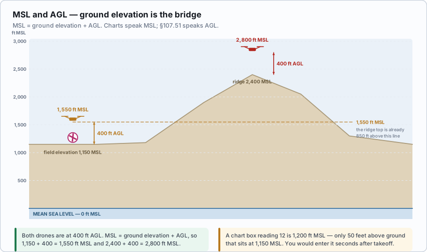
You are flying a roof inspection in a subdivision. The nearest airport on the sectional shows a field elevation of 1,150 feet, and the terrain at your job site is about the same. You launch and climb to your legal ceiling of 400 feet AGL. Your altitude in MSL is 1,150 + 400 = 1,550 feet MSL. Now a chart box over your head reads 28/12. That is 2,800 MSL over 1,200 MSL (you will learn to read these in Lesson 2.4). The floor of that airspace sits at 1,200 MSL, which is 1,200 − 1,150 = 50 feet above your ground. You would enter it almost immediately after takeoff.
The six classes
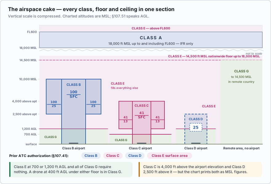
The US uses Classes A, B, C, D, E and G. There is no Class F in the United States — the international system has one, and the FAA skipped it. Airspace that is A, B, C, D or E is controlled. Class G is uncontrolled.
*Controlled* does not mean you need permission. It means air traffic control provides a separation service to *somebody* in that airspace — usually airplanes flying on instruments in cloud. Whether you need permission is a separate question with a much shorter answer, and we will get to it below.
| Class | Where you find it | Typical vertical limits | Part 107 authorization? |
|---|---|---|---|
| A | Everywhere, high up | 18,000 ft MSL up to and including FL600 | Not reachable by a small drone |
| B | The busiest airports (Atlanta, LAX, O'Hare) | Surface to 10,000 ft MSL, in shelves | Yes — prior ATC authorization |
| C | Busy airports with a tower and radar approach control | Surface to 4,000 ft above airport elevation | Yes — prior ATC authorization |
| D | Airports with an operating control tower and little else | Surface to 2,500 ft above airport elevation | Yes — prior ATC authorization |
| E | The catch-all controlled airspace | Floors at the surface, 700 ft AGL, 1,200 ft AGL or 14,500 ft MSL | Only if it is a surface area designated for an airport |
| G | Underneath all of the above | Surface up to the base of the overlying Class E | No authorization needed |
Class A runs from 18,000 feet MSL to and including flight level 600 (roughly 60,000 feet). Everything in it flies on an instrument clearance. A small drone will never be there, and the exam mostly wants you to know it exists and where it starts.
Class B, C and D are all airport airspace. They differ in how busy the airport is and therefore how much airspace gets protected around it. Class B is the largest and most complex, Class D is a single simple cylinder around one tower.
Class E is the connective tissue. Wherever controllers need controlled airspace and no B, C or D fits, they use E. It has several different floors depending on what is going on underneath, which is why it gets a whole lesson of its own.
Class G is what is left over. It starts at the surface and stops where the Class E above it begins. For most commercial drone work in most of the country, Class G is your office.
A drone is hovering at 400 feet AGL over ground that is 900 feet MSL. What is its altitude in MSL?
- 400 feet MSL
- 1,300 feet MSL
- 500 feet MSL
Answer: B. Add the ground elevation to the AGL height: 900 + 400 = 1,300 feet MSL. AGL is measured from the surface below the aircraft; MSL is measured from sea level.
Where you actually need permission
No person may operate a small unmanned aircraft in Class B, Class C, or Class D airspace, or within the lateral boundaries of the surface area of Class E airspace designated for an airport, unless that person has prior authorization from Air Traffic Control.
Read that list again, because it is short and it is the whole answer: B, C, D, and Class E surface areas. That is it. Class E at 700 feet AGL does not require authorization. Class E at 1,200 feet AGL does not require authorization. Class G never requires authorization. Restricted areas need permission too, but from the using agency, not from ATC — a different rule (§107.45) we cover in Lesson 2.7.
- Controlled airspace: A, B, C, D, E. Uncontrolled: G. There is no Class F in the US.
- Class A starts at 18,000 ft MSL and includes FL600.
- Class B typically surface to 10,000 ft MSL; Class C surface to 4,000 ft above airport elevation; Class D surface to 2,500 ft above airport elevation.
- §107.41 requires prior ATC authorization only in Class B, C, D, and Class E surface areas designated for an airport.
- MSL = ground elevation + AGL. Charts speak MSL; §107.51 speaks AGL.
Who ATC is, and what they do for you
Air traffic control is not one office. It is a layered system, and knowing the layers helps you understand who you are actually asking when you request an authorization.
- Airport traffic control towers (ATCT) run the runways and the airspace in the immediate few miles — the Class B, C or D surface area.
- Terminal radar approach control (TRACON) handles arrivals and departures in the busier airspace around a metro area, including Class B and C shelves.
- Air route traffic control centers (ARTCC), called Centers, handle the high-altitude en route structure between cities.
- Flight Service is not a controlling agency at all. It is the briefing and information service — weather, NOTAMs, military route activity. You reach it at 1-800-WX-BRIEF or 1800wxbrief.com.
Here is the part remote pilots consistently misunderstand. An airspace authorization is not a clearance, and ATC is not separating you from anything. Controllers cannot see your drone. Part 107 aircraft are prohibited from operating with a transponder on (§107.52) and prohibited from ADS-B Out in transmit mode (§107.53), so you do not appear on their scopes. The authorization says the facility has reviewed where and how high you intend to fly and accepts it. Everything else — seeing and avoiding traffic, staying out of the way, yielding right of way under §107.37 — stays entirely on you.
Which statement about a Part 107 airspace authorization is correct?
- It is a clearance, and ATC will provide separation from manned traffic
- It permits entry into the airspace; the remote PIC remains responsible for seeing and avoiding all other aircraft
- It requires the remote pilot to activate a transponder so ATC can track the drone
Answer: B. Authorization is permission to be there, not a separation service. §107.37 still requires you to yield the right of way to all aircraft, and §107.52 prohibits operating with a transponder on.
Students see the phrase controlled airspace and assume it means *you need permission*. It does not. Controlled airspace is airspace where ATC provides a service to instrument traffic. Most of the United States above 700 or 1,200 feet AGL is controlled Class E, and a drone at 400 feet AGL underneath it is in Class G and needs nothing from anyone.
The reason the classes are lettered rather than named is that the US adopted the ICAO alphabet system in 1993. Before that, the same airspace had names like *terminal control area* (now Class B), *airport radar service area* (now Class C) and *airport traffic area* (now Class D). You will still hear old-timers use them on the radio, and some airport signage never got updated.
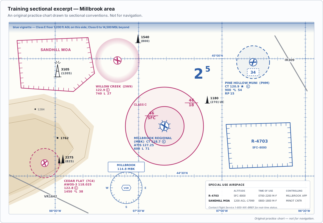
Print or bookmark that excerpt now. The next five lessons all point back to it, and chart reading is a skill that only comes from putting your eyes on a chart repeatedly.
- US airspace uses Classes A, B, C, D, E and G — there is no Class F in the United States
- A, B, C, D and E are controlled; G is uncontrolled. Controlled does not mean you need permission
- MSL is measured from sea level, AGL from the ground below you; MSL = ground elevation + AGL
- Charts describe airspace in MSL; §107.51 limits you to 400 feet AGL
- §107.41 requires prior ATC authorization only in Class B, C, D and Class E surface areas designated for an airport
- An authorization is permission to be in the airspace, not a clearance and not a separation service
- Part 107 drones may not operate with a transponder on or with ADS-B Out transmitting, so ATC cannot see you