Track your progress, take practice exams, and study the flashcards in the app.
2.10 Getting Authorization — LAANC, UAS Facility Maps, DroneZone
- Read a UAS Facility Map grid and state what its value does and does not permit
- Describe the LAANC process, its timing limits and the further coordination path
- State the current rules for operating near an airport, including which obsolete rule no longer applies
You know which airspace needs permission. This lesson is how you get it. The good news is that what used to take weeks now usually takes about thirty seconds on a phone.
Step one — decide whether you need anything
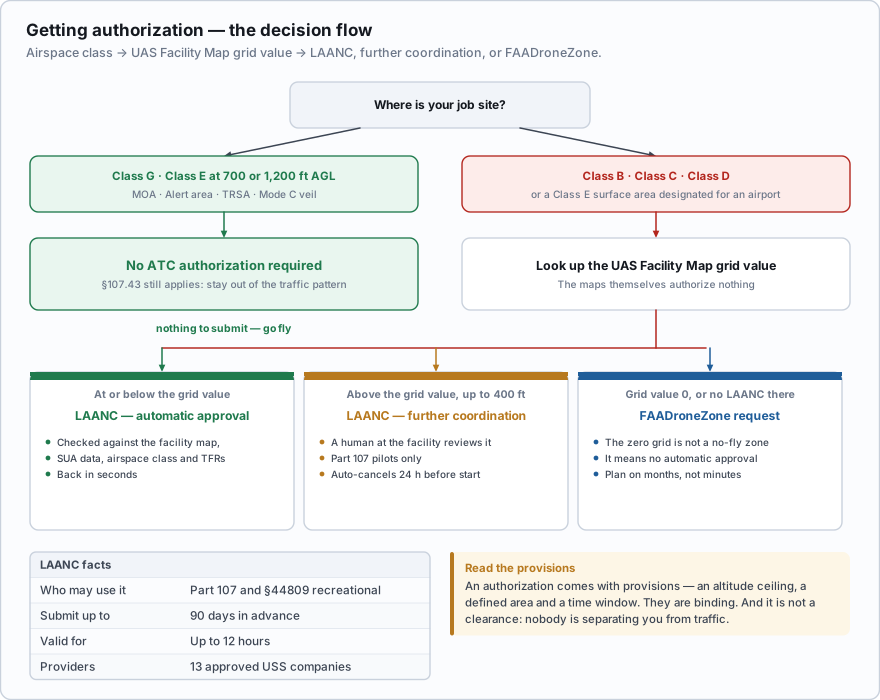
Authorization is required for Class B, Class C, Class D and Class E surface areas designated for an airport. That is the §107.41 list and it has not changed. Class E at 700 or 1,200 feet AGL, Class G, MOAs, alert areas, TRSAs and Mode C veils are not on it.
If your site is in Class G, you are done with this lesson operationally — though everything in the *Operating near airports* section below still applies.
Step two — the UAS Facility Map
A UAS Facility Map (UASFM) is a grid the FAA publishes over every controlled-airspace airport. Each grid square carries an altitude in feet AGL — the maximum height at which the controlling facility has pre-approved drone flights in that square without any additional safety analysis.
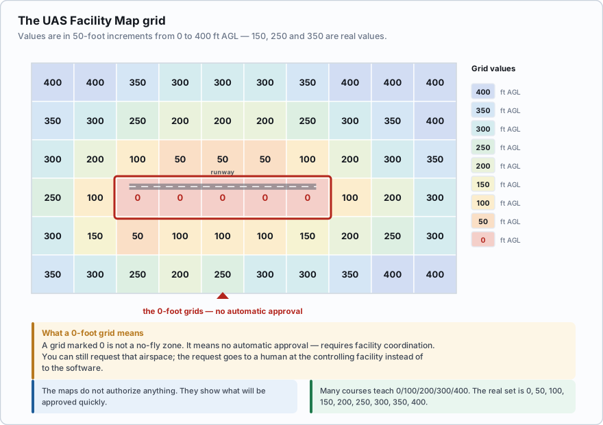
Altitudes will be listed in 50-foot increments, starting at 0 feet (0, 50, etc.) and ending at 400 feet. Zero (0) altitude means no UA flights authorized without facility coordination.
Two things about that come up on the exam and are widely taught wrong.
- The values come in 50-foot increments: 0, 50, 100, 150, 200, 250, 300, 350, 400. Many courses teach a 0/100/200/300/400 set. 150, 250 and 350 are real values and you will see them on real maps.
- A 0-foot grid is not a no-fly zone. It means no automatic approval is available there. You can still request that airspace — it goes to the facility for coordination rather than being approved by software.
The FAA is emphatic on one further point: the maps themselves do not authorize anything. They are a planning tool that tells you in advance what will be approved quickly. You still have to submit the request.
A UAS Facility Map grid over the site you want to work shows a value of 0. What does that mean?
- Drone flight is prohibited in that grid under all circumstances
- No automatic LAANC approval is available there; the request needs facility coordination
- You may fly up to 400 feet because 0 means no restriction
Answer: B. A zero value means no UA flights are authorized without facility coordination. It is not a permanent prohibition — it routes the request to a human at the controlling facility instead of to automatic approval.
Step three — LAANC
LAANC — Low Altitude Authorization and Notification Capability — is a partnership between the FAA and industry that processes airspace authorizations in near real time. You submit through an app or website operated by an FAA-approved UAS Service Supplier (USS). There are currently 13 companies providing public LAANC services, and you may use whichever you like.
Your request is checked automatically against the UAS Facility Map, special use airspace data, airport and airspace class data and active TFRs. If your requested altitude is at or below the grid value and nothing else conflicts, the authorization comes back in seconds.
| Detail | Value |
|---|---|
| Who may use it | Part 107 remote pilots and recreational flyers under the §44809 exception |
| How far ahead you may submit | Up to 90 days in advance |
| How long an authorization is valid | Up to 12 hours |
| Automatic approval | At or below the UASFM grid value for that square |
| Above the grid value, up to 400 ft | Further coordination — a human at the facility reviews it |
| Who may request further coordination | Part 107 pilots only — not recreational flyers |
| Further coordination timing | Requests auto-cancel within 24 hours of the operation start time if not approved; not every USS offers the service |
Further coordination is worth understanding because it is where planning pays. If you need 380 feet in a grid marked 100, the software will not approve it. A Part 107 pilot can submit a further coordination request, which goes to the facility to approve or deny as workload permits. Submit it days ahead, not the morning of the shoot, because an unapproved request cancels itself 24 hours before your start time.
Step four — FAADroneZone
Not every controlled airport participates in LAANC, and not every USS offers further coordination. When LAANC cannot handle your request, you file an airspace authorization request in FAADroneZone. It is slower — plan on months rather than minutes — and it is the route for unusual operations.
Keep two systems straight. Airspace authorizations live in FAADroneZone (or LAANC). Part 107 waivers — deviations from rules such as §107.31 visual line of sight or §107.29 lighting — are now filed through the FAA's Aviation Safety (AVS) Hub. Authorization gets you into airspace. A waiver lets you break a rule. They are different requests to different systems.
What an authorization does and does not do
An authorization comes with provisions — an altitude ceiling, a defined area, a date and time window, sometimes a phone number to call before launching. Those provisions are binding. Exceeding the authorized altitude or drifting outside the authorized polygon puts you in violation as surely as not having an authorization at all.
And it bears repeating from Lesson 2.1: an authorization is not a clearance. Nobody is separating you from traffic. You still yield the right of way to all aircraft under §107.37, still maintain visual line of sight, still comply with every other section of Part 107.
How long is a LAANC authorization valid, and how far in advance may it be requested?
- Valid up to 12 hours; may be submitted up to 90 days in advance
- Valid up to 24 hours; may be submitted up to 30 days in advance
- Valid up to 7 days; may be submitted up to 60 days in advance
Answer: A. LAANC authorizations are valid for up to 12 hours and may be submitted up to 90 days ahead of the flight. Longer or recurring operations need multiple requests or a FAADroneZone submission.
Operating near airports
No person may operate a small unmanned aircraft in a manner that interferes with operations and traffic patterns at any airport, heliport, or seaplane base.
Note the reach of that rule: any airport, heliport or seaplane base — towered or not, Class G or not, public or private. Class G near a busy grass strip still obliges you to stay out of the pattern.
The rule requiring you to notify any airport within 5 miles is obsolete for Part 107. It came from the old Section 336 recreational framework and was retired years ago. Part 107 has never had a notification requirement — it has an authorization requirement in controlled airspace (§107.41) and a non-interference requirement everywhere (§107.43). If a question offers *notify the airport operator and the control tower* as the answer for a Part 107 flight, it is wrong.
What you should actually do near an airport, none of which is a notification:
- Get the authorization if the airspace requires one, and honour its provisions.
- Look up the traffic pattern. Standard patterns are left-hand; the chart marks right-hand patterns as RP followed by the runway number. Pattern altitude for light aircraft is typically about 1,000 feet AGL, but aircraft on final approach descend right through your altitude band.
- Monitor the CTAF on a handheld receiver so you hear arrivals announcing themselves. You are not required to transmit, and at most sites you should not.
- Position yourself off the extended runway centerline, which is where arriving and departing traffic is lowest.
- Brief your visual observer on which direction traffic will come from and what to call out.
- Land immediately if a manned aircraft appears. §107.37 requires you to yield the right of way, and the fastest way to yield is to get on the ground.
- Authorization is required only for Class B, C, D and Class E surface areas (§107.41).
- UASFM values are in 50-foot increments: 0, 50, 100, 150, 200, 250, 300, 350, 400 feet AGL.
- A 0-foot grid means no automatic approval, not a no-fly zone.
- UAS Facility Maps do not authorize anything — they show what will be approved quickly.
- LAANC: 13 USS providers, submit up to 90 days ahead, valid up to 12 hours, further coordination is Part 107 only and auto-cancels 24 hours before start.
- FAADroneZone handles airspace authorizations LAANC cannot; Part 107 waivers are filed in the AVS Hub.
- §107.43: do not interfere with operations or traffic patterns at any airport, heliport or seaplane base.
- The 5-mile airport notification rule does not apply to Part 107.
If you fly the same controlled-airspace site regularly — a construction project, a quarry, a stadium roof — talk to the tower. Facilities can and do issue longer-term arrangements for recurring operators, and a five-minute introduction to the tower supervisor turns you from an anonymous polygon on their screen into a known operator. It changes how quickly further coordination requests come back.
- Prior ATC authorization is required only in Class B, C, D and Class E surface areas designated for an airport
- UAS Facility Map values run in 50-foot increments from 0 to 400 feet AGL
- A 0-foot grid means no automatic LAANC approval, not a prohibition on flight
- UAS Facility Maps are informational and do not themselves authorize any operation
- LAANC is offered by 13 approved UAS Service Suppliers, may be requested up to 90 days ahead and is valid up to 12 hours
- Further coordination lets a Part 107 pilot request above the grid value and is not available to recreational flyers
- The 5-mile airport notification rule is obsolete; §107.43 requires only that you not interfere with airport operations and traffic patterns